Carolina, Suriname

Last updated
Carolina
Road to Jodensavanna (2719399509).jpg
Village on the road to Jodensavanne
Para Resorts Suriname Neutral.png
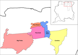
Map showing the resorts of Para District.
  Carolina
CountryFlag of Suriname.svg  Suriname
District Para District
Area
  Total1,441 km2 (556 sq mi)
Elevation
20 m (70 ft)
Population
 (2012) [1]
  Total343
  Density0.24/km2 (0.62/sq mi)
Time zone UTC-3 (AST)

Carolina is a resort in Suriname, located in the Para District. Its population at the 2012 census was 343. Most of the inhabitants are indigenous. [1]

Contents

Settlements

The resort is home to the settlement of Jodensavanne, a Jewish autonomous area which was settled from 1652 onwards, and abandoned after a fire in 1832. [2]

The village of Redi Doti (also Redidoti) is located near the site of Jodensavanne. The village has been founded in 1930, and is home to an indigenous population of about 100 people of mixed Carib and Arowak background. [3]

Blaka Watra is a creek with very dark, near black water. Former Prime minister Johan Adolf Pengel built his country residence near the creek. The site was opened to the public in 1970, and became an important recreation area. During the Surinamese Interior War it was the scene of heavy fighting. [4] It has been restored, and regained its status as a recreation area. [5] Blaka Watra is located near the indigenous village Cassipora. [6]

The Ndyuka people used to have five settlements on the Commewijne River. The most important were Java  [ nl ] and Peninica  [ nl ]. [7] :21 The villages were deserted during the Surinamese Interior War, and as of 2018, have very few permanent residents. [7] :25

Transport

The resort Carolina is connected with the Afobakaweg to Paramaribo via the Carolinabrug. The bridge used to be located in the village of Carolina, however it was damaged, and new bridge has been built near Red Doti in 2014. [8] The road used to continue to Snesiekondre on the Marowijne River, [9] however the bridge over the Commewijne River near Java had been destroyed during the war, and has not been rebuilt. [7] :25

Related Research Articles

<span class="mw-page-title-main">Commewijne District</span> District of Suriname

Commewijne is a district of Suriname, located on the right bank of the Suriname River. Commewijne's capital city is Nieuw Amsterdam. Tamanredjo is another major town, while Meerzorg is the most populated.

<span class="mw-page-title-main">Brokopondo District</span> District of Suriname

Brokopondo is a district of Suriname. Its capital city is Brokopondo; other towns include Brownsweg and Kwakoegron.

<span class="mw-page-title-main">Marowijne District</span> District of Suriname

Marowijne is a district of Suriname, located on the north-east coast. Marowijne's capital city is Albina, with other towns including Moengo and Wanhatti. The district borders the Atlantic Ocean to the north, French Guiana to the east, the Surinamese district of Sipaliwini to the south, and the Surinamese districts of Commewijne and Para to the west.

<span class="mw-page-title-main">Para District</span> District of Suriname

Para is a district of northern Suriname. Para's capital city is Onverwacht, with other towns including Paranam, and Zanderij. Para has a population of 24,700 and an area of 5,393 km2. The district is the mining and forestry centre of Suriname, with many large bauxite mining operations operating. The district is a mixture of forest and savannas.

<span class="mw-page-title-main">Jodensavanne</span> Plantation community established in Suriname by Sephardi Jews

Jodensavanne was a Jewish plantation community in Suriname, South America, and was for a time the centre of Jewish life in the colony. It was established in the 1600s by Sephardi Jews and became more developed and wealthy after a group of Jews fleeing persecution in Brazil settled there in the 1660s. It was located in what is now Para District, about 50 km (31 mi) south of the capital Paramaribo, on the Suriname River. Sugarcane plantations were established and Black African people were used as slave labour. At its height in around 1700 it was home to roughly 500 plantation owners and 9000 slaves. The colony faced regular attacks from Indigenous people, slave revolts, and even raids from the French navy. The community eventually relocated to the capital of Paramaribo. Clearing of grave sites and maintenance of the synagogue ruins has been attempted at various times from the 1940s to the 21st century.

<span class="mw-page-title-main">Suriname River</span> River in Suriname

The Suriname River is 480 km long and flows through the country Suriname. Its sources are located in the Guiana Highlands on the border between the Wilhelmina Mountains and the Eilerts de Haan Mountains. The river flows below the reservoir along Brokopondo, Berg en Dal, the migrant communities Klaaskreek and Nieuw-Lombé, Jodensavanne, Carolina, Ornamibo and Domburg, before reaching the capital Paramaribo on the left bank and Meerzorg on the right bank. At Nieuw-Amsterdam it is joined by the Commewijne and immediately thereafter at the sandspit Braamspunt it flows into the Atlantic Ocean.

<span class="mw-page-title-main">Brownsweg</span> Town and Resort in Brokopondo, Suriname

Brownsweg is a town and resort in Suriname in the Brokopondo District. Its population at the 2012 census was 4,793.

<span class="mw-page-title-main">Meerzorg</span> Resort in Commewijne District, Suriname

Meerzorg is a town and resort (municipality) in Suriname, located on the eastern bank of the Suriname River, directly opposite the capital Paramaribo. Its population at the 2012 census was 12,405. Since 2000 it has been connected to Paramaribo by the Jules Wijdenbosch Bridge, named after the former President Jules Wijdenbosch.

<span class="mw-page-title-main">Kronenburg, Suriname</span> Village in Commewijne District, Suriname

Kronenburg is a village in the Bakkie resort of the district of Commewijne in Suriname. Kroonenburg was originally a coffee and cotton plantation founded in 1745 by Johannes van der Gaegh.

<span class="mw-page-title-main">Centrum, Brokopondo</span> Resort in Brokopondo District, Suriname

Centrum is a resort in Suriname, located in the Brokopondo District. Its population at the 2012 census was 4,482. Centrum can be reached by car via the Afobakaweg from Paranam to Afobaka, or by boat via the Suriname River.

<span class="mw-page-title-main">Marshallkreek</span> Resort in Brokopondo District, Suriname

Marshallkreek is a resort in Suriname, located in the Brokopondo District. Its population at the 2012 census was 1,171. The resort and town are named after Captain Marshall who first settled Suriname in 1630.

<span class="mw-page-title-main">Boven Suriname</span> Resort in Sipaliwini District, Suriname

Boven Suriname is a resort in Suriname, located in the Sipaliwini District. Its population at the 2012 census was 17,954. Almost its entire population consists of Maroons

<span class="mw-page-title-main">Ndyuka people</span> Maroon ethnic group of Suriname and French Guiana

The Ndyuka people or Aukan people (Okanisi), are one of six Maroon peoples in the Republic of Suriname and one of the Maroon peoples in French Guiana. The Aukan or Ndyuka speak the Ndyuka language. They are subdivided into the Opu, who live upstream of the Tapanahony River in the Tapanahony resort of southeastern Suriname, and the Bilo, who live downstream of that river in Marowijne District

<span class="mw-page-title-main">Stolkertsijver</span> Place in Commewijne District, Suriname

Stolkertsijver is a town in the Commewijne District of Suriname. It is situated on the East-West Link. At Stolkertsijver, a bridge spanning the Commewijne River was built in 1970s.

<span class="mw-page-title-main">Johan Adolf Pengel</span>

Johan Adolf "Jopie" Pengel was a Surinamese politician, and prime minister of Suriname from 30 June 1963 to 5 March 1969 for the National Party of Suriname (NPS).

<span class="mw-page-title-main">Diitabiki</span> Village and island in the Tapanahony Resort of Suriname

Diitabiki is a Ndyuka village in the Sipaliwini District of Suriname. Diitabiki is the residence of the gaanman of the Ndyuka people, since 1950, and the location of the oracle.

<span class="mw-page-title-main">Redi Doti</span> Village in Para District, Suriname

Redi Doti is an indigenous village of Lokono and Kalina Amerindians in the resort of Carolina in the Para District in Suriname. The village is located near the site of Jodensavanne.

<span class="mw-page-title-main">Katwijk, Suriname</span> Coffee plantation and village in Commewijne District, Suriname

Katwijk is coffee plantation and village in the Alkmaar resort of the Commewijne District of Suriname. It is the only coffee plantation in Suriname which is still in operation. During World War II, Katwijk was an internment camp for prostitutes.

<span class="mw-page-title-main">Cassipora</span> Village in Para District, Suriname

Cassipora is an indigenous village of Lokono Amerindians in the resort of Carolina in the Para District in Suriname. The village is located near the Blaka Watra recreation area. It is also near a 17th-century Jewish village, however only the cemetery remains.

References

  1. 1 2 "Resorts in Suriname Census 2012" (PDF). Retrieved 18 May 2020.
  2. "Jodensavanna en de Joodse gemeenten". Suriname.nu (in Dutch). Retrieved 18 May 2020.
  3. "Education Redi Doti". Jodensavanne.sr. Retrieved 18 May 2020.
  4. "De Afobakaweg". Vakantie Arena (in Dutch). Archived from the original on 7 June 2020. Retrieved 22 May 2020.
  5. "STRUCTUUR ANALYSE DISTRICTEN 2009-2013" (PDF). Planning Office Suriname (in Dutch). Retrieved 22 May 2020.
  6. "Het inheemse dorp Redi Doti in het district Para maakt zich klaar voor het". De Ware Tijd via Fathh (in Dutch). Retrieved 10 January 2022.
  7. 1 2 3 Marie-Josee Artist and Florence Rijsdijk (March 2018). "A Historical Narrative of Traditional Lands around the Newmont Sabajo Project" (PDF). Newmont . Retrieved 11 January 2022.
  8. "Ingebruikname van de nieuwe Carolinabrug". Waterkant (in Dutch). Retrieved 18 May 2020.
  9. "Rehabilitatie weg naar Mapanégebied aangevangen". Suriname Herald (in Dutch). Retrieved 11 January 2022.

5°27′0″N54°59′49″W / 5.45000°N 54.99694°W / 5.45000; -54.99694