Jarikaba

Last updated
Jarikaba
Banana harvest jarikaba.jpg
Banana harvest in Jarikaba
Saramacca Resorts Suriname Neutral.png
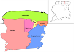
Map showing the resorts of Saramacca District.
  Jarikaba
Coordinates: 5°49′16″N55°19′49″W / 5.82111°N 55.33028°W / 5.82111; -55.33028
CountryFlag of Suriname.svg  Suriname
District Saramacca District
Area
  Total127 km2 (49 sq mi)
Population
 (2012) [1]
  Total5,963
  Density47/km2 (120/sq mi)
Time zone UTC-3 (AST)

Jarikaba is a resort in Suriname, located in the Saramacca District. Its population at the 2012 census was 5,963. [1] Bananas form the backbone of the economy. Food And Agriculture Industries, the main employer, has 1,200 hectares (3,000 acres) under cultivation, and a workforce of more than 1,000 people. [2] Food And Agriculture Industries used export only to Europe, but as of 2018 supplies much of the Caribbean. [3]

The Jarikaba Airstrip is located near Jarikaba. [4]

Related Research Articles

<span class="mw-page-title-main">Coronie District</span> District of Suriname

Coronie is a district of Suriname, situated on the coast. Coronie's capital city is Totness. The district border the Atlantic Ocean to the north, the Surinamese district of Saramacca to the east, the Surinamese district of Sipaliwini to the south and the Surinamese district of Nickerie to the west. The district is served by the Totness Airstrip.

<span class="mw-page-title-main">Para District</span> District of Suriname

Para is a district of northern Suriname. Para's capital city is Onverwacht, with other towns including Paranam, and Zanderij. Para has a population of 24,700 and an area of 5,393 km2. The district is the mining and forestry centre of Suriname, with many large bauxite mining operations operating. The district is a mixture of forest and savannas.

<span class="mw-page-title-main">Saramacca District</span> District of Suriname

Saramacca is a district of Suriname, in the north. Saramacca's capital city is Groningen, with other towns and cities including Batavia, Kampong Baroe, Uitkijk, Maho and Boskamp. Saramacca has a population of 17,480 and an area of 3,636 km2.

<span class="mw-page-title-main">Sipaliwini District</span> District of Suriname

Sipaliwini is the largest district of Suriname, located in the south. Sipaliwini is the only district that does not have a regional capital, as it is directly administered by the national government in Paramaribo.

<span class="mw-page-title-main">Moengo</span> Resort in Marowijne District, Suriname

Moengo is a town in Suriname, located in the Marowijne district, between Paramaribo and the border town Albina on the Cottica River. Moengo is also a resort (municipality) in the district of Marowijne. Moengo was the capital of Marowijne District between 1932 and 1945. The current capital is Albina.

<span class="mw-page-title-main">Totness, Suriname</span> Resort and town in Coronie District, Suriname

Totness is a town in Suriname, located in the Coronie district, of which it is the capital. Totness is the oldest settlement in the district.

<span class="mw-page-title-main">Lelydorp</span> Resort and town in Wanica District, Suriname

Lelydorp is the capital city of Wanica District, located in Suriname. With a population of 18,663 (2012), it is the second largest city in Suriname, after Paramaribo.

<span class="mw-page-title-main">Meerzorg</span> Resort in Commewijne District, Suriname

Meerzorg is a town and resort (municipality) in Suriname, located on the eastern bank of the Suriname River, directly opposite the capital Paramaribo. Its population at the 2012 census was 12,405. Since 2000 it has been connected to Paramaribo by the Jules Wijdenbosch Bridge, named after the former President Jules Wijdenbosch.

<span class="mw-page-title-main">Sarakreek</span> Resort in Brokopondo District, Suriname

Sarakreek is a resort in the gold mining region of Brokopondo District in Suriname. Its population at the 2012 census was 3,076. It is served by the Sarakreek Airstrip. The resort is named after the eponymous creek.

<span class="mw-page-title-main">Groot Henar</span> Resort in Nickerie District, Suriname

Groot Henar is a resort in Suriname, located in the Nickerie District, near the bridge over the Nickerie River. Its population at the 2012 census was 2,709, most of which are East Indian. The resort has been named after the plantation Henar which was turned into small agricultural plots after the abolition of slavery. The cultivatable area was increased with the Henarpolder created in the 1920s. 1970 the Europolder was created adding 3,700 hectares to the resort.

<span class="mw-page-title-main">Noord, Suriname</span> Resort in Para District, Suriname

Noord is a resort in Suriname, located in the Para District. Its population at the 2012 census was 9,703. Noord is mainly an agricultural area, and has a school.

<span class="mw-page-title-main">Zuid, Suriname</span> Resort in Para District, Suriname

Zuid is a resort in Suriname, located in the Para District. Its population at the 2012 census was 6,113. The main ethnic groups are indigenous, Creoles, and mixed race.

<span class="mw-page-title-main">Beekhuizen</span> Resort in Paramaribo District, Suriname

Beekhuizen is a former sugarcane plantation and currently a resort in Suriname, located in the Paramaribo District. Its population at the 2012 census was 17,185.

<span class="mw-page-title-main">Kabalebo</span> Resort in Sipaliwini District, Suriname

Kabalebo is a resort in Suriname, located in the Sipaliwini District. Its population at the 2012 census was 2,291.

<span class="mw-page-title-main">Boven Suriname</span> Resort in Sipaliwini District, Suriname

Boven Suriname is a resort in Suriname, located in the Sipaliwini District. Its population at the 2012 census was 17,954. Almost its entire population consists of Maroons

<span class="mw-page-title-main">Boven Saramacca</span> Resort in Sipaliwini District, Suriname

Boven Saramacca is a resort in Suriname, located in the Sipaliwini District. Its population at the 2012 census was 1,427. The dominant geographical feature of this resort is the Saramacca River. The resort is mainly inhabited by Maroons of the Matawai tribe.

<span class="mw-page-title-main">Tijgerkreek</span> Resort in Saramacca District, Suriname

Tijgerkreek is a resort in Suriname, located in the Saramacca District. Its population at the 2012 census was 3,244, the majority being Javanese, and East Indian. The resort is mainly agricultural. In the 21st century, there has been an emphasis on peanuts. The development of a modern agricultural centre is being planned.

Bakhuys is a village in the Kabalebo resort of the Sipaliwini District in Suriname. The village is located near the Bakhuis Mountains. Bakhuis is mainly known for its large bauxite mine which is exploited by Suralco. In 1995, the refinery had received a $120 million upgrade and extension. The village and mountain range have been named after Louis August Bakhuis who led a 1901 expedition into the area.

<span class="mw-page-title-main">Pamacca</span> Resort in the Sipaliwini District of Suriname

Paramacca is a resort in Suriname, located in the Sipaliwini District. The population is estimated between 1,500 and 2,000 people. In 1983, the Sipaliwini District was created, and the eastern part became the resort of Tapanahony. The Paramacca resort is the northern part of Tapanahony, and mainly inhabited by the Paramaccan people, the border of the resorts is the island of Bofoo Tabiki in the Marowijne River.

<span class="mw-page-title-main">Pikin Slee</span> Place in Sipaliwini, Suriname

Pikin Slee is a village on the Suriname River in the resort Boven Suriname of the Sipaliwini District. It is home to about 3,000 people, and the second largest village of the Saramaka Maroons, after Aurora.

References

  1. 1 2 "Resorts in Suriname Census 2012" (PDF). Retrieved 26 May 2020.
  2. "Bananenproductie Jarikaba komt op gang". GFC Nieuws (in Dutch). Retrieved 27 May 2020.
  3. "Jarikaba in de bloei". De Boodschap.today. Retrieved 27 May 2020.
  4. "Jarikaba Airstrip Airport". Airport Guide. Retrieved 4 January 2022.