 |
|---|
| Constitution |
Suriname is divided into 10 districts (Dutch : districten).
| |
|---|
| Constitution |
Suriname is divided into 10 districts (Dutch : districten).

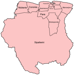
| District | Capital | Area (km2) | Area (%) | Population (2012 census) [1] | Population (%) | Pop. dens. (inhabitants/km2) | |
|---|---|---|---|---|---|---|---|
| Suriname | Paramaribo | 163,820 | 100.0 | 541,638 | 100.0 | 3.3 | |
| 1 | Brokopondo | Brokopondo | 7,364 | 4.5 | 15,909 | 2.9 | 2.2 |
| 2 | Commewijne | Nieuw-Amsterdam | 2,353 | 1.4 | 31,420 | 5.8 | 13.4 |
| 3 | Coronie | Totness | 3,902 | 2.2 | 3,391 | 0.6 | 0.9 |
| 4 | Marowijne | Albina | 4,627 | 2.8 | 18,294 | 3.4 | 4.0 |
| 5 | Nickerie | Nieuw-Nickerie | 5,353 | 3.3 | 34,233 | 6.3 | 6.4 |
| 6 | Para | Onverwacht | 5,393 | 3.3 | 24,700 | 4.6 | 4.6 |
| 7 | Paramaribo | Paramaribo | 182 | 0.1 | 240,924 | 44.5 | 1323.8 |
| 8 | Saramacca | Groningen | 3,636 | 2.2 | 17,480 | 3.2 | 4.8 |
| 9 | Sipaliwini | none | 130,567 | 79.7 | 37,065 | 6.8 | 0.3 |
| 10 | Wanica | Lelydorp | 443 | 0.3 | 118,222 | 21.8 | 266.9 |
The country was first divided up into subdivisions by the Dutch on October 8, 1834, when a Royal Decree declared that there were to be 8 divisions and 2 districts: [2]
The divisions were areas near the capital city, Paramaribo, and the districts were areas further away from the city.
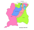


In 1927, Suriname's districts were revised, and the country was divided into 7 districts. In 1943, 1948, 1949, 1952 and 1959 further small modifications were made. In 1968 the districts were redrawn again, into [3]
These divisions remained until 1980, when yet again, the borders of the districts were redrawn, however, with the following requirements:
The last changes to the districts were in 1985. [3]
| Brokopondo District |  | |
|---|---|---|
| Commewijne District | ||
| Coronie District | ||
| Marowijne District | ||
| Nickerie District | ||
| Para District | ||
| Paramaribo District | ||
| Saramacca District | ||
| Sipaliwini District | ||
| Wanica District | ||
| | This Suriname location article is a stub. You can help Wikipedia by expanding it. |