Commewijne District

Last updated
Commewijne
Overzicht van district Commewijne - Unknown - 20418727 - RCE.jpg
Vlag Commewijne.png
Commewijne in Suriname (+claims).svg
Map of Suriname showing Commewijne district
Coordinates: 5°52′N55°04′W / 5.867°N 55.067°W / 5.867; -55.067
Country Suriname
Capital Nieuw Amsterdam
Area
  Total2,353 km2 (908 sq mi)
Population
 (2012 census) [1]
  Total31,420
  Density13/km2 (35/sq mi)
Time zone UTC-3

Commewijne is a district of Suriname, located on the right bank of the Suriname River. Commewijne's capital city is Nieuw Amsterdam. Tamanredjo is another major town, while Meerzorg is the most populated. [1]

Contents

The district has a population of 31,420 and an area of 2,353 km2. [1]

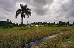
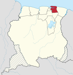
One of the most populated of Suriname's districts, Commewijne relies primarily on agriculture for its income, with plantations dating back to the first Dutch colonisation of the area in the 17th century. [2] In the 21st century, Meerzorg has been designated as a regional centre, and suburban area for Paramaribo, and is the site of many building projects. Nieuw Amsterdam has been steadily growing as well. [3]

History

In 1621, the Dutch West India Company started to explore the Guianas, and traded with the indigenous people. When a force reporting to Francis Willoughby landed on Commewijne, there was already a small Dutch settlement who were trading with the indigenous people, and a group of Jews had arrived in Suriname in 1632. Surinam was conquered in 1667 by Abraham Crijnssen for the Dutch West India Company. [4] Commewijne became the main location for plantations during the 18th century. [2] A monument to the independence of Suriname is located in Fort Nieuw-Amsterdam. [5]

Forts

Fort Nieuw-Amsterdam is located in Nieuw Amsterdam. On 10 October 1712, Jacques Cassard captured the plantation Meerzorg for France, and threatened Paramaribo across the Suriname river. [6] To protect Paramaribo and Commewijne from future attacks, Fort Nieuw-Amsterdam was constructed, and opened in 1747. [7]

Several other small colonial forts were constructed. The redoubts Frederiksdorp, Braamspunt, and Leiden were the first towns connected to a telephone line after Paramaribo to Nieuw-Amsterdam in 1888. [8] The scale of the other forts was small, because when August Kappler visited Frederiksdorp in 1854, three soldiers were stationed there. [9]

Resorts

Resorts of Commewijne Commewijne Resorts Suriname Neutral.png
Resorts of Commewijne

Commewijne is divided into 6 resorts (ressorten):

Villages

Nature and tourism

The Braamspunt Nature Reserve is located in Commewijne, because it is an important nesting ground for the leatherback sea turtles, and the green sea turtles. [10]

The former plantation of Frederiksdorp is located near Johan & Margaretha, and has in 2004 been designated at as a monument. [11]

Transport

Commewijne used to be isolated from Paramaribo, In 1931, a ferry opened between Meerzorg en Paramaribo, [12] but to improve access to the eastern part of Suriname, the Jules Wijdenbosch Bridge was opened on 20 May 2000 replacing the ferry. The bridge is part of the East-West Link. [13]

In 2020, plans were announced to build a bridge between Laarwijk and Domburg in order to develop the area, and relieve traffic congestion between Wanica and Commewijne. [14]

Economy

The economy is still largely built around agriculture, and the industry in the district are mainly related to agriculture as well. [3] The closure of the sugarcane factory Mariënburg in 1986 caused a regional decline. [15] Meerzorg is becoming a centre for trade. Companies and banks have started to open offices or moved to the town. [3]

Related Research Articles

<span class="mw-page-title-main">Marowijne District</span> District of Suriname

Marowijne is a district of Suriname, located on the north-east coast. Marowijne's capital city is Albina, with other towns including Moengo and Wanhatti. The district borders the Atlantic Ocean to the north, French Guiana to the east, the Surinamese district of Sipaliwini to the south, and the Surinamese districts of Commewijne and Para to the west.

<span class="mw-page-title-main">Wanhatti</span> Resort in Marowijne District, Suriname

Wanhatti is a village and resort in Suriname, located in the Marowijne district on the Cottica River. The resort is inhabited by the Ndyuka Maroons, and has a population of 468 people as of 2012. The village is primarily inhabited by Ndyuka of the Ansu clan or lo.

<span class="mw-page-title-main">Lelydorp</span> Resort and town in Wanica District, Suriname

Lelydorp is the capital city of Wanica District, located in Suriname. With a population of 18,663 (2012), it is the second largest city in Suriname, after Paramaribo.

<span class="mw-page-title-main">Nieuw Amsterdam, Suriname</span> Resort and town in Commewijne District, Suriname

Nieuw Amsterdam is the capital of the Commewijne District in Suriname. It is a small coastal town situated at the confluence of the Suriname River and Commewijne River, just across from Paramaribo, the country's capital. Its population at the 2012 census was 5,650, with around 1,200 people living in the main town, most of whom are of Javanese and East Indian origin. It is the location of the historical Fort Nieuw-Amsterdam, today an open-air museum. The town of Mariënburg with former sugarcane factory is located 3 km from Nieuw Amsterdam and part of the resort.

<span class="mw-page-title-main">Suriname River</span> River in Suriname

The Suriname River is 480 km long and flows through the country of Suriname. Its sources are located in the Guiana Highlands on the border between the Wilhelmina Mountains and the Eilerts de Haan Mountains. The source of the Upper Suriname River is at the confluence of the Gran Rio and Pikin Rio near the village of Goddo. The river continues shortly after the reservoir along Brokopondo as the Lower Suriname River. Than it flows Berg en Dal, the migrant communities Klaaskreek and Nieuw-Lombé, Jodensavanne, Carolina, Ornamibo and Domburg, before reaching the capital Paramaribo on the left bank and Meerzorg on the right bank. At Nieuw-Amsterdam it is joined by the Commewijne and immediately thereafter at the sandspit Braamspunt it flows into the Atlantic Ocean.

Laarwijk is a settlement and a former sugar plantation in the Commewijne District in Suriname. Laarwijk is situated along the Suriname River and can only be reached by boat.

<span class="mw-page-title-main">Meerzorg</span> Resort in Commewijne District, Suriname

Meerzorg is a town and resort (municipality) in Suriname, located on the eastern bank of the Suriname River, directly opposite the capital Paramaribo. Its population at the 2012 census was 12,405. Since 2000 it has been connected to Paramaribo by the Jules Wijdenbosch Bridge, named after the former President Jules Wijdenbosch.

<span class="mw-page-title-main">Alkmaar, Suriname</span> Resort and town in Commewijne District, Suriname

Alkmaar is a resort in Suriname, located in the Commewijne District. Its population at the 2012 census was 5,561.

<span class="mw-page-title-main">Johan & Margaretha</span> Resort in Commewijne District, Suriname

Johan & Margaretha or sometimes just Margaretha is a resort in Suriname, located in the Commewijne District. Its population at the 2012 census was 756. It is located along a peninsula northeast of Paramaribo. It is named after the coffee plantation Johan & Margaretha which was founded in 1745 by Johan Knöffel. It is safe to assume that his wife was called Margaretha.

<span class="mw-page-title-main">Tamanredjo</span> Resort and town in Commewijne District, Suriname

Tamanredjo is a resort and town in Suriname, located in the Commewijne District. Its population at the 2012 census was 6,601.

<span class="mw-page-title-main">Domburg, Suriname</span> Resort in Wanica District, Suriname

Domburg is a resort in the Wanica District of Suriname, located on the northern coast of South America. Its population at the 2012 census was 5,661.

<span class="mw-page-title-main">Centrum, Paramaribo</span> Resort in Paramaribo District, Suriname

Centrum is a resort in Suriname, located in the Paramaribo District. Its population at the 2012 census was 20,631. The historical centre of Paramaribo is located within the resort. The city centre is mainly in original condition, contains 291 listed monuments, and has of 2002 been designated a UNESCO World Heritage Site.

<span class="mw-page-title-main">Marienburg, Suriname</span> Place in Commewijne District, Suriname

Mariënburg is a former sugarcane plantation, factory and village, situated in the district of Commewijne, in northern Suriname.

<span class="mw-page-title-main">Fort Nieuw-Amsterdam</span> Fort near Nieuw-Amsterdam, Suriname

Fort Nieuw-Amsterdam is a fort in Suriname built from 1734 to 1747 at the confluence of the Suriname and Commewijne rivers. It is open to the public as an open-air museum.

<span class="mw-page-title-main">Braamspunt</span> Nature reserve and village in Commewijne District, Suriname

Braamspunt is a nature reserve, fishing village, and a former military outpost in the Johan & Margaretha resort of the Commewijne District of Suriname. Braamspunt is the most western point of the Commewijne District at the combined mouth of the Suriname and Commewijne River. The capital Paramaribo is located to the south of Braamspunt. The name is a corruption of Byam's Point which refers William Byam who was a quartermaster of Willoughby.

<span class="mw-page-title-main">Ferry terminal Leonsberg</span> Ferry jetty in Suriname

The Ferry terminal Leonsberg is a ferry jetty in the north of Paramaribo, Suriname. From here various private operators offer transport service the other side of the Suriname river and the Commewijne River.

<span class="mw-page-title-main">Johannes Cateau van Rosevelt</span> Dutch navy officer and civil servant

Johannes François Adriaan Cateau van Rosevelt was a Dutch navy officer and civil servant in Suriname where he was, among other things, agent-general for immigration and a member of the Colonial Estates of Suriname. He is known for his map of Suriname.

<span class="mw-page-title-main">Waterkant</span> Street in Paramaribo, Suriname

The Waterkant is the oldest and one of the most important streets of Paramaribo, Suriname. The street is located in the historic centre on the Suriname River, and was the location where ships used to arrive. The street starts at the Onafhankelijkheidsplein and extends to the Central Market. As of 2002, it has been designated a Unesco World Heritage Site.

<span class="mw-page-title-main">Fort Sommelsdijk</span> Fort in Suriname

Fort Sommelsdijk was a fort in Suriname built in 1686 at the confluence of the Commewijne and Cottica rivers. Later it was used as a mission post and hospital. In 1870, it lost its function and was only used a military outpost. In the 21st century, the fort was taken over by nature.

References

  1. 1 2 3 "2012 Census Resorts Suriname" (PDF). Spang Staging. Retrieved 11 May 2020.
  2. 1 2 "Distrikt Commewijne 1". Suriname.nu (in Dutch). Retrieved 25 May 2020.
  3. 1 2 3 "Structuur Analyse" (PDF). Planning Office Suriname (in Dutch). Retrieved 25 May 2020.
  4. "Encyclopaedie van Nederlandsch West-Indië - Page 343 - Handel en Scheepvaart" (PDF). Digital Library for Dutch Literature (in Dutch). 1916. Retrieved 9 May 2020.
  5. "Monumenten in Suriname 4". Suriname.nl (in Dutch). Retrieved 25 May 2020.
  6. Jan Jacob Hartsinck, Digital Library for Dutch Literature (1770). "Beschryving van Guiana, of de wilde kust in Zuid-America" (in Dutch).
  7. "Geschiedenis". Fort Nieuw Amsterdam (in Dutch). Retrieved 17 May 2020.
  8. "Encyclopaedie van Nederlandsch West-Indië - Page 587 - Telefonie" (PDF). Digital Library for Dutch Literature (in Dutch). 1916. Retrieved 9 May 2020.
  9. "Zes jaren in Suriname". Digital Library for Dutch Literature (in Dutch). 1854. Retrieved 25 May 2020.
  10. "Sea Turtles". Braamspunt.org. Retrieved 25 May 2020.
  11. "FREDERIKSDORP; HERLEVING VAN EEN LANG VERGANE GLORIETIJD". United News.sr (in Dutch). Retrieved 26 May 2020.
  12. "DE GESCHIEDENIS VAN MEERZORG, ZOALS BESCHREVEN IN OUDE KRANTENBERICHTEN, DEEL 1 (1915-1940)". Plantage Jaglust (in Dutch). Retrieved 25 May 2020.
  13. "Infrastructuur". En Toen.nu (in Dutch). Retrieved 25 May 2020.
  14. "PL wil met brug Domburg-Laarwijk landbouw ontwikkelingen". Star Nieuws (in Dutch). Retrieved 25 May 2020.
  15. "1901 AD - 2000 AD Suriname in de 20e eeuw". Suriname.nu (in Dutch). Retrieved 25 May 2020.

5°52′11″N54°55′11″W / 5.86972°N 54.91972°W / 5.86972; -54.91972