Galibi | |
|---|---|
 View of Galibi beach | |
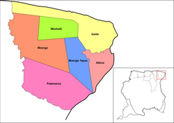 Map showing the resorts of Marowijne District. Galibi | |
| Coordinates: 5°41′52″N54°01′40″W / 5.6978°N 54.0277°W | |
| Country | |
| District | Marowijne District |
| Area | |
• Total | 1,014 km2 (392 sq mi) |
| Elevation | 0 m (0 ft) |
| Population (2012) [1] | |
• Total | 741 |
| • Density | 0.73/km2 (1.9/sq mi) |
| Time zone | UTC-3 (AST) |
Galibi is a resort in Suriname, located in the Marowijne District. Its population at the 2012 census was 741. Galibi is a tribal area inhabited by an indigenous population [1] of Kalina Amerindians. [2]
Contents
- Christiaankondre
- Langamankondre
- Galibi Nature Reserve
- Wia Wia Nature Reserve
- Transport
- Notable people
- Sister cities
- Gallery
- Further reading
- See also
- References
- External links
The town of Alusiaka used to be located near the banks of the Marowijne River. The Dutch West India Company was given 500 hectares to grow coconuts; but, because of their mistreatment of the workers, the town was abandoned. [3] In 1871 a 60-metre lighthouse was built near the entrance of the Marowijne; it was operated until 2012. [4]


