
As part of the foreign relations of Suriname, the country is a participant in numerous international organizations.

Paramaribo is the capital and largest city of Suriname, located on the banks of the Suriname River in the Paramaribo District. Paramaribo has a population of roughly 241,000 people, almost half of Suriname's population. The historic inner city of Paramaribo has been a UNESCO World Heritage Site since 2002.
Suriname is divided into 10 districts.

Sipaliwini is the largest district of Suriname, located in the south. Sipaliwini is the only district that does not have a regional capital, as it is directly administered by the national government in Paramaribo.

The Aluku are a Bushinengue ethnic group living mainly on the riverbank in Maripasoula in southwest French Guiana. The group are sometimes called Boni, referring to the 18th-century leader, Bokilifu Boni.

Totness is a town in Suriname, located in the Coronie district, of which it is the capital. Totness is the oldest settlement in the district.

Wanhatti is a village and resort in Suriname, located in the Marowijne district on the Cottica River. The resort is inhabited by the Ndyuka Maroons, and has a population of 468 people as of 2012. The village is primarily inhabited by Ndyuka of the Ansu clan or lo.

Commewijne River is a river in northern Suriname.

Cottica Lawa is a village in the district of Sipaliwini, Suriname. It is located in the east, along the Marowijne River and the border with French Guiana. The village has a school, and a clinic.

Benzdorp is a village in the Sipaliwini District of Suriname. It is named after the English consul and bullion dealer H.J.W. Benz.

Meerzorg is a town and resort (municipality) in Suriname, located on the eastern bank of the Suriname River, directly opposite the capital Paramaribo. Its population at the 2012 census was 12,405. Since 2000 it has been connected to Paramaribo by the Jules Wijdenbosch Bridge, named after the former President Jules Wijdenbosch.
The (northern) East-West Link is a road in Suriname between Albina in the eastern part of the country to Nieuw Nickerie in the western part, via the capital city of Paramaribo. The southern East-West Link connects Paramaribo with Apoera via Bitagron. Construction of the road link started in the 1960s.

The Ndyuka people or Aukan people (Okanisi), are one of six Maroon peoples in the Republic of Suriname and one of the Maroon peoples in French Guiana. The Aukan or Ndyuka speak the Ndyuka language. They are subdivided into the Opu, who live upstream of the Tapanahony River in the Tapanahony resort of southeastern Suriname, and the Bilo, who live downstream of that river in Marowijne District

Pinatjaimi, also spelled as Pinatyaimi, is a Ndyuka Maroon village on the Cottica River in Suriname.
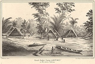
Lantiwei, also spelled as Lantiwee and Lantiwé, is a Ndyuka Maroon village on the Cottica River in Suriname. Lantiwei lies opposite the village of Pinatjaimi, with Lantiwei being the village the people of Pinatjaimi originated from.

Pikin Santi, sometimes spelt as Pikien Santi, is a Ndyuka village on the Cottica River in Suriname inhabited by the Pinasi and Piika lo. Pikin Santi is situated upstream from Pinatjaimi and Lantiwei, and downstream from Tamarin. It lies in the vicinity of the Buku creek and should therefore be close to the ruins Fort Buku, which as of yet have not been identified.

The Lawa Railway was a 173-kilometre-long single-track metre gauge railway in Suriname. It was built during the gold rush in the early 20th century, from the harbour town Paramaribo to Dam at the Sara Creek, but it was not extended to the gold fields at the Lawa River, as originally intended.

Powakka is an indigenous village of Lokono Amerindians in the resort of Oost in the Para District in Suriname. The village is located on the road to Carolina which connects to the Afobakaweg to Paramaribo.

Ronald "Rudi" Elwin Kappel was a Surinamese pilot. He was one of the founders of Luchtvaartbedrijf Kappel-Van Eyck which is now called Surinam Airways, the first airline in Suriname. He also helped construct the Zorg en Hoop Airport, and the Rudi Kappel Airstrip. Kappel died in an air crash near Paloemeu.

Fort Sommelsdijk was a fort in Suriname built in 1686 at the confluence of the Commewijne and Cottica rivers. Later it was used as a mission post and hospital. In 1870, it lost its function and was only used a military outpost. In the 21st century, the fort was taken over by nature.

