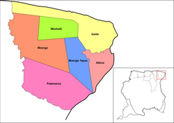
Marowijne is a district of Suriname, located on the north-east coast. Marowijne's capital city is Albina, with other towns including Moengo and Wanhatti. The district borders the Atlantic Ocean to the north, French Guiana to the east, the Surinamese district of Sipaliwini to the south, and the Surinamese districts of Commewijne and Para to the west.

The Saramaka, Saamaka or Saramacca are one of six Maroon peoples in the Republic of Suriname and one of the Maroon peoples in French Guiana. In 2007, the Saramaka won a ruling by the Inter-American Court for Human Rights supporting their land rights in Suriname for lands they have historically occupied, over national government claims. It was a landmark decision for indigenous peoples in the world. They have received compensation for damages and control this fund for their own development goals.

The Aluku are a Bushinengue ethnic group living mainly on the riverbank in Maripasoula in southwest French Guiana. The group are sometimes called Boni, referring to the 18th-century leader, Bokilifu Boni.

The Paramaccan or Paramaka are a Maroon tribe living in the forested interior of Suriname, mainly in the Paramacca resort, and the western border area of French Guiana. The Paramaccan signed a peace treaty in 1872 granting the tribe autonomy.
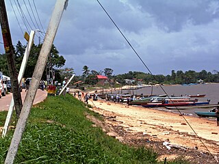
Albina is a town in eastern Suriname, and is capital of the Marowijne District. The town lies on the west bank of the Marowijne river, which forms the border with French Guiana, directly opposite the French Guianan town of Saint-Laurent-du-Maroni, to which it is connected by a frequent ferry service. Albina can be reached by bus via the East-West Link. The distance between Paramaribo and Albina is about 150 kilometres (95 mi).

Cottica Lawa is a village in the district of Sipaliwini, Suriname. It is located in the east, along the Marowijne River and the border with French Guiana. The village has a school, and a clinic.

Tapanahoni is a resort in Suriname, located in the Sipaliwini District. Its population at the 2012 census was 13,808. Tapanahoni is a part of Sipaliwini which has no capital, but is directly governed from Paramaribo. Tapanahony is an enormous resort which encompasses a quarter of the country of Suriname. The most important town is Diitabiki which is the residence of the granman of the Ndyuka people since 1950, and the location of the oracle.

Papaichton is a commune in the overseas region and department of French Guiana. The village lies on the shores of the Lawa River. Papaichton is served by the Maripasoula Airport.

The Ndyuka people or Aukan people (Okanisi), are one of six Maroon peoples in the Republic of Suriname and one of the Maroon peoples in French Guiana. The Aukan or Ndyuka speak the Ndyuka language. They are subdivided into the Opu, who live upstream of the Tapanahony River in the Tapanahony resort of southeastern Suriname, and the Bilo, who live downstream of that river in Marowijne District

Pinatjaimi, also spelled as Pinatyaimi, is a Ndyuka Maroon village on the Cottica River in Suriname.
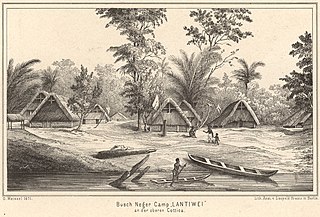
Lantiwei, also spelled as Lantiwee and Lantiwé, is a Ndyuka Maroon village on the Cottica River in Suriname. Lantiwei lies opposite the village of Pinatjaimi, with Lantiwei being the village the people of Pinatjaimi originated from.

Pikin Santi, sometimes spelt as Pikien Santi, is a Ndyuka village on the Cottica River in Suriname inhabited by the Pinasi and Piika lo. Pikin Santi is situated upstream from Pinatjaimi and Lantiwei, and downstream from Tamarin. It lies in the vicinity of the Buku creek and should therefore be close to the ruins Fort Buku, which as of yet have not been identified.
Hendrik Ulbo Eric"Bonno"Thoden van Velzen was a Dutch anthropologist, Surinamist and Africanist.
Wilhelmina (Ineke) van Wetering was a Dutch anthropologist and Surinamist. She was born on 17 October 1934 in the Dutch city of Hilversum. When she was 10 years old, her father (ironmonger) had been executed by firing squad in the Second world war because of participating in an illegal group who provided hiding places for people who were prosecuted by the Nazi-German army. She finished her secondary school in 1955, when she began her study of sociology at the University of Amsterdam. In her later career she continued her work at the Vrije Universiteit Amsterdam.

Diitabiki is a Ndyuka village in the Sipaliwini District of Suriname. Diitabiki is the residence of the gaanman of the Ndyuka people, since 1950, and the location of the oracle.
The Lely Mountains are a mountain plateau on the left bank of the Tapanahony and Marowijne rivers in Suriname. The plateau has a maximum altitude of about 685 metres (2,247 ft). In 2005, 25 new species were discovered in the Lely Mountains.

Granman is the title of the paramount chief of a Maroon nation in Suriname and French Guiana. The Ndyuka, Saramaka, Matawai, Aluku, Paramaka and Kwinti nations all have a granman. The paramount chiefs of Amerindian peoples in Suriname are nowadays also often called granman.
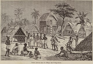
Bokilifu Boni was a freedom fighter and guerrilla leader in Suriname, when it was under Dutch colonial rule. Born in Cottica to an enslaved African mother who escaped from her Dutch master, he grew up with her among the Maroons in the forest. He was such a powerful leader that his followers were known as Boni's people after him. They built a fort in the lowlands and conducted raids against Dutch plantations along the coast. Under pressure from Dutch regular army and hundreds of freedmen, they went east across the river into French Guiana. Boni continued to conduct raids from there, but was ultimately killed in warfare.

Tebutop is a mountain in Suriname at 374 metres (1,227 ft). It is located in the Sipaliwini District.
Poeloegoedoe is a village in the Tapanahony River at the confluence with the Lawa River. It is named after the Poeloegoedoe Falls and is inhabitated by maroons of the Ndyuka people. The village is located in the Tapanahony resort of Sipaliwini District, Suriname.