East-West Link (Suriname)

Last updated
East-West Link
Major junctions
West end Nieuw Nickerie
East end Albina
Location
Country Suriname
Highway system

The (northern) East-West Link (Dutch: Oost-Westverbinding) is a road in Suriname between Albina in the eastern part of the country to Nieuw Nickerie in the western part, via the capital city of Paramaribo. The southern East-West Link connects Paramaribo with Apoera via Bitagron. Construction of the road link started in the 1960s.

Contents

Overview

Overview of the East-West Link
.mw-parser-output .legend{page-break-inside:avoid;break-inside:avoid-column}.mw-parser-output .legend-color{display:inline-block;min-width:1.25em;height:1.25em;line-height:1.25;margin:1px 0;text-align:center;border:1px solid black;background-color:transparent;color:black}.mw-parser-output .legend-text{}
Northern East-West Link
Southern East-West Link
Jeep trail between South Drain and Apoera. East-West Link.png
Overview of the East-West Link
  Northern East-West Link
  Southern East-West Link
  Jeep trail between South Drain and Apoera.

Bridges

In recent years, various ferries on the East-West Link route have been replaced with bridges. There is a bridge near Groot Henar spanning the Nickerie River. In 1980, a bridge was built on the Commewijne River near Stolkertsijver. Since 1999, the Coppename Bridge connects Jenny with Boskamp, and since 2000 the Jules Wijdenbosch Bridge connects Paramaribo with Meerzorg. On the southern East-West Link, bailey bridges spanning the Coppename River and Nickerie River were built near Bitagron and Kamp 52 respectively.

The bridge spanning the Saramacca River between Hamburg and Uitkijk was opened on 25 June 2011. [1]

Reconstruction

The road is in a bad state on several parts of the route, partly due to damage because of the Suriname Guerrilla War. Various revitalization projects have been started.
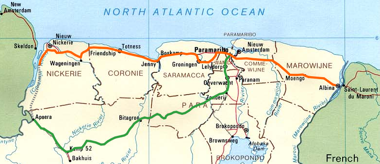
A 32-kilometre-long section between Nieuw Nickerie and the ferry near South Drain was not paved until recently. The European Union funded the reconstruction, which started in 2007, with 13.2 million euro. [2] [3] The section was due to be completed in the first quarter of 2010. [4]

There is a jeep trail between South Drain and Apoera, connecting the Northern East-West Link with the Southern East-West Link. Contrary to earlier plans, the pavement of this road is not imminent. [5]

The eastern part of the East-West Link, that is the section between Meerzorg and Albina, is being repaved with funds from the European Union, the Agence française de développement and the Inter-American Development Bank. In August 2009, a Project Executing Unit (PEU) was installed, whose task it is to safeguard quality guidelines, project planning, and the total budget of USD 140 million. The project entails a total section of 138 kilometres and the rehabilitation is planned to be finished in 30 months’ time. The reconstruction will adhere to the standards of the Initiative for the Integration of the Regional Infrastructure of South America (IIRSA). [6] [7] [8]

In March 2010, the Dutch company MNO Vervat was to begin repaving the road between Tamanredjo (km 20,5) and Moengo (km 95). The section between Moengo and Albina (km 138) will be repaved by the Chinese company Dalian. The tender for the section between Meerzorg (km 0) and Tamanredjo will be put out in 2011. The road will be widened in several places and cycling lanes will be added in built-up areas. [9]

Suriname aims for reconstructing the Southern East-West Link (Paramaribo-Zanderij-Bitagron-Apoera) between 2010 and 2015. [10] In the IIRSA project, this road is part of Group 3 of the Guyana Shield Hub region, which links Ciudad Guayana in Venezuela via San Martín de Turumbang, Linden and Apoera with Paramaribo. The project includes the building of a bridge on the Courantyne River between Apoera and Orealla in Guyana. [11] [12] According to a study by Pitou van Dijk, the Linden-Paramaribo section has only secondary priority with IIRSA at the moment. [13]

Connections with neighbouring countries

The East-West Link has a ferry connection with Guyana on the western side since 1998, connecting South Drain with Moleson Creek. [14] In the east there has been a ferry between Albina and Saint-Laurent-du-Maroni in French Guiana since 1969.

Within the framework of the IIRSA, the Suriname Planning Bureau has done some studies on the incorporation of the East-West Link in the Pan-American Highway. Suriname has been part of the Pan-American Highway project since 1982. Apart from the reconstruction of the East West Link as described above, a feasibility study has been started for a bridge between Suriname and French Guiana. [15] [16] Also a North-South Link connecting Suriname with Brazil via the Vier Gebroeders mountains is being considered. [10]

See also

Related Research Articles

The transport sector comprises the physical infrastructure, docks and vehicle, terminals, fleets, ancillary equipment and service delivery of all the various modes of transport operating in Guyana. The transport services, transport agencies providing these services, the organizations and people who plan, build, maintain, and operate the system, and the policies that mold its development.

<span class="mw-page-title-main">Transport in Suriname</span>

The Republic of Suriname has a number of forms of transport. Transportation emissions are an increasing part of Suriname's contributions to climate change, as part of the Nationally Determined Contributions for the Paris Agreement, Suriname has committed to emissions controls for vehicles and increased public transit investment.

<span class="mw-page-title-main">Commewijne District</span> District of Suriname

Commewijne is a district of Suriname, located on the right bank of the Suriname River. Commewijne's capital city is Nieuw Amsterdam. Tamanredjo is another major town, while Meerzorg is the most populated.

<span class="mw-page-title-main">Marowijne District</span> District of Suriname

Marowijne is a district of Suriname, located on the north-east coast. Marowijne's capital city is Albina, with other towns including Moengo and Wanhatti. The district borders the Atlantic Ocean to the north, French Guiana to the east, the Surinamese district of Sipaliwini to the south, and the Surinamese districts of Commewijne and Para to the west.

<span class="mw-page-title-main">Nickerie District</span> District of Suriname

Nickerie is a district of Suriname, on the north-west coast. Nickerie's capital city is Nieuw-Nickerie. Another town is Wageningen. The district borders the Atlantic Ocean to the north, the Surinamese district of Coronie to the east, the Surinamese district of Sipaliwini to the south and the region of East Berbice-Corentyne in Guyana to the west.

<span class="mw-page-title-main">Sipaliwini District</span> District of Suriname

Sipaliwini is the largest district of Suriname, located in the south. Sipaliwini is the only district that does not have a regional capital, as it is directly administered by the national government in Paramaribo. Sipaliwini District includes disputed areas, with the southwestern region controlled and administered by Guyana, whereas the southeastern region is controlled by French Guiana.

<span class="mw-page-title-main">Albina, Suriname</span> Place in Marowijne District, Suriname

Albina is a town in eastern Suriname, and is capital of the Marowijne District. The town lies on the west bank of the Marowijne river, which forms the border with French Guiana, directly opposite the French Guianan town of Saint-Laurent-du-Maroni, to which it is connected by a frequent ferry service. Albina can be reached by bus via the East-West Link. The distance between Paramaribo and Albina is about 150 kilometres (95 mi).

Corriverton is the easternmost town in Guyana. It lies at the mouth of the Corentyne River, opposite Nieuw Nickerie, Suriname, to which it is linked by ferry from South Drain.

<span class="mw-page-title-main">Coppename River</span> River in Coronie & Saramacca District, Suriname

The Coppename is a river in Suriname in the district of Sipaliwini, forming part of the boundary between the districts of Coronie and Saramacca.

<span class="mw-page-title-main">Apoera</span> Place in Sipaliwini District, Suriname

Apoera, also Apura, is a town in western Suriname. The village has a population of 777 people as of 2020. It is the final destination of the Southern East-West Link. 24 kilometres (15 mi) north-west on the other side of the Courantyne River lies the Guyanese village of Orealla. The village is home to the Lokono tribe, but has been westernized. Due to the influx of people of Guyana, the languages used are English, and Sranan Tongo. Dutch is rarely spoken and the native language has all but disappeared. According to the oral tradition, Apoera was founded around 1920 by the Gordon family.

Witagron is a Kwinti village in Suriname on the Coppename River at the crossing of the Southern East-West Link from Paramaribo to Apoera in West-Suriname.

<span class="mw-page-title-main">Zorg en Hoop Airport</span> International airport in Paramaribo, Suriname

Zorg en Hoop Airport is an airport serving general aviation in the city of Paramaribo, Suriname. It is 3 kilometres (1.9 mi) west of the Suriname River, between the city quarters of Zorg en Hoop and Flora.

The Initiative for the Integration of the Regional Infrastructure of South America (IIRSA) is a development plan to link South America's economies through new transportation, energy, and telecommunications projects.

<span class="mw-page-title-main">Meerzorg</span> Resort in Commewijne District, Suriname

Meerzorg is a town and resort (municipality) in Suriname, located on the eastern bank of the Suriname River, directly opposite the capital Paramaribo. Its population at the 2012 census was 12,405. Since 2000 it has been connected to Paramaribo by the Jules Wijdenbosch Bridge, named after the former President Jules Wijdenbosch.

<span class="mw-page-title-main">South Drain, Suriname</span> Village in Nickerie District, Suriname

South Drain, also Zuiddrain, is a town in western Suriname. Since the pavement of 32 kilometres (20 mi) road section to Nieuw Nickerie, it is the final destination of the northern East-West Link. The European Union funded the reconstruction, which started in 2007, with 13.2 million euro. The section was opened on 30 April 2010. There is a jeep trail between South Drain and Apoera, connecting the Northern East-West Link with the Southern East-West Link. Contrary to earlier plans, the pavement of this road is not imminent.

<span class="mw-page-title-main">Guyana–Suriname relations</span> Bilateral relations

Guyana – Suriname relations are the bilateral relations between Guyana and Suriname. Suriname has an embassy in Georgetown. Guyana has an embassy in Paramaribo. The Courentyne River makes up most of the border between the two countries.

<span class="mw-page-title-main">France–Suriname relations</span> Bilateral relations

Diplomatic relations between France and Suriname were established on 25 August 1976. Suriname and the French overseas department of French Guiana share a common border of 520 kilometres (320 mi). Suriname operates an embassy in Paris, a consulate in Cayenne, and an honorary consulate in Saint-Laurent-du-Maroni. France operates an embassy in Paramaribo, a consulate in Georgetown, Guyana, and an honorary consulate in Albina.

<span class="mw-page-title-main">Roads in Suriname</span>

There are several named highways in the country of Suriname.

References

  1. Kridenki.com - Brug uitkijk-Hamburg onder mega publieke belangstelling geopend Archived 2012-05-30 at archive.today
  2. Nickerie.net - Asfaltering weg naar South Drain
  3. Dagblad Suriname - Activiteiten asfaltering South Drain in volle gang
  4. De Ware Tijd - Weg South Drain na 29 maanden klaar
  5. De Ware Tijd - 'Nog geen asfaltering wegvak South Drain-Apoera'
  6. Suriname start studie wegherstel met hulp EU
  7. Dagblad Suriname - Contract Project van de Rehabilitatie van de Oost-Westverbinding getekend Archived 2010-05-26 at archive.today
  8. Agence Française de Développement - Surinam: rehabilitating the road linking Paramaribo to French Guiana Archived 2009-12-23 at the Wayback Machine
  9. Nospang.com - Herasfaltering deel Oost-Westverbinding Archived 2010-02-13 at the Wayback Machine
  10. 1 2 Stichting Planbureau Suriname - Moengo – Albina Knooppunten van de Pan-American Highway [ permanent dead link ]
  11. IIRSA.org - Guyana Shield Hub presentation Archived 2011-07-25 at the Wayback Machine
  12. IIRSA.org - Venezuela (Ciudad Guayana)-Guiana (Georgetown)-Suriname (Paramaribo) Road (1st Stage) Archived 2011-07-25 at the Wayback Machine
  13. Pitou van Dijk - The IIRSA Guyana Shield Hub: The Case of Suriname
  14. Ministerie van Transport, Communicatie en Toerisme - De Canawaima Ferry Service Incorporated Archived 2012-05-30 at archive.today
  15. IIRSA.org - Improvement of the Marowijne River International Crossing Archived 2011-07-25 at the Wayback Machine - project summary
  16. Indianfeelings.nl - Fusie Suriname en Franks Guyana?