The transport sector comprises the physical infrastructure, docks and vehicle, terminals, fleets, ancillary equipment and service delivery of all the various modes of transport operating in Guyana. The transport services, transport agencies providing these services, the organizations and people who plan, build, maintain, and operate the system, and the policies that mold its development.

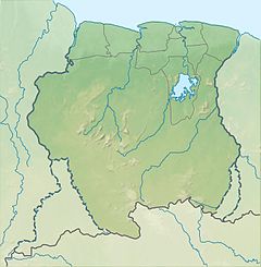
Suriname, officially the Republic of Suriname, is a country in northern South America, sometimes considered part of the Caribbean and the West Indies. Suriname is a developing country with a medium level of human development; its economy is heavily dependent on its abundant natural resources, namely bauxite, gold, petroleum, and agricultural products. Suriname is a member of the Caribbean Community (CARICOM), the United Nations, and the Organisation of Islamic Cooperation.
The Geography of Guyana comprises the physical characteristics of the country in Northern South America and part of Caribbean South America, bordering the North Atlantic Ocean, between Suriname and Venezuela, with a land area of approximately 214,969 square km. The country is situated between 1 and 9 north latitude and between 56 and 62 west longitude. With a 459 km (285 mi)-long Atlantic coastline on the northeast, Guyana is bounded by Venezuela on the west, Brazil on the west and south, and Suriname on the east.

Paramaribo is the capital and largest city of Suriname, located on the banks of the Suriname River in the Paramaribo District. Paramaribo has a population of roughly 241,000 people, almost half of Suriname's population. The historic inner city of Paramaribo has been a UNESCO World Heritage Site since 2002.
Commewijne is a district of Suriname, located on the right bank of the Suriname River. Commewijne's capital city is Nieuw Amsterdam. Tamanredjo is another major town, while Meerzorg is the most populated.
Marowijne is a district of Suriname, located on the north-east coast. Marowijne's capital city is Albina, with other towns including Moengo and Wanhatti. The district borders the Atlantic Ocean to the north, French Guiana to the east, the Surinamese district of Sipaliwini to the south, and the Surinamese districts of Commewijne and Para to the west.
The Jungle Commando was a guerrilla commando group in Suriname. It was founded by Ronnie Brunswijk in 1986 to ensure equal rights for Suriname's minority Maroon population. The group was formed after the Suriname troops committed mass murder against 35 people in Moiwana Village, near Moengo, after the Suriname national army failed to capture Ronnie Brunswijk. The Commando fought against Dési Bouterse and the Surinamese army in the Suriname Guerrilla War.

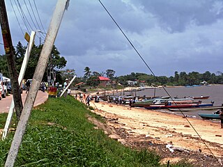
Moengo is a town in Suriname, located in the Marowijne district, between Paramaribo and the border town Albina on the Cottica River. Moengo is also a resort (municipality) in the district of Marowijne. Moengo was the capital of Marowijne District between 1932 and 1945. The current capital is Albina.

Johan Adolf Pengel International Airport, also known as Paramaribo-Zanderij International Airport, and locally referred to simply as JAP, is an airport located in the town of Zanderij and hub for airline carrier Surinam Airways, 45 kilometres (28 mi) south of Paramaribo. It is the larger of Suriname's two international airports, the other being Zorg en Hoop with scheduled flights to Guyana, and is operated by Airport Management, Ltd./ NV Luchthavenbeheer.

Nieuw Amsterdam is the capital of the Commewijne District in Suriname. It is a small coastal town situated at the confluence of the Suriname River and Commewijne River, just across from Paramaribo, the country's capital. Its population at the 2012 census was 5,650, with around 1,200 people living in the main town, most of whom are of Javanese and East Indian origin. It is the location of the historical Fort Nieuw-Amsterdam, today an open-air museum. The town of Mariënburg with former sugarcane factory is located 3 km from Nieuw Amsterdam and part of the resort.

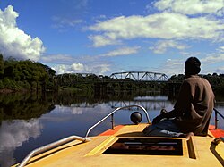
The Suriname River is 480 kilometres (300 mi) long and flows through the country of Suriname. Its sources are located in the Guiana Highlands on the border between the Wilhelmina Mountains and the Eilerts de Haan Mountains. The source of the Upper Suriname River is at the confluence of the Gran Rio and Pikin Rio near the village of Goddo. The river continues shortly after the reservoir along Brokopondo as the Lower Suriname River. Than it flows Berg en Dal, the migrant communities Klaaskreek and Nieuw-Lombé, Jodensavanne, Carolina, Ornamibo and Domburg, before reaching the capital Paramaribo on the left bank and Meerzorg on the right bank. At Nieuw-Amsterdam it is joined by the Commewijne and immediately thereafter at the sandspit Braamspunt it flows into the Atlantic Ocean.

Apoera, also Apura, is a town in western Suriname. The village has a population of 777 people as of 2020. It is the final destination of the Southern East-West Link. 24 kilometres (15 mi) north-west on the other side of the Courantyne River lies the Guyanese village of Orealla. The village is home to the Lokono tribe, but has been westernized. Due to the influx of people of Guyana, the languages used are English, and Sranan Tongo. Dutch is rarely spoken and the native language has all but disappeared. According to the oral tradition, Apoera was founded around 1920 by the Gordon family.

Meerzorg is a town and resort (municipality) in Suriname, located on the eastern bank of the Suriname River, directly opposite the capital Paramaribo. Its population at the 2012 census was 12,405. Since 2000 it has been connected to Paramaribo by the Jules Wijdenbosch Bridge, named after the former President Jules Wijdenbosch.
The (northern) East-West Link is a road in Suriname between Albina in the eastern part of the country to Nieuw Nickerie in the western part, via the capital city of Paramaribo. The southern East-West Link connects Paramaribo with Apoera via Bitagron. Construction of the road link started in the 1960s.

Javanese Surinamese are an ethnic group of Javanese Indonesians descent in Suriname. They have been present since the late 19th century, when their first members were selected as indentured laborers by the Dutch colonizers from the former Dutch East Indies.
Voetbal Vereniging Fearless, known as Fearless, was a Surinamese football club based in Moengo who played in the Hoofdklasse, the highest level of football in Suriname.

The geology of Suriname is predominantly formed by the Guyana Shield, which spans 90% of its land area. Coastal plains account for the remaining ten percent. Most rocks in Suriname date to the Precambrian. These crystalline basement rocks consists of granitoid and acid volcanic rocks with enclaves of predominantly low-grade metamorphic, geosynclinal rocks in the Marowijne area and of probably considerably older rocks in the Falawatra group of the Bakhuisgebirge and the Coronie area. There are also small, scattered bodies of gabbro and ultramafitite. These are about the same age as the granite and volcanics. It has been found that the construction of the basement was largely created during the final phase of the Trans-Amazonian Orogeny Cycle, about 1.9 billion years ago. This cycle has had a significant influence on the geology of Suriname, characterized by sedimentation, metamorphosis, corrugation and magmatism.

Braamspunt is a nature reserve, fishing village, and a former military outpost in the Johan & Margaretha resort of the Commewijne District of Suriname. Braamspunt is the most western point of the Commewijne District at the combined mouth of the Suriname and Commewijne River. The capital Paramaribo is located to the south of Braamspunt. The name is a corruption of Byam's Point which refers William Byam who was a quartermaster of Willoughby.

The Ferry terminal Leonsberg is a ferry jetty in the north of Paramaribo, Suriname. From here various private operators offer transport service the other side of the Suriname river and the Commewijne River.