Johanna Maria

Last updated
Johanna Maria
Vooraanzicht gevels - Burnside - 20418022 - RCE.jpg
Houses in Burnside
Coronie Resorts Suriname Neutral.png
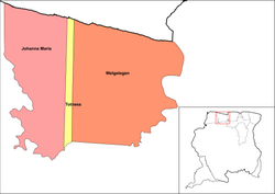
Map showing the resorts of Coronie District.
  Johanna Maria
CountryFlag of Suriname.svg  Suriname
District Coronie District
Area
  Total1,586 km2 (612 sq mi)
Population
 (2012) [1]
  Total648
  Density0.41/km2 (1.1/sq mi)
Time zone UTC-3 (AST)

Johanna Maria is a town and resort in Suriname, located in the Coronie District. Its population at the 2012 census was 648. [1] The town is named the cotton plantation Johanna Maria founded in 1801 [2] which was owned by Johanna Maria Christina van Onna from 1863 onwards. [3] The coast line subject to flooding and erosion caused by the degradation of the mangrove forests. Plans have been drawn up to construct a 12 kilometre long dike near the coast. [4]

Johanna Maria has a school, and clinic, but the area from Clyde to Burnside has no electricity, or telephone. [4] In 1970 the Krioro Masanga was built in Johanna Maria, a multi purpose information and recreation building with a theatre and a library. [5]

Related Research Articles

<span class="mw-page-title-main">Commewijne District</span> District of Suriname

Commewijne is a district of Suriname, located on the right bank of the Suriname River. Commewijne's capital city is Nieuw Amsterdam. Tamanredjo is another major town, while Meerzorg is the most populated.

<span class="mw-page-title-main">Brokopondo District</span> District of Suriname

Brokopondo is a district of Suriname. Its capital city is Brokopondo; other towns include Brownsweg and Kwakoegron.

<span class="mw-page-title-main">Coronie District</span> District of Suriname

Coronie is a district of Suriname, situated on the coast. Coronie's capital city is Totness. The district border the Atlantic Ocean to the north, the Surinamese district of Saramacca to the east, the Surinamese district of Sipaliwini to the south and the Surinamese district of Nickerie to the west. The district is served by the Totness Airstrip.

<span class="mw-page-title-main">Nickerie District</span> District of Suriname

Nickerie is a district of Suriname, on the north-west coast. Nickerie's capital city is Nieuw-Nickerie. Another town is Wageningen. The district borders the Atlantic Ocean to the north, the Surinamese district of Coronie to the east, the Surinamese district of Sipaliwini to the south and the region of East Berbice-Corentyne in Guyana to the west.

<span class="mw-page-title-main">Totness, Suriname</span> Resort and town in Coronie District, Suriname

Totness is a town in Suriname, located in the Coronie district, of which it is the capital. Totness is the oldest settlement in the district.

<span class="mw-page-title-main">Friendship, Suriname</span> Place in Coronie District, Suriname

Friendship is a town in the Totness resort in the Coronie district in Suriname. Friendship is a former cotton plantation founded in 1824. The village of Friendship is to the north of the East-West Link, and Totness is to the south of the road. A clinic is located in the town, and serves both Totness and Friendship. The school in Totness is shared with Friendship.

<span class="mw-page-title-main">Paradise, Suriname</span> Place in Nickerie District, Suriname

Paradise is a village in the Nickerie District of Suriname. It has a population of about 966 residents. The village is located about two kilometers from the town of Nieuw Nickerie.

<span class="mw-page-title-main">Meerzorg</span> Resort in Commewijne District, Suriname

Meerzorg is a town and resort (municipality) in Suriname, located on the eastern bank of the Suriname River, directly opposite the capital Paramaribo. Its population at the 2012 census was 12,405. Since 2000 it has been connected to Paramaribo by the Jules Wijdenbosch Bridge, named after the former President Jules Wijdenbosch.

<span class="mw-page-title-main">Klaaskreek</span> Resort in Brokopondo District, Suriname

Klaaskreek is a resort in Suriname, located in the Brokopondo District. Its population at the 2012 census was 2,124. Located northeast of Brokopondo, the main town is Reinsdorp. In 2007, a technical training centre in biological agriculture was established at Klaaskreek to teach locals about enhancing agriculture in the area.

<span class="mw-page-title-main">Marshallkreek</span> Resort in Brokopondo District, Suriname

Marshallkreek is a resort in Suriname, located in the Brokopondo District. Its population at the 2012 census was 1,171. The resort and town are named after Captain Marshall who first settled Suriname in 1630.

<span class="mw-page-title-main">Johan & Margaretha</span> Resort in Commewijne District, Suriname

Johan & Margaretha or sometimes just Margaretha is a resort in Suriname, located in the Commewijne District. Its population at the 2012 census was 756. It is located along a peninsula northeast of Paramaribo. It is named after the coffee plantation Johan & Margaretha which was founded in 1745 by Johan Knöffel. It is safe to assume that his wife was called Margaretha.

<span class="mw-page-title-main">Welgelegen, Coronie District</span> Resort in Coronie District, Suriname

Welgelegen is a resort in Suriname, located in the Coronie District. Its population at the 2012 census was 593. Welgelegen started as a cotton plantation in 1824. The church of Welgelegen was consecrated on 1 November 1883, but wasn't built at the spot. It was first erected on Cardross Park, and later moved to its current location. The church is no longer in service.

<span class="mw-page-title-main">Oostelijke Polders</span> Resort in Nickerie District, Suriname

Oostelijke Polders is a resort in Suriname located in the Nickerie District. Its population at the 2012 census was 7,153. Villages in the resort include Glasgow, Hamptoncourtpolder, and Paradise. Oostelijke Polders is an agricultural area with a focus on rice production. Oostelijke Polder has a clinic and a school.

<span class="mw-page-title-main">Zuid, Suriname</span> Resort in Para District, Suriname

Zuid is a resort in Suriname, located in the Para District. Its population at the 2012 census was 6,113. The main ethnic groups are indigenous, Creoles, and mixed race.

<span class="mw-page-title-main">Flora, Suriname</span> Resort in Paramaribo District, Suriname

Flora is a resort in Suriname, located in the Paramaribo District. Its population at the 2012 census was 19,538. Flora is both the name of the resort and the neighbourhood within the resort. Flora was founded as a wood plantation in 1809.

<span class="mw-page-title-main">Livorno, Suriname</span> Resort in Paramaribo District, Suriname

Livorno is a resort in Suriname, located in the Paramaribo District. Its population at the 2012 census was 8,209.

<span class="mw-page-title-main">De Nieuwe Grond</span> Resort in Wanica District, Suriname

De Nieuwe Grond is a resort in Suriname, located in the Wanica District. Its population at the 2012 census was 26,161. Its main ethnic groups are East Indian, and Creoles. The resort is named after a sugar plantation in 1770. The plantation was already abandoned in 1863, when slavery was abolished, because that year, it was up for public auction. The area used to consist of small scale agriculture with a focus on vegetables and rice, but due to its proximity to Paramaribo, it has become a suburban area with a young population. In 2019, a new bigger market opened in the town.

<span class="mw-page-title-main">Domburg, Suriname</span> Resort in Wanica District, Suriname

Domburg is a resort in the Wanica District of Suriname, located on the northern coast of South America. Its population at the 2012 census was 5,661.

<span class="mw-page-title-main">Houttuin</span> Resort in Wanica District, Suriname

Houttuin is a resort in Suriname, located in the Wanica District. Its population at the 2012 census was 15,656. The largest ethnic group are the Indo-Surinamese. The resort is named after the sugar plantation Houttuyn which was founded in 1737. The resort was mainly agricultural, and is planned to remain an agricultural centre. In the early 21st century, it has seen a steady population growth, and is becoming suburban with housing projects like Tout Lui Faut.

<span class="mw-page-title-main">Mary's Hope</span> Village in Coronie District, Suriname

Mary's Hope is a village in the Welgelegen resort of the Coronie District of Suriname. The village can be accessed from the East-West Link.

References

  1. 1 2 "2012 Census Resorts Suriname" (PDF). Spang Staging. Retrieved 11 May 2020.
  2. "Coronie Webportal - Johanna Maria" (in Dutch). Retrieved 25 May 2020.
  3. "Plantage Johanna Maria". Suriname Plantages. Retrieved 25 May 2020.
  4. 1 2 "Structuur Analyse" (PDF). Planning Office Suriname (in Dutch). Retrieved 25 May 2020.
  5. "Een geschiedenis van de Surinaamse literatuur. Deel 4". Digital Library for Dutch Literature (in Dutch). 2002. Retrieved 25 May 2020.

5°51′00″N56°28′11″W / 5.8501°N 56.4698°W / 5.8501; -56.4698