Coronie District

Last updated
Coronie
Coronie (2346317580).jpg
Translation of the sign:
Coronie: peaceful, free and friendly
Coronie in Suriname (+claims).svg
Map of Suriname showing Coronie district
Coordinates: 5°46′N56°17′W / 5.767°N 56.283°W / 5.767; -56.283
Country Suriname
Established1851
Capital Totness
Area
  Total3,902 km2 (1,507 sq mi)
Population
 (2012 census) [1]
  Total3,391
  Density0.87/km2 (2.3/sq mi)
Time zone UTC-3

Coronie is a district of Suriname, situated on the coast. Coronie's capital city is Totness. The district border the Atlantic Ocean to the north, the Surinamese district of Saramacca to the east, the Surinamese district of Sipaliwini to the south and the Surinamese district of Nickerie to the west. The district is served by the Totness Airstrip.

Contents

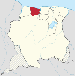
The district has a population of 3,391 and an area of 3,902 km2, and is the district with the smallest population. [1]

History

The first plantations were established from 1808 onwards by English and Scottish colonists. [2] Coronie became an independent district in 1851. [2] The oldest plantation in the district is Burnside. [3] Coronie was isolated and it was not until the 1940s, that a road was built linking Totness with Paramaribo, which is nowadays part of the East-West Link. [4]

In September 1965, four sounding rockets of Apache type with a maximum altitude of 205 km were launched. [5] The rockets were launched as part as an investigation into the workings of the jet stream. The project was carried out by University of Utrecht and Royal Netherlands Meteorological Institute. NASA provided the rockets. [6]

Totness has been designated as a regional centre in the beginning of the 21st century, and is planned to be upgrade with a medium-sized hotel and a proper city centre. [7] The area from Clyde to Burnside has no electricity, or telephone. [7]

Economy

Coronie, as with most of Suriname, relies mostly upon agriculture for both its income and its food supply. The coastal environment made it a suitable are for coconut and rice plantations. [2] In the late 20th century, rice became a major agricultural crop. The rice fields are suited in the south and along the East-West Link. [8]

The flat and muddy coast with shallow waters prevented the construction of major harbors and large ships had to anchor miles off shores and transfer their passengers and cargo to little boats. [3]

Resorts

Resorts of Coronie Coronie resorts.png
Resorts of Coronie

Coronie is divided into 3 resorts (ressorten):

Villages

Other villages in Coronie are:

Nature reserves

Coronie is home to three protected areas. The Peruvia Nature Reserve which was established in 1986 and covers 31,000 hectares, the Bigi Pan nature reserve which was established in 1987 and covers 67,000 hectares, and the Noord Coronie  [ nl ] protected area which was established in 1987 and covers 27,200 hectares. [7]

Related Research Articles

<span class="mw-page-title-main">Brokopondo District</span> District of Suriname

Brokopondo is a district of Suriname. Its capital city is Brokopondo; other towns include Brownsweg and Kwakoegron.

<span class="mw-page-title-main">Marowijne District</span> District of Suriname

Marowijne is a district of Suriname, located on the north-east coast. Marowijne's capital city is Albina, with other towns including Moengo and Wanhatti. The district borders the Atlantic Ocean to the north, French Guiana to the east, the Surinamese district of Sipaliwini to the south, and the Surinamese districts of Commewijne and Para to the west.

<span class="mw-page-title-main">Nickerie District</span> District of Suriname

Nickerie is a district of Suriname, on the north-west coast. Nickerie's capital city is Nieuw-Nickerie. Another town is Wageningen. The district borders the Atlantic Ocean to the north, the Surinamese district of Coronie to the east, the Surinamese district of Sipaliwini to the south and the region of East Berbice-Corentyne in Guyana to the west.

<span class="mw-page-title-main">Saramacca District</span> District of Suriname

Saramacca is a district of Suriname, in the north. Saramacca's capital city is Groningen, with other towns and cities including Batavia, Kampong Baroe, Uitkijk, Maho and Boskamp. Saramacca has a population of 17,480 and an area of 3,636 km2.

<span class="mw-page-title-main">Paramaccan people</span> Maroon ethnic group of northeast Suriname

The Paramaccan or Paramaka are a Maroon tribe living in the forested interior of Suriname, mainly in the Paramacca resort, and the western border area of French Guiana. The Paramaccan signed a peace treaty in 1872 granting the tribe autonomy.

<span class="mw-page-title-main">Nieuw Nickerie</span> Resort and City in Nickerie, Suriname

Nieuw Nickerie is the third largest city in Suriname with a population estimated at 12,818. It is the capital city of the Nickerie district, and the terminus of the East-West Link.

<span class="mw-page-title-main">Moengo</span> Resort in Marowijne District, Suriname

Moengo is a town in Suriname, located in the Marowijne district, between Paramaribo and the border town Albina on the Cottica River. Moengo is also a resort (municipality) in the district of Marowijne. Moengo was the capital of Marowijne District between 1932 and 1945. The current capital is Albina.

<span class="mw-page-title-main">Totness, Suriname</span> Resort and town in Coronie District, Suriname

Totness is a town in Suriname, located in the Coronie district, of which it is the capital. Totness is the oldest settlement in the district.

Jenny is a town on the East-West Link in Suriname, located in the Welgelegen resort of Coronie district. It lies on the mouth of the Coppename River opposite the town of Boskamp, to which it is linked by the Coppename bridge.

<span class="mw-page-title-main">Resorts of Suriname</span>

The ten districts of Suriname are divided into 63 resorts. Within the capital city of Paramaribo, a resort entails a neighbourhood; in other cases it is more akin to a municipality, consisting of a central place with a few settlements around it. The resorts in the Sipaliwini District are especially large, since the interior of Suriname is sparsely inhabited.

<span class="mw-page-title-main">Centrum, Brokopondo</span> Resort in Brokopondo District, Suriname

Centrum is a resort in Suriname, located in the Brokopondo District. Its population at the 2012 census was 4,482. Centrum can be reached by car via the Afobakaweg from Paranam to Afobaka, or by boat via the Suriname River.

<span class="mw-page-title-main">Klaaskreek</span> Resort in Brokopondo District, Suriname

Klaaskreek is a resort in Suriname, located in the Brokopondo District. Its population at the 2012 census was 2,124. Located northeast of Brokopondo, the main town is Reinsdorp. In 2007, a technical training centre in biological agriculture was established at Klaaskreek to teach locals about enhancing agriculture in the area.

<span class="mw-page-title-main">Johanna Maria</span> Resort in Coronie District, Suriname

Johanna Maria is a town and resort in Suriname, located in the Coronie District. Its population at the 2012 census was 648. The town is named the cotton plantation Johanna Maria founded in 1801 which was owned by Johanna Maria Christina van Onna from 1863 onwards. The coast line subject to flooding and erosion caused by the degradation of the mangrove forests. Plans have been drawn up to construct a 12 kilometre long dike near the coast.

<span class="mw-page-title-main">Welgelegen, Coronie District</span> Resort in Coronie District, Suriname

Welgelegen is a resort in Suriname, located in the Coronie District. Its population at the 2012 census was 593. Welgelegen started as a cotton plantation in 1824. The church of Welgelegen was consecrated on 1 November 1883, but wasn't built at the spot. It was first erected on Cardross Park, and later moved to its current location. The church is no longer in service.

<span class="mw-page-title-main">Patamacca</span> Resort in Marowijne District, Suriname

Patamacca is a resort in Suriname, located in the Marowijne District. Its population at the 2012 census was 427. Patamacca is a tribal area inhabited by Maroons

<span class="mw-page-title-main">Beekhuizen</span> Resort in Paramaribo District, Suriname

Beekhuizen is a former sugarcane plantation and currently a resort in Suriname, located in the Paramaribo District. Its population at the 2012 census was 17,185.

<span class="mw-page-title-main">Ndyuka people</span> Maroon ethnic group of Suriname and French Guiana

The Ndyuka people or Aukan people (Okanisi), are one of six Maroon peoples in the Republic of Suriname and one of the Maroon peoples in French Guiana. The Aukan or Ndyuka speak the Ndyuka language. They are subdivided into the Opu, who live upstream of the Tapanahony River in the Tapanahony resort of southeastern Suriname, and the Bilo, who live downstream of that river in Marowijne District

<span class="mw-page-title-main">Matawai people</span>

The Matawai are a tribe of Surinamese Maroons. The Matawai were originally part of the Saramaka, and signed a peace agreement with the Dutch colonists in 1762. The tribe split from the Saramaka, and in 1769, they were recognized as a separate tribe.

<span class="mw-page-title-main">Mary's Hope</span> Village in Coronie District, Suriname

Mary's Hope is a village in the Welgelegen resort of the Coronie District of Suriname. The village can be accessed from the East-West Link.

<span class="mw-page-title-main">Sara Creek (river)</span> River in Suriname

Sara Creek is a former tributary of the Suriname River located in the Para District of Suriname. After the completion of the Afobaka Dam in 1964, the Sara Creek flows into the Brokopondo Reservoir. In 1876, gold was discovered along the Sara Creek, and a railway line from Paramaribo to the river was completed in 1911.

References

  1. 1 2 "Resorts in Suriname Census 2012" (PDF). Retrieved 26 May 2020.
  2. 1 2 3 "Coronie Geschiedenis". Coronie.nl (in Dutch). Archived from the original on 19 January 2020. Retrieved 26 May 2020.
  3. 1 2 "Distrikt Coronie 1". Suriname.nu (in Dutch). Retrieved 26 May 2020.
  4. "Totness". Coronie.nl (in Dutch). Retrieved 8 May 2020.
  5. Astronautix.com
  6. "Raketlanceringen in Coronie 1965". Coronie.eu (in Dutch). Retrieved 26 May 2020.
  7. 1 2 3 "STRUCTUUR ANALYSE DISTRICTEN 2009-2013" (PDF). Planning Office Suriname (in Dutch). Retrieved 26 May 2020.
  8. "Distrikt Coronie 2". Suriname.nu (in Dutch). Retrieved 25 May 2020.

5°45′49″N56°16′40″W / 5.76361°N 56.27778°W / 5.76361; -56.27778