Wayamboweg | |
|---|---|
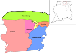 Map showing the resorts of Saramacca District. Wayamboweg | |
| Country | |
| District | Saramacca District |
| Area | |
• Total | 872 km2 (337 sq mi) |
| Population (2012) [1] | |
• Total | 1,560 |
| • Density | 1.8/km2 (4.6/sq mi) |
| Time zone | UTC-3 (AST) |
Wayamboweg is a resort in Suriname, located in the Saramacca District. Its population at the 2012 census was 1,560. The largest ethnic group is East Indian. [1] The resort is mainly agricultural. [2] A rice project has started in late 2017. [3]
In the early 21st century, a high school has been opened. The resort is located near the ocean, and tourism facilities are being developed in the resort. [2] Staatsolie is drilling for oil in the Wayambozwamp. [4]
The village of Smithfield is located in the area.
