Paramaribo is the capital and largest city of Suriname, located on the banks of the Suriname River in the Paramaribo District. Paramaribo has a population of roughly 241,000 people, almost half of Suriname's population. The historic inner city of Paramaribo has been a UNESCO World Heritage Site since 2002.
Commewijne is a district of Suriname, located on the right bank of the Suriname River. Commewijne's capital city is Nieuw Amsterdam. Tamanredjo is another major town, while Meerzorg is the most populated.

Wanica is a district of Suriname located in the north of the country. Wanica's capital city is Lelydorp, the second-largest city in Suriname. Wanica has a population of 118,222 and an area of 443 km2. Following neighboring Paramaribo, Wanica is the second most populated and urbanized district of Suriname. Two-thirds of the country's population live in these two districts.

Lelydorp is the capital city of Wanica District, located in Suriname’s north. With a population of 18,663 (2012), it is the second largest city in Suriname, after Paramaribo.

Nieuw Amsterdam is the capital of the Commewijne District in Suriname. It is a small coastal town situated at the confluence of the Suriname River and Commewijne River, just across from Paramaribo, the country's capital. Its population at the 2012 census was 5,650, with around 1,200 people living in the main town, most of whom are of Javanese and East Indian origin. It is the location of the historical Fort Nieuw-Amsterdam, today an open-air museum. The town of Mariënburg with former sugarcane factory is located 3 km from Nieuw Amsterdam and part of the resort.

The Suriname River is 480 kilometres (300 mi) long and flows through the country of Suriname. Its sources are located in the Guiana Highlands on the border between the Wilhelmina Mountains and the Eilerts de Haan Mountains. The source of the Upper Suriname River is at the confluence of the Gran Rio and Pikin Rio near the village of Goddo. The river continues shortly after the reservoir along Brokopondo as the Lower Suriname River. Than it flows Berg en Dal, the migrant communities Klaaskreek and Nieuw-Lombé, Jodensavanne, Carolina, Ornamibo and Domburg, before reaching the capital Paramaribo on the left bank and Meerzorg on the right bank. At Nieuw-Amsterdam it is joined by the Commewijne and immediately thereafter at the sandspit Braamspunt it flows into the Atlantic Ocean.

Pokigron is a town in Suriname located on the Upper Suriname River near the Brokopondo Reservoir. It is located in the Boven Suriname municipality (resort) in the Sipaliwini District. It has a population of approximately 400 people in 2018. Pokigron is located at the end of a paved road via Brownsweg to the Avobakaweg. Pokigron is often referred to as Atjoni which is the nearby quay, and literally the end of the road. Villages to the South of Pokigron have to be accessed by boat. The village is home to Maroons of the Saramaka tribe.
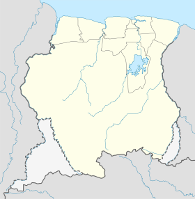
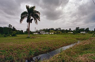
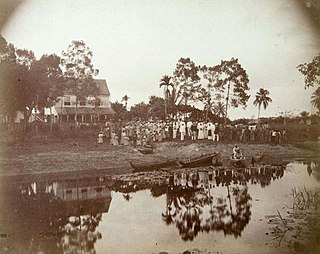
Laarwijk is a settlement and a former sugar plantation in the Commewijne District in Suriname. Laarwijk is situated along the Suriname River and can only be reached by boat.

Meerzorg is a town and resort (municipality) in Suriname, located on the eastern bank of the Suriname River, directly opposite the capital Paramaribo. Its population at the 2012 census was 12,405. Since 2000 it has been connected to Paramaribo by the Jules Wijdenbosch Bridge, named after the former President Jules Wijdenbosch.

Klaaskreek is a resort in Suriname, located in the Brokopondo District. Its population at the 2012 census was 2,124. Located northeast of Brokopondo, the main town is Reinsdorp. In 2007, a technical training centre in biological agriculture was established at Klaaskreek to teach locals about enhancing agriculture in the area.

Johan & Margaretha or sometimes just Margaretha is a resort in Suriname, located in the Commewijne District. Its population at the 2012 census was 756. It is located along a peninsula northeast of Paramaribo. It is named after the coffee plantation Johan & Margaretha which was founded in 1745 by Johan Knöffel. It is safe to assume that his wife was called Margaretha.

Zuid is a resort in Suriname, located in the Para District. Its population at the 2012 census was 6,113. The main ethnic groups are indigenous, Creoles, and mixed race.

Flora is a resort in Suriname, located in the Paramaribo District. Its population at the 2012 census was 19,538. Flora is both the name of the resort and the neighbourhood within the resort. Flora was founded as a wood plantation in 1809.
Livorno is a resort in Suriname, located in the Paramaribo District. Its population at the 2012 census was 8,209.

De Nieuwe Grond is a resort in Suriname, located in the Wanica District. Its population at the 2012 census was 26,161. Its main ethnic groups are East Indian, and Creoles. The resort is named after a sugar plantation in 1770. The plantation was already abandoned in 1863, when slavery was abolished, because that year, it was up for public auction. The area used to consist of small scale agriculture with a focus on vegetables and rice, but due to its proximity to Paramaribo, it has become a suburban area with a young population. In 2019, a new bigger market opened in the town.

Houttuin is a resort in Suriname, located in the Wanica District. Its population at the 2012 census was 15,656. The largest ethnic group are the Indo-Surinamese. The resort is named after the sugar plantation Houttuyn which was founded in 1737. The resort was mainly agricultural, and is planned to remain an agricultural centre. In the early 21st century, it has seen a steady population growth, and is becoming suburban with housing projects like Tout Lui Faut.
Koewarasan is a resort in Suriname, located in the Wanica District. Its population at the 2012 census was 27,713. It is located to the west of Paramaribo, and is mainly a suburban area. The municipality was founded in 1939, and was originally intended for the Javanese settlers from Java, however due to World War II, only a single group arrived. The majority of the population are East Indian. Prior to 1939, Koewarasan was an agricultural area used for the cultivation of rice.

Kwatta is a resort in Suriname, located in the Wanica District. Its population at the 2012 census was 14,151.
Saramacca Polder is a resort in Suriname, located in the Wanica District. Its population at the 2012 census was 10,217. And the majority of the population is of East Indian descent. The Saramacca Polder was created between 1894 and 1904. The main function was agriculture. The Commissaris Weytinghweg was built in 1906, and connects the polder with Paramaribo. Initially the area was mainly used for rice cultivation, but has become home to companies and suburban housing.

Chandrikapersad "Chan" Santokhi is a Surinamese politician and former police officer who is the 9th president of Suriname, since 2020. After winning the 2020 elections, Santokhi was the sole nominee for president of Suriname. On 13 July, Santokhi was elected president by acclamation in an uncontested election. He was inaugurated on 16 July.