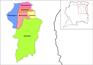
Brokopondo is a district of Suriname. Its capital city is Brokopondo; other towns include Brownsweg and Kwakoegron.

Para is a district of northern Suriname. Para's capital city is Onverwacht, with other towns including Paranam, and Zanderij. Para has a population of 24,700 and an area of 5,393 km2. The district is the mining and forestry centre of Suriname, with many large bauxite mining operations operating. The district is a mixture of forest and savannas.

Brokopondo is the capital town of the Brokopondo District, Suriname. It is located on the west shore of the Suriname river, just north of the Afobaka dam, 105 kilometers south-east of Suriname capital city of Paramaribo. Brokopondo can be reached via the Afobakaweg from Paranam to Afobaka.
Lebidoti is a village in Suriname with a population of about 1,000 and two nearby villages of Bakoe and Pitean. The people are of Maroon descent, specifically the Aukan tribe, and moved to this specific location when the building of the Afobaka dam created the Brokopondo Reservoir.

Kajana is a village in Sipaliwini District, Suriname. It lies on the Gaan-lio, which together with the Pikin Lio forms the Suriname River. The population call themselves Kadosi-nengre after Cardoso who was the owner of the plantation they ran away from. The village is home to Maroons of the Saramaka tribe.

Brownsweg is a town and resort in Suriname in the Brokopondo District. Its population at the 2012 census was 4,793.

Pokigron is a town in Suriname located on Brokopondo Reservoir. It is located in the Boven Suriname municipality (resort) in the Sipaliwini District. It has a population of approximately 400 people in 2018. Pokigron is located at the end of a paved road via Brownsweg to the Afobakaweg. Pokigron is often referred to as Atjoni which is the nearby quay, and literally the end of the road. Villages to the South of Pokigron have to be accessed by boat. The village is home to Maroons of the Saramaka tribe.

Meerzorg is a town and resort (municipality) in Suriname, located on the eastern bank of the Suriname River, directly opposite the capital Paramaribo. Its population at the 2012 census was 12,405. Since 2000 it has been connected to Paramaribo by the Jules Wijdenbosch Bridge, named after the former President Jules Wijdenbosch.

Centrum is a resort in Suriname, located in the Brokopondo District. Its population at the 2012 census was 4,482. Centrum can be reached by car via the Afobakaweg from Paranam to Afobaka, or by boat via the Suriname River.

Klaaskreek is a resort in Suriname, located in the Brokopondo District. Its population at the 2012 census was 2,124. Located northeast of Brokopondo, the main town is Reinsdorp. In 2007, a technical training centre in biological agriculture was established at Klaaskreek to teach locals about enhancing agriculture in the area.

Sarakreek is a resort in the gold mining region of Brokopondo District in Suriname. Its population at the 2012 census was 3,076. It is served by the Sarakreek Airstrip. The resort is named after the eponymous creek.

Alkmaar is a resort in Suriname, located in the Commewijne District. Its population at the 2012 census was 5,561.

Johan & Margaretha or sometimes just Margaretha is a resort in Suriname, located in the Commewijne District. Its population at the 2012 census was 756. It is located along a peninsula northeast of Paramaribo. It is named after the coffee plantation Johan & Margaretha which was founded in 1745 by Johan Knöffel. It is safe to assume that his wife was called Margaretha.
Livorno is a resort in Suriname, located in the Paramaribo District. Its population at the 2012 census was 8,209.

Afobaka is a village in the Brokopondo District of Suriname. Between 1960 and 1964, the 1913 meter-long Afobaka Dam was built on the Suriname River, creating the Brokopondo Reservoir. The Afobaka Airstrip is nearby.

Diitabiki is a Ndyuka village in the Sipaliwini District of Suriname. Diitabiki is the residence of the gaanman of the Ndyuka people, since 1950, and the location of the oracle.

Langatabiki is a Paramacca village in the Sipaliwini District of Suriname. Langatabiki is the residence of the granman of the Paramaccan people. Langatabiki is located in the Pamacca resort which was created on 11 September 2019 out of Tapanahony.
Medische Zending Primary Health Care Suriname, commonly known as Medische Zending or MZ is a Surinamese charitable organization offering primary healthcare to remote villages in the interior of Suriname.

Berg en Dal is a village in the resort of Klaaskreek in the Brokopondo District of Suriname. The village is located on the Suriname River.

Paramacca is a resort in Suriname, located in the Sipaliwini District. The population is estimated between 1,500 and 2,000 people. In 1983, the Sipaliwini District was created, and the eastern part became the resort of Tapanahony. The Paramacca resort is the northern part of Tapanahony, and mainly inhabited by the Paramaccan people, the border of the resorts is the island of Bofoo Tabiki in the Marowijne River.