The Republic of Suriname has a number of forms of transport. Transportation emissions are an increasing part of Suriname's contributions to climate change, as part of the Nationally Determined Contributions for the Paris Agreement, Suriname has committed to emissions controls for vehicles and increased public transit investment.

Paramaribo is the capital and largest city of Suriname, located on the banks of the Suriname River in the Paramaribo District. Paramaribo has a population of roughly 241,000 people, almost half of Suriname's population. The historic inner city of Paramaribo has been a UNESCO World Heritage Site since 2002.
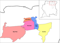
Commewijne is a district of Suriname, located on the right bank of the Suriname River. Commewijne's capital city is Nieuw Amsterdam. Tamanredjo is another major town, while Meerzorg is the most populated.

Para is a district of northern Suriname. Para's capital city is Onverwacht, with other towns including Paranam, and Zanderij. Para has a population of 24,700 and an area of 5,393 km2. The district is the mining and forestry centre of Suriname, with many large bauxite mining operations operating. The district is a mixture of forest and savannas.

Lelydorp is the capital city of Wanica District, located in Suriname’s north. With a population of 18,663 (2012), it is the second largest city in Suriname, after Paramaribo.

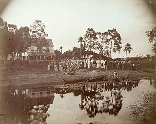
Nieuw Amsterdam is the capital of the Commewijne District in Suriname. It is a small coastal town situated at the confluence of the Suriname River and Commewijne River, just across from Paramaribo, the country's capital. Its population at the 2012 census was 5,650, with around 1,200 people living in the main town, most of whom are of Javanese and East Indian origin. It is the location of the historical Fort Nieuw-Amsterdam, today an open-air museum. The town of Mariënburg with former sugarcane factory is located 3 km from Nieuw Amsterdam and part of the resort.

Tapanahoni is a resort in Suriname, located in the Sipaliwini District. Its population at the 2012 census was 13,808. Tapanahoni is a part of Sipaliwini which has no capital, but is directly governed from Paramaribo. Tapanahony is an enormous resort which encompasses a quarter of the country of Suriname. The most important town is Diitabiki which is the residence of the granman of the Ndyuka people since 1950, and the location of the oracle.

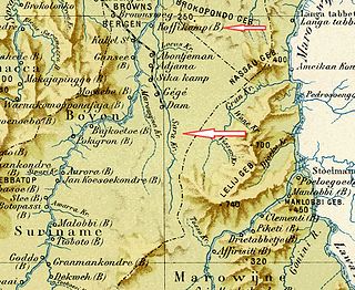
Kwakoegron is a town and resort in Suriname. It is located inland, due south of Paramaribo. According to the 2012 census it has a population of 263, and is mainly inhabited by Maroons, of the Matawai people. The resort and town are named after Kwakoe, the native word for Wednesday, and grond, the Dutch word for ground. The captain of the resort resides in the village Commisariskondre.

Meerzorg is a town and resort (municipality) in Suriname, located on the eastern bank of the Suriname River, directly opposite the capital Paramaribo. Its population at the 2012 census was 12,405. Since 2000 it has been connected to Paramaribo by the Jules Wijdenbosch Bridge, named after the former President Jules Wijdenbosch.

Blauwgrond is a resort in Suriname, located in the Paramaribo District. Its population at the 2012 census was 31,483. Blauwgrond started as a Javanese village to the north of Paramaribo. During the 1960s and 1970s, large scale building projects turned the village into a neighbourhood of Paramaribo, and is mainly known as the Javanese culinary centre with many warungs and restaurants. The resort was called Blauwgrond, because the earth had a bluish colour.

Flora is a resort in Suriname, located in the Paramaribo District. Its population at the 2012 census was 19,538. Flora is both the name of the resort and the neighbourhood within the resort. Flora was founded as a wood plantation in 1809.
Latour is a resort in Suriname, located in the Paramaribo District. Its population at the 2012 census was 29,526. Latour is a low income neighbourhood with large unemployment. Latour is the most populous resort of Paramaribo.
Livorno is a resort in Suriname, located in the Paramaribo District. Its population at the 2012 census was 8,209.

De Nieuwe Grond is a resort in Suriname, located in the Wanica District. Its population at the 2012 census was 26,161. Its main ethnic groups are East Indian, and Creoles. The resort is named after a sugar plantation in 1770. The plantation was already abandoned in 1863, when slavery was abolished, because that year, it was up for public auction. The area used to consist of small scale agriculture with a focus on vegetables and rice, but due to its proximity to Paramaribo, it has become a suburban area with a young population. In 2019, a new bigger market opened in the town.

Kwatta is a resort in Suriname, located in the Wanica District. Its population at the 2012 census was 14,151.

Braamspunt is a nature reserve, fishing village, and a former military outpost in the Johan & Margaretha resort of the Commewijne District of Suriname. Braamspunt is the most western point of the Commewijne District at the combined mouth of the Suriname and Commewijne River. The capital Paramaribo is located to the south of Braamspunt. The name is a corruption of Byam's Point which refers William Byam who was a quartermaster of Willoughby.
Pikin Saron is an indigenous village of Kalina Amerindians in the resort of Zuid in the Para District in Suriname. The village can be accessed from the Southern East-West Link, and is located on the Saramacca River.
Sara Creek is a former tributary of the Suriname River located in the Para District of Suriname. After the completion of the Afobaka Dam in 1964, the Sara Creek flows into the Brokopondo Reservoir. In 1876, gold was discovered along the Sara Creek, and a railway line from Paramaribo to the river was completed in 1911.

Berlijn is a village and former wood plantation in the resort of Zuid in the Para District in Suriname. It is located on the Para Creek, and about 4 kilometres (2.5 mi) from the Johan Adolf Pengel International Airport.

Fort Sommelsdijk was a fort in Suriname built in 1686 at the confluence of the Commewijne and Cottica rivers. Later it was used as a mission post and hospital. In 1870, it lost its function and was only used a military outpost. In the 21st century, the fort was taken over by nature.