De Nieuwe Grond

Last updated
De Nieuwe Grond
Tropenmuseum Royal Tropical Institute Objectnumber 10030617 Laan met Hevea rubberbomen op plantag.jpg
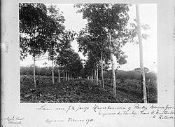
Rubber trees on De Nieuwe Grond (1911)
Wanica Ressorts Suriname Neutral.png
Map showing the resorts of Wanica District.
  De Nieuwe Grond
CountryFlag of Suriname.svg Suriname
District Wanica District
Area
  Total
38 km2 (15 sq mi)
Population
 (2012) [1]
  Total
26,161
  Density690/km2 (1,800/sq mi)
Time zone UTC-3 (AST)

De Nieuwe Grond is a resort in Suriname, located in the Wanica District. Its population at the 2012 census was 26,161. Its main ethnic groups are East Indian, and Creoles. [1] The resort is named after a sugar [2] plantation in 1770. [3] The plantation was already abandoned in 1863, when slavery was abolished, because that year, it was up for public auction. [4] The area used to consist of small scale agriculture with a focus on vegetables and rice, [5] but due to its proximity to Paramaribo, it has become a suburban area with a young population. [6] In 2019, a new bigger market opened in the town. [7]

References

  1. 1 2 "Census 2012" (PDF). Stang Makandra. Archived from the original (PDF) on 4 May 2019. Retrieved 23 May 2020.
  2. "Surinaamsche Staatkundige Almanach voor den Jaare 1793". Digital Library for Dutch Literature (in Dutch). 1793. Retrieved 23 May 2020.
  3. "Plantage De Nieuwe Ground". Suriname Plantages (in Dutch). Retrieved 23 May 2020.
  4. "Diverse News and Advertisements". De West-Indiër via Delpher . 15 July 1863. Retrieved 23 May 2020.
  5. "Geschiedenis van Wanica deel 3" (in Dutch). Archived from the original on 23 April 2021. Retrieved 23 May 2020.
  6. "Resultaten 8e Volks- en Woningtelling in Suriname" (PDF). UN Stats (in Dutch). Retrieved 23 May 2020.
  7. "Feestelijke heropening De Nieuwe Grond markt". GFC Nieuws (in Dutch). Retrieved 23 May 2020.

5°45′2″N55°12′5″W / 5.75056°N 55.20139°W / 5.75056; -55.20139