Suriname, officially the Republic of Suriname, is a country in northern South America, sometimes considered part of the Caribbean and the West Indies. Suriname is a developing country with a medium level of human development; its economy is heavily dependent on its abundant natural resources, namely bauxite, gold, petroleum, and agricultural products. Suriname is a member of the Caribbean Community (CARICOM), the United Nations, and the Organisation of Islamic Cooperation.

The Guiana Shield is one of the three cratons of the South American Plate. It is a 1.7 billion-year-old Precambrian geological formation in northeast South America that forms a portion of the northern coast. The higher elevations on the shield are called the Guiana Highlands, which is where the table-like mountains called tepuis are found. The Guiana Highlands are also the source of some of the world's most well-known waterfalls such as Angel Falls, Kaieteur Falls and Cuquenan Falls.
The Global 200 is the list of ecoregions identified by the World Wide Fund for Nature (WWF), the global conservation organization, as priorities for conservation. According to WWF, an ecoregion is defined as a "relatively large unit of land or water containing a characteristic set of natural communities that share a large majority of their species dynamics, and environmental conditions". For example, based on their levels of endemism, Madagascar gets multiple listings, ancient Lake Baikal gets one, and the North American Great Lakes get none.

Tropical and subtropical moist broadleaf forests (TSMF), also known as tropical moist forest, is a subtropical and tropical forest habitat type defined by the World Wide Fund for Nature.

Sipaliwini is the largest district of Suriname, located in the south. Sipaliwini is the only district that does not have a regional capital, as it is directly administered by the national government in Paramaribo. Sipaliwini District includes disputed areas, with the southwestern region controlled and administered by Guyana, whereas the southeastern region is controlled by French Guiana.

The Carbet Mountains are a massif of volcanic origin on the Caribbean island of Martinique.

The Iwokrama Forest is a 3,716 square kilometres (1,435 sq mi) nature reserve of central Guyana located in the heart of the Guiana Shield, one of the four last pristine tropical forests in the world. It represents an important transition zone in rainfall, landforms, human histories and biological communities.
The Wilhelminagebergte is a mountain range in the district of Sipaliwini in central Suriname. It extends about 113 km (70 mi) from west to east. It is named after Queen Wilhelmina. The Wilhelminagebergte is part of the Tumucumaque Uplands of the Guiana Shield. It belongs to the very ancient (Precambrian) Guiana Highlands. Most of it is in the Central Suriname Nature Reserve.

The Guianan cock-of-the-rock is a species of cotinga, a passerine bird from South America. It is about 30 cm (12 in) in length and weighs about 200 to 220 g. It is found in tropical rainforests, near its preferred habitat of rocky outcrops. The female's plumage is brownish/dark smokey grey in colour, and generally less noticeable than the males because of their nesting work in rocky areas. The male's feathers are a bright orange. Both have a heavy body, broad-based bill and wear a remarkable half-moon crest on the head. It is one of two species of the genus Rupicola, the other being the Andean cock-of-the-rock. The Guianan cock-of-the-rock lives across the forested region of northeastern South America. Its diet consists mostly of fruit, but they sometimes feast on small snakes and lizards.
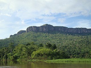
The Eilerts de Haan Mountains are a mountain range in Sipaliwini District, Suriname. It is a southern part of Wilhelmina Mountains and is maximum 986 m high. The mountain range is part of the Central Suriname Nature Reserve.
The Mamirauá Sustainable Development Reserve in the Brazilian state of Amazonas, near the city of Tefé, is a 4,300-square-mile (11,000 km2) reserve near the village of Boca do Mamirauá. It includes mostly Amazonian flooded forest and wetlands. The ribeirinhos are native to the area.

Raleigh Vallen Airstrip is an airstrip serving the Central Suriname Nature Reserve, Suriname. The runway is on Fungu Tabiki, an island in the Coppename River.

Chiribiquete National Natural Park is the largest national park in Colombia and the largest tropical rainforest national park in the world. It was established on 21 September 1989 and has been expanded twice, first in August 2013 and then in July 2018. The park occupies about 43,000 km2 (17,000 sq mi) and includes the Serranía de Chiribiquete mountains and the surrounding lowlands, which are covered by tropical moist forests, savannas and rivers.

Brownsberg Nature Park is a nature park located in Suriname. The site measures 12,000 ha and is located in the district of Brokopondo around 130 km south from the capital city Paramaribo. The 500-meter high Brownsberg is the central point of the park. The site is located near the Brokopondo Reservoir. The park is managed by STINASU. Often the people of Suriname use the word Brownsberg as simple variant of Brownsberg Nature Park. Local people also write it as Bruijnsberg, pronounced as Braynsberg.

The Guianan savanna (NT0707) is an ecoregion in the south of Venezuela, Guyana and Suriname and the north of Brazil. It is in the Amazon biome. The savanna covers an area of rolling upland plains on the Guiana Shield between the Amazon and Orinoco basins. It includes forested areas, but these are shrinking steadily due to the effect of frequent fires, either accidental or deliberate. The ecoregion includes the Gran Sabana region of Venezuela.
The Guayanan Highlands moist forests (NT0124) is an ecoregion in the south of Venezuela, the north of Brazil, and also within Guyana, Suriname, and French Guiana. It is in the Amazon biome. It encompasses an upland region with diverse fauna and flora, which contains dramatic tepuis, or sandstone table mountains. The region has been inaccessible in the past and is generally fairly intact, apart from the north and northeast where large scale agriculture, ranching and mining operations are steadily encroaching on the ecosystem. New roads are opening the interior to logging, and planned dams will have a drastic impact on the riparian zones.

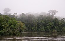
The Guianan moist forests (NT0125) is an ecoregion in the east of Venezuela, north of Brazil and the Guyanas. It is in the Amazon biome. The climate is hot and humid, with two rainy seasons each year. As of 1996 the tropical rainforest habitat was relatively intact, although there were mounting threats from illegal logging and gold mining.

The Amazon–Orinoco–Southern Caribbean mangroves (NT1401) is an ecoregion along the coasts of Colombia, Venezuela, Guyana, Suriname, French Guiana and Brazil.

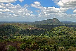
Voltzberg is a mountain in Suriname at 240 metres (787 ft). It is part of the Emma Range and is located in the Sipaliwini District. It is named after the German geologist Friedrich Voltz. Voltzberg used to form a nature reserve together with the close by Raleigh Falls. In 1998, it became part of the Central Suriname Nature Reserve.