
Suriname, officially the Republic of Suriname, is a country in northern South America, sometimes considered part of the Caribbean and the West Indies. It is a developing country with a medium level of human development; its economy is heavily dependent on its abundant natural resources, namely bauxite, gold, petroleum, and agricultural products. Suriname is a member of the Caribbean Community (CARICOM), the United Nations, and the Organisation of Islamic Cooperation.

Weststellingwerf is a municipality in the province of Friesland in the northern Netherlands. It is one of the municipalities of Friesland where the spoken language is not West Frisian; instead, Stellingwerfs, a dialect of Dutch Low Saxon, is spoken here.

Sipaliwini is the largest district of Suriname, located in the south. Sipaliwini is the only district that does not have a regional capital, as it is directly administered by the national government in Paramaribo. Sipaliwini District includes disputed areas, with the southwestern region controlled and administered by Guyana, whereas the southeastern region is controlled by French Guiana.
Surinam Airways, also known by its initials SLM, is the flag carrier of Suriname, based in Paramaribo. It operates regional and long-haul scheduled passenger services. Its hub is at Johan Adolf Pengel International Airport (Zanderij). Surinam Airways is wholly owned by the Government of Suriname.

The Central Suriname Nature Reserve is a conservation unit in Suriname. It preserves an area of tropical rainforest. The reserve is in pristine condition.
The Tapanahony River is a major river in the south eastern part of Suriname, South America. The river originates in the Southern part of the Eilerts de Haan Mountains, near the border with Brazil. It joins the Marowijne River at a place called Stoelmanseiland. Upstream, there are many villages inhabited by Indian Tiriyó people, while further downstream villages are inhabited by the Amerindian Wayana and Maroon Ndyuka people.

The Suriname River is 480 kilometres (300 mi) long and flows through the country of Suriname. Its sources are located in the Guiana Highlands on the border between the Wilhelmina Mountains and the Eilerts de Haan Mountains. The source of the Upper Suriname River is at the confluence of the Gran Rio and Pikin Rio near the village of Goddo. The river continues shortly after the reservoir along Brokopondo as the Lower Suriname River. Than it flows Berg en Dal, the migrant communities Klaaskreek and Nieuw-Lombé, Jodensavanne, Carolina, Ornamibo and Domburg, before reaching the capital Paramaribo on the left bank and Meerzorg on the right bank. At Nieuw-Amsterdam it is joined by the Commewijne and immediately thereafter at the sandspit Braamspunt it flows into the Atlantic Ocean.
The Wilhelminagebergte is a mountain range in the district of Sipaliwini in central Suriname. It extends about 113 km (70 mi) from west to east. It is named after Queen Wilhelmina. The Wilhelminagebergte is part of the Tumucumaque Uplands of the Guiana Shield. It belongs to the very ancient (Precambrian) Guiana Highlands. Most of it is in the Central Suriname Nature Reserve.

Florian Vijent, was a Dutch football goalkeeper. During his career he played for Telstar. He died at the age of 27, when on 7 June 1989, he was killed in the Surinam Airways Flight PY764 air crash in Paramaribo. He is not related to Ed Vijent.
Radjin de Haan is a retired Dutch footballer and currently is a football manager. During his career he served Telstar, FC Eindhoven and FC Den Bosch. He was one of the footballers that survived the Surinam Airways Flight PY764 air crash in Paramaribo on 7 June 1989. He was the only player to return on the pitch after the disaster.

Noordwolde is a village in Weststellingwerf in the province of Friesland, the Netherlands. It had a population of around 3,600 as of 2017. Noordwolde-Zuid, the settlement to the south of Noordwolde is considered a separate village.
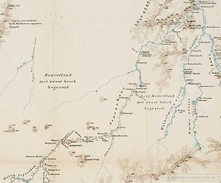
Gran Rio is a river of Suriname. The Gran Rio joins with the Pikin Rio to form the Upper Suriname River. The river runs from the northern hills of the Eilerts de Haan Mountains. It has a stony bottom, forms many tiny islands and has many rapids. The river was first explored in 1908 by Eilerts de Haan to find the source of the Suriname River.
Lucie River is a river of Suriname. It feeds into the Atlantic Ocean as well as the Courantyne River. The river was discovered and named by Eilerts de Haan in 1908. Eilerts de Haan is buried near the river.

Boven Suriname is a resort in Suriname, located in the Sipaliwini District. Its population at the 2012 census was 17,954. Almost its entire population consists of Maroons
The Bakhuis Mountains are a mountain range in central Suriname, spanning 110 kilometres. The mountain range form of the northern part of the Wilhelmina Mountains, and the mountains and its village were named after the Dutch explorer and Royal Dutch East Indies Army officer Louis August Bakhuis. The range lies in the Sipaliwini Savanna District of Suriname. The Bakhuys Airstrip is near the village.
Johannes Gijsbert Willem Jacobus (Johan) Eilerts de Haan was a Dutch explorer and soldier. Eilerts de Haan Nature Park in Suriname is named for him.
De Haan or de Haan is a Dutch family name meaning "The Rooster". In 2007 20,707 people had this name in the Netherlands alone, making it the 29th most common name in that country. Variant spellings are De Haen, DeHaan, and Den Haan. People with this name include:
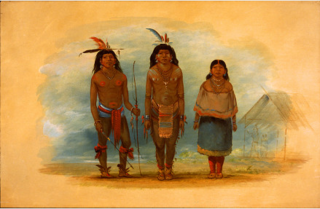
The Taruma are an indigenous people found in the northern Brazil, southern Guyana, and southern Suriname. They used to speak Taruma which is considered critically endangered. The Taruma in Suriname have merged with the Tiriyó, in Brazil they merged with the Wai-wai. The Wapishana village of Maruranau in Guyana still recognises the tribe.

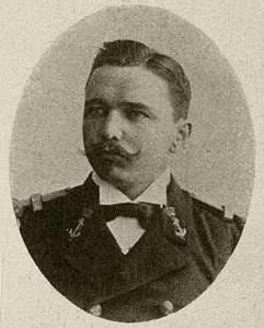
Conrad Carel Käyser was a Dutch naval officer, explorer and mountaineer. He led two expeditions in Suriname, among which the expedition at the end of the 1930s to mark the Brazilian–Surinamese border.
