
Brokopondo is a district of Suriname. Its capital city is Brokopondo; other towns include Brownsweg and Kwakoegron.

Coronie is a district of Suriname, situated on the coast. Coronie's capital city is Totness. The district border the Atlantic Ocean to the north, the Surinamese district of Saramacca to the east, the Surinamese district of Sipaliwini to the south and the Surinamese district of Nickerie to the west. The district is served by the Totness Airstrip.

Saramacca is a district of Suriname, in the north. Saramacca's capital city is Groningen, with other towns and cities including Batavia, Kampong Baroe, Uitkijk, Maho and Boskamp. Saramacca has a population of 17,480 and an area of 3,636 km2.

Kwakoegron is a town and resort in Suriname. It is located inland, due south of Paramaribo. According to the 2012 census it has a population of 263, and is mainly inhabited by Maroons, of the Matawai people. The resort and town are named after Kwakoe, the native word for Wednesday, and grond, the Dutch word for ground. The captain of the resort resides in the village Commisariskondre.

Brownsweg is a town and resort in Suriname in the Brokopondo District. Its population at the 2012 census was 4,793.

Oostelijke Polders is a resort in Suriname located in the Nickerie District. Its population at the 2012 census was 7,153. Villages in the resort include Glasgow, Hamptoncourtpolder, and Paradise. Oostelijke Polders is an agricultural area with a focus on rice production. Oostelijke Polder has a clinic and a school.
Galibi is a resort in Suriname, located in the Marowijne District. Its population at the 2012 census was 741. Galibi is a tribal area inhabited by an indigenous population of Kalina Amerindians.
The biodiversity of Suriname is high, mostly because of the variety of habitats and warm temperatures. The average annual temperature in the coastal area is between 26° and 28°C. Suriname can be divided into four major ecological zones, namely from north to south;
- The young coastal plain
- The old coastal plain
- The Savannah or Zanderij belt
- The interior residual uplands

The Sipaliwini Savanna is a protected area and nature reserve in Suriname. The reserve is located to the south of the Sipaliwini River in the far south of the country. The reserve measures 100,000 hectares, and has been a protected area since 1972. The majority of the reserve consists of a savannah which in turn is a continuation of the Brazilian Tumucumaque Mountains National Park. The reserve is in pristine condition with almost no human habitation.
Boslanti is a village of Matawai Maroons in the resort of Boven Saramacca in the Sipaliwini District of Suriname. Boslanti is located on the Saramacca River.
Alfonsdorp is a village of indigenous Lokono people in the Albina resort of the Marowijne District of Suriname. The village is located on the East-West Link. The Wanekreek Nature Reserve is located near the village.
The Boven Coesewijne Nature Reserve is a protected area and nature reserve in Suriname. The reserve is located along the headwaters of the Coesewijne River. It is important for the brown sand and white sand savannahs located within the reserve.

The Coppename Monding Nature Reserve is a protected area and nature reserve in Suriname. The reserve is located near the mouth of the Coppename River. The reserve measures 12,000 hectares, and has been a protected area since 1961.
The Copi Nature Reserve is a protected area and nature reserve in Suriname. The reserve is located along the blackwater Cassewinica Creek. The reserve measures 18,000 hectares, and has been a protected area since 1986.

Brownsberg is a 515 metres high mountain in the Brokopondo District of Suriname. It is the namesake of the Brownsberg Nature Park. The mountain has been named after John Brown, a 19th-century gold miner.
Pikin Saron is an indigenous village of Kalina Amerindians in the resort of Zuid in the Para District in Suriname. The village can be accessed from the Southern East-West Link, and is located on the Saramacca River.

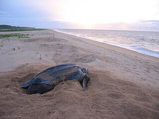
The Amana Nature Reserve is a nature reserve in French Guiana, France. It has been protected because it is one of the world's largest leatherback sea turtle nesting sites. It is part of the communes of Awala-Yalimapo and Mana.

The Coesewijne River is a blackwater river in Suriname. It is a tributary of the Coppename River and flows into the Coppename south of Boskamp. The river has its source in the Goliath Mountain.
Marijkedorp is a village of indigenous Lokono people in the Albina resort of the Marowijne District of Suriname. Grace Watamaleo has been the village captain since 2011.

