
Saramacca is a district of Suriname, in the north. Saramacca's capital city is Groningen, with other towns and cities including Batavia, Kampong Baroe, Uitkijk, Maho and Boskamp. Saramacca has a population of 17,480 and an area of 3,636 km2.

Sipaliwini is the largest district of Suriname, located in the south. Sipaliwini is the only district that does not have a regional capital, as it is directly administered by the national government in Paramaribo. Sipaliwini District includes disputed areas, with the southwestern region controlled and administered by Guyana, whereas the southeastern region is controlled by French Guiana.

Nieuw Nickerie is the third largest city in Suriname with a population estimated at 12,818. It is the capital city of the Nickerie district, and the terminus of the East-West Link.

The Central Suriname Nature Reserve is a conservation unit in Suriname. It preserves an area of tropical rainforest. The reserve is in pristine condition.

Brownsweg is a town and resort in Suriname in the Brokopondo District. Its population at the 2012 census was 4,793.

Oostelijke Polders is a resort in Suriname located in the Nickerie District. Its population at the 2012 census was 7,153. Villages in the resort include Glasgow, Hamptoncourtpolder, and Paradise. Oostelijke Polders is an agricultural area with a focus on rice production. Oostelijke Polder has a clinic and a school.
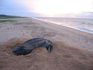
Galibi is a resort in Suriname, located in the Marowijne District. Its population at the 2012 census was 741. Galibi is a tribal area inhabited by an indigenous population of Kalina Amerindians.

Brownsberg Nature Park is a nature park located in Suriname. The site measures 12,000 ha and is located in the district of Brokopondo around 130 km south from the capital city Paramaribo. The 500-meter high Brownsberg is the central point of the park. The site is located near the Brokopondo Reservoir. The park is managed by STINASU. Often the people of Suriname use the word Brownsberg as simple variant of Brownsberg Nature Park. Local people also write it as Bruijnsberg, pronounced as Braynsberg.
The biodiversity of Suriname is high, mostly because of the variety of habitats and warm temperatures. The average annual temperature in the coastal area is between 26° and 28°C. Suriname can be divided into four major ecological zones, namely from north to south;
- The young coastal plain
- The old coastal plain
- The Savannah or Zanderij belt
- The interior residual uplands

The Sipaliwini Savanna is a protected area and nature reserve in Suriname. The reserve is located to the south of the Sipaliwini River in the far south of the country. The reserve measures 100,000 hectares, and has been a protected area since 1972. The majority of the reserve consists of a savannah which in turn is a continuation of the Brazilian Tumucumaque Mountains National Park. The reserve is in pristine condition with almost no human habitation.

Maripaston was a village situated in the Bigi Poika resort of the Para District, Suriname. The village was located along the Saramacca River and used to be the main village of the Matawai maroons, a group of descendants of African slaves who escaped and formed their own communities in the interior of Suriname.
Alfonsdorp is a village of indigenous Lokono people in the Albina resort of the Marowijne District of Suriname. The village is located on the East-West Link. The Wanekreek Nature Reserve is located near the village.

The Coppename Monding Nature Reserve is a protected area and nature reserve in Suriname. The reserve is located near the mouth of the Coppename River. The reserve measures 12,000 hectares, and has been a protected area since 1961.
The Brinckheuvel Nature Reserve is a protected area and nature reserve in Suriname. The reserve is located on the Saramacca River, and is the most southern savannah of the Savannah Belt. The Mindrineti River flows through the reserve. The reserve measures 6,000 hectares, and has been a protected area since 1961.
The Copi Nature Reserve is a protected area and nature reserve in Suriname. The reserve is located along the blackwater Cassewinica Creek. The reserve measures 18,000 hectares, and has been a protected area since 1986.

Brownsberg is a 515 metres high mountain in the Brokopondo District of Suriname. It is the namesake of the Brownsberg Nature Park. The mountain has been named after John Brown, a 19th-century gold miner.

The Amana Nature Reserve is a nature reserve in French Guiana, France. It has been protected because it is one of the world's largest leatherback sea turtle nesting sites. It is part of the communes of Awala-Yalimapo and Mana.

The Coesewijne River is a blackwater river in Suriname. It is a tributary of the Coppename River and flows into the Coppename south of Boskamp. The river has its source in the Goliath Mountain.
Marijkedorp is a village of indigenous Lokono people in the Albina resort of the Marowijne District of Suriname. Grace Watamaleo has been the village captain since 2011.


