
The Republic of Suriname has a number of forms of transport. Transportation emissions are an increasing part of Suriname's contributions to climate change, as part of the Nationally Determined Contributions for the Paris Agreement, Suriname has committed to emissions controls for vehicles and increased public transit investment.

Paramaribo is the capital and largest city of Suriname, located on the banks of the Suriname River in the Paramaribo District. Paramaribo has a population of roughly 241,000 people, almost half of Suriname's population. The historic inner city of Paramaribo has been a UNESCO World Heritage Site since 2002.

Fort Zeelandia is a fortress in Paramaribo, Suriname. In 1640 the French built a wooden fort on the spot which, during British colonial period, was reinforced and became Fort Willoughby. It was taken by the Dutch in 1667 and renamed Fort Zeelandia.
Commewijne is a district of Suriname, located on the right bank of the Suriname River. Commewijne's capital city is Nieuw Amsterdam. Tamanredjo is another major town, while Meerzorg is the most populated.

Jodensavanne was a Jewish plantation community in Suriname, South America, and was for a time the centre of Jewish life in the colony. It was established in the 1600s by Sephardi Jews and became more developed and wealthy after a group of Jews fleeing persecution in Brazil settled there in the 1660s. It was located in what is now Para District, about 50 km (31 mi) south of the capital Paramaribo, on the Suriname River. Sugarcane plantations were established by forcing Black African people to work as slaves. At its height in around 1700, Jodensavanne was home to roughly 500 plantation owners and 9000 enslaved people. The colony faced regular attacks from Indigenous people, slave revolts, and even raids from the French navy. The community eventually relocated to the capital of Paramaribo. Clearing of grave sites and maintenance of the synagogue ruins has been attempted at various times from the 1940s to the 21st century.

Nieuw Amsterdam is the capital of the Commewijne District in Suriname. It is a small coastal town situated at the confluence of the Suriname River and Commewijne River, just across from Paramaribo, the country's capital. Its population at the 2012 census was 5,650, with around 1,200 people living in the main town, most of whom are of Javanese and East Indian origin. It is the location of the historical Fort Nieuw-Amsterdam, today an open-air museum. The town of Mariënburg with former sugarcane factory is located 3 km from Nieuw Amsterdam and part of the resort.

The Suriname River is 480 kilometres (300 mi) long and flows through the country of Suriname. Its sources are located in the Guiana Highlands on the border between the Wilhelmina Mountains and the Eilerts de Haan Mountains. The source of the Upper Suriname River is at the confluence of the Gran Rio and Pikin Rio near the village of Goddo. The river continues shortly after the reservoir along Brokopondo as the Lower Suriname River. Than it flows Berg en Dal, the migrant communities Klaaskreek and Nieuw-Lombé, Jodensavanne, Carolina, Ornamibo and Domburg, before reaching the capital Paramaribo on the left bank and Meerzorg on the right bank. At Nieuw-Amsterdam it is joined by the Commewijne and immediately thereafter at the sandspit Braamspunt it flows into the Atlantic Ocean.

Commewijne River is a river in northern Suriname.

Tapanahoni is a resort in Suriname, located in the Sipaliwini District. Its population at the 2012 census was 13,808. Tapanahoni is a part of Sipaliwini which has no capital, but is directly governed from Paramaribo. Tapanahony is an enormous resort which encompasses a quarter of the country of Suriname. The most important town is Diitabiki which is the residence of the granman of the Ndyuka people since 1950, and the location of the oracle.

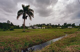
Meerzorg is a town and resort (municipality) in Suriname, located on the eastern bank of the Suriname River, directly opposite the capital Paramaribo. Its population at the 2012 census was 12,405. Since 2000 it has been connected to Paramaribo by the Jules Wijdenbosch Bridge, named after the former President Jules Wijdenbosch.

Johan & Margaretha or sometimes just Margaretha is a resort in Suriname, located in the Commewijne District. Its population at the 2012 census was 756. It is located along a peninsula northeast of Paramaribo. It is named after the coffee plantation Johan & Margaretha which was founded in 1745 by Johan Knöffel. It is safe to assume that his wife was called Margaretha.
Galibi is a resort in Suriname, located in the Marowijne District. Its population at the 2012 census was 741. Galibi is a tribal area inhabited by an indigenous population of Kalina Amerindians.

Domburg is a resort in the Wanica District of Suriname, located on the northern coast of South America. Its population at the 2012 census was 5,661.

The Cassard expedition was a sea voyage by French Navy captain Jacques Cassard in 1712, during the War of the Spanish Succession. Targeting English, Dutch, and Portuguese possessions, he raided and ransomed the colonies of Cape Verde, Sint Eustatius, and Curaçao—factories, depots, and seasoning camps used in the Atlantic slave trade. He also raided and ransomed Montserrat, Antigua, Surinam, Berbice, and Essequibo—wealthy sugar-producing colonies in the Caribbean whose economies were based on the exploitation of slave labor.

Fort Nieuw-Amsterdam is a fort in Suriname built from 1734 to 1747 at the confluence of the Suriname and Commewijne rivers. It is open to the public as an open-air museum.
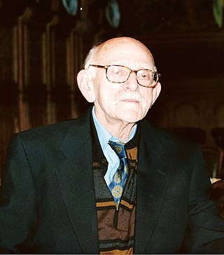
Hugo Pos was a Surinamese judge, writer, and poet.

The Ferry terminal Leonsberg is a ferry jetty in the north of Paramaribo, Suriname. From here various private operators offer transport service the other side of the Suriname river and the Commewijne River.

Fort Sommelsdijk was a fort in Suriname built in 1686 at the confluence of the Commewijne and Cottica rivers. Later it was used as a mission post and hospital. In 1870, it lost its function and was only used a military outpost. In the 21st century, the fort was taken over by nature.

Willem Benjamin van Panhuys was a Dutch army officer, planter and colonial administrator who served as the governor of Suriname from 27 February 1816 until his death on 18 July.

