Regions of Guyana

Last updated

Guyana regions numbered (GINA).png Guyana regions english.png
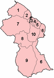
Regions of Guyana by number and name

Guyana is divided into 10 regions: [1] [2]

No.RegionArea
(km2)
Pop.
(2012)
Pop.
per km2
Capital
1 Barima-Waini 20,33926,9411.3 Mabaruma
2 Pomeroon-Supenaam 6,19546,8107.6 Anna Regina
3 Essequibo Islands-West Demerara 3,755107,41628.6 Vreed en Hoop
4 Demerara-Mahaica 2,232313,429140.4 Triumph [3] [4]
5 Mahaica-Berbice 4,19049,72311.9 Fort Wellington
6 East Berbice-Corentyne 36,234109,4313.0 New Amsterdam
7 Cuyuni-Mazaruni 47,21320,2800.4 Bartica
8 Potaro-Siparuni 20,05110,1900.5 Mahdia
9 Upper Takutu-Upper Essequibo 57,75024,2120.4 Lethem
10 Upper Demerara-Berbice 17,04039,4522.3 Linden
 Guyana214,999747,8843.5 Georgetown

Each Region is administered by a Regional Democratic Council (RDC) which is headed by a Chairman. The Regions are divided into neighbourhood councils, known as Neighbourhood Democratic Councils (NDCs). [5]

Contents

The current regional structure was established by the Local Democratic Organs Act in 1980. The hyphenated names indicate the name of the rivers that define their border. [6]

Historical divisions

Previous regional names: [7] [8]

Regions of Guyana (1971)

Regions of British Guiana (1958)

Colonial counties (before 1958)

See also

Related Research Articles

<span class="mw-page-title-main">Politics of Guyana</span>

The politics of Guyana takes place in a framework of a representative democratic assembly-independent republic, whereby the President of Guyana is the head of government and of a multi-party system. Executive power is exercised by the President, advised by a cabinet. Legislative power is vested in both the President and the National Assembly of Guyana. The judiciary is independent of the executive and the legislature.

The transport sector comprises the physical infrastructure, docks and vehicle, terminals, fleets, ancillary equipment and service delivery of all the various modes of transport operating in Guyana. The transport services, transport agencies providing these services, the organizations and people who plan, build, maintain, and operate the system, and the policies that mold its development.

The Geography of Guyana comprises the physical characteristics of the country in Northern South America and part of Caribbean South America, bordering the North Atlantic Ocean, between Suriname and Venezuela, with a land area of approximately 214,969 square km. The country is situated between 1 and 9 north latitude and between 56 and 62 west longitude. With a 459 km (285 mi)-long Atlantic coastline on the northeast, Guyana is bounded by Venezuela on the west, Brazil on the west and south, and Suriname on the east.

<span class="mw-page-title-main">Demerara</span> 1745–1803 Dutch colony in South America

Demerara is a historical region in the Guianas, on the north coast of South America, now part of the country of Guyana. It was a colony of the Dutch West India Company between 1745 and 1792 and a colony of the Dutch state from 1792 until 1815. It was merged with Essequibo in 1812 by the British who took control. It formally became a British colony in 1815 until Demerara-Essequibo was merged with Berbice to form the colony of British Guiana in 1831. In 1838, it became a county of British Guiana until 1958. In 1966, British Guiana gained independence as Guyana and in 1970 it became a republic as the Co-operative Republic of Guyana. It was located around the lower course of the Demerara River, and its main settlement was Georgetown.

<span class="mw-page-title-main">The Guianas</span> Region in north-central South America

The Guianas, also spelled Guyanas or Guayanas, is a region in north-eastern South America. Strictly, the term refers to the three Guyanas: Guyana, Suriname and French Guiana, formerly British, Dutch and French Guyana. Broadly it refers to the South American coast from the mouth of the Oronoco to the mouth of the Amazon.

<span class="mw-page-title-main">Cuyuni-Mazaruni</span> Region of Guyana

Cuyuni-Mazaruni is a region of Guyana. Its capital is Bartica, with villages including Issano, Kartabo, Kamarang, and Imbaimadai.

<span class="mw-page-title-main">East Berbice-Corentyne</span> Region of Guyana

East Berbice-Corentyne is one of ten regions in Guyana covering the whole of the east of the country. It borders the Atlantic Ocean to the north, the Nickerie District and Sipaliwini District of Suriname to the east, Brazil to the south and the regions of Mahaica-Berbice, Upper Demerara-Berbice, Potaro-Siparuni and Upper Takutu-Upper Essequibo to the west.

<span class="mw-page-title-main">Demerara-Mahaica</span> Region of Guyana

Demerara-Mahaica is a region of Guyana, bordering the Atlantic Ocean to the north, the region of Mahaica-Berbice to the east, the region of Upper Demerara-Berbice to the south and the region of Essequibo Islands-West Demerara to the west.

<span class="mw-page-title-main">Essequibo Islands-West Demerara</span> Region of Guyana

Essequibo Islands-West Demerara is a region of Guyana. It is situated around the Essequibo River, the largest river in Guyana that lies between the Orinoco and Amazon rivers of South America.

<span class="mw-page-title-main">Upper Demerara-Berbice</span> Region of Guyana

Upper Demerara-Berbice is a region of Guyana, bordering the regions of Essequibo Islands-West Demerara, Demerara-Mahaica and Mahaica-Berbice to the north, the region of East Berbice-Corentyne to the east, and the regions of Potaro-Siparuni and Cuyuni-Mazaruni to the west.

<span class="mw-page-title-main">Potaro-Siparuni</span> Region of Guyana

Potaro-Siparuni is a region of Guyana. It borders the region of Cuyuni-Mazaruni to the north, the regions of Upper Demerara-Berbice and East Berbice-Corentyne to the east, the region of Upper Takutu-Upper Essequibo to the south and Brazil to the west.

<span class="mw-page-title-main">Upper Takutu-Upper Essequibo</span> Region of Guyana

Upper Takutu-Upper Esequibo is a region of Guyana. It borders the region of Potaro-Siparuni to the north, the region of East Berbice-Corentyne to the east and Brazil to the south and west. It contains the town of Lethem, and the villages of Aishalton, Nappi and Surama. It is also the largest region of Guyana.

<span class="mw-page-title-main">Essequibo (colony)</span> 1616–1803 Dutch colony in South America

Essequibo was a Dutch colony in the Guianas and later a county on the Essequibo River in the Guiana region on the north coast of South America. It was a colony of the Dutch West India Company between 1616 and 1792 and a colony of the Dutch state from 1792 until 1815. It was merged with Demerara in 1812 by the British who took control. It formally became a British colony in 1815 until Demerara-Essequibo was merged with Berbice to form the colony of British Guiana in 1831. In 1838, it became a county of British Guiana till 1958. In 1966, British Guiana gained independence as Guyana and in 1970 it became a republic as the Co-operative Republic of Guyana. It was located around the lower course of the Essequibo River.

<span class="mw-page-title-main">Guyana</span> Caribbean country in South America

Guyana, officially the Co-operative Republic of Guyana, is a country on the northern coast of South America, part of the historic mainland British West Indies. Guyana is an indigenous word which means "Land of Many Waters". Georgetown is the capital of Guyana with the largest population. Guyana is bordered by the Atlantic Ocean to the north, Brazil to the south and southwest, Venezuela to the west, and Suriname to the east. With a land area of 214,969 km2 (83,000 sq mi), Guyana is the third-smallest sovereign state by area in mainland South America after Uruguay and Suriname, and is the second-least populous sovereign state in South America after Suriname; it is also one of the least densely populated countries on Earth. It has a wide variety of natural habitats and very high biodiversity. The country also hosts one part of the Amazon rainforest, the largest tropical rainforest in the world.

The Guyana Cricket Board is the ruling body for cricket in Guyana.

<span class="mw-page-title-main">Pomeroon (colony)</span> Dutch colony in Guyana

Pomeroon is the name of a former Dutch plantation colony on the Pomeroon River in the Guyana region on the north coast of South America. After early colonization attempts in the late 16th century were attacked by Spaniards and local Indians, the original inhabitants fled the interior of Guyana, founding the colony of Essequibo around Fort Kyk-Over-Al shortly after. A second, and more serious attempt at colonization started in 1650, but was ultimately unsuccessful, as French privateers destroyed the colony in 1689. In the late 18th century, a third attempt of colonization was started, this time under the jurisdiction of the Essequibo colony.

Fairview (Kurupukari) is an indigenous settlement on the Essequibo River, in the Upper Demerara-Berbice region of Guyana. It is the entry point to the Iwokrama Forest. Former president David A. Granger once referred to Iwokrama as the "green heart of Guyana."

Paradise is a village located in the Demerara-Mahaica region of Guyana, and used to be its regional capital, however the administrative building burnt down in 2006, and the regional capital moved to Triumph.

<span class="mw-page-title-main">Fauna of Guyana</span> Animals of Guyana

The fauna of Guyana comprises all the animal species inhabiting the country of Guyana, which is part of the neotropical realm. Guyana has many endemic species and one of the highest biodiversity rates in the world as a result of the majority of the country being part of the Amazon rainforest, and as a result a large amount of the species being types of frogs or spiders. Guyana's has three distinct main biomes are tropical rainforests, wetlands, and savannas, and each biome has unique fauna associated.

References

  1. Bureau of Statistics - Guyana Archived 2012-02-17 at the Wayback Machine , CHAPTER III: POPULATION REDISTRIBUTION AND INTERNAL MIGRATION, Table 3.4: Population Density, Guyana: 1980 - 2002
  2. Guyana - Government Information Agency Archived 2007-08-14 at the Wayback Machine , National Profile
  3. "Region Four RDC office moves to Triumph". Stabroek News. Retrieved 18 August 2020.
  4. "Regional Democratic Council Region No. 4 - Demerara/Mahaica, Guyana". Regional Democratic Council Region No. 4via Facebook. Retrieved 18 August 2020.
  5. Government of Guyana, Statistics
  6. "THE LOCAL DEMOCRATIC ORGANS ACT 1980" (PDF). parliament.gov.g. 7 October 1980. Retrieved 2020-01-03.
  7. "Internal Administrative Divisions of British Guiana" (PDF). Cia.gov. 29 August 1958. Archived from the original (PDF) on January 22, 2017. Retrieved 2020-01-03.
  8. "ADMIN REGIONS DETAILED – GUYANA LANDS AND SURVEYS COMMISSION'S FACT PAGE ON GUYANA" . Retrieved 2021-03-16.