Barima-Waini

Last updated
Barima-Waini
Region 1
Administrative region
Coconut Trees on the Shell Beach - panoramio.jpg
Flag yellow green 5x3.svg
Barima-Waini in Guyana.svg
Map of Guyana showing Barima-Waini region
CountryFlag of Guyana.svg  Guyana
Regional Capital Mabaruma
Area
  Total20,399 km2 (7,876 sq mi)
Population
 (2012 census)
  Total26,941
  Density1.3/km2 (3.4/sq mi)
[1]

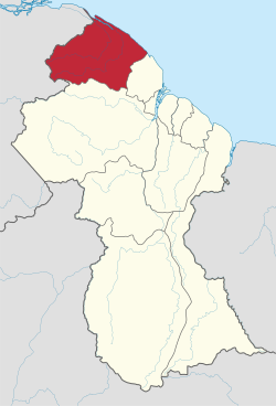
Barima-Waini (Region 1) is a region of Guyana and is located in the northwest of the country. Barima-Waini has three sub-regions: Mabaruma, Matakai, and Moruca. [2]

Contents

The region is located in the northwest of the country and has a population of 26,941. [3] It covers an area of 20,339 square kilometres (7,853 sq mi). It borders the Atlantic Ocean to the north, the region of Pomeroon-Supenaam to the east, the region of Cuyuni-Mazaruni to the south and Venezuela to the west. [1]

History

Prior to the 1980 administrative reform in Guyana, the Barima-Waini Region was known as the 'North West district'. [4]

Mabaruma became the administrative centre when it was decided that the former centre, Morawhanna, was too susceptible to flooding. [5]

Etymology

The region is named after two rivers that flow through the region: the Barima River and the Waini River.

Geography

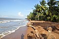
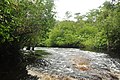
Barima-Waini is a heavily forested region. The Atlantic coastal strip of Region One features a number of beaches, including, from west to east, Almond Beach, Luri Beach, Shell Beach, Turtle Beach, Foxes Beach, Iron-punt Beach, Pawpaw Beach and Father's Beach. Marine turtles nest on some of these beaches. There are also a number of Amerindian communities in this area, including Santa Rosa Mission.

Economy

The main economic activities in the Barima-Waini region are forestry and gold mining. [1] The northern and northeastern sections include thousands of acres of rich alluvial soil, whose main crops include coffee, ground provisions (such as cassava, eddoes and yams), cabbage, beans, corn, peanuts, and citrus fruits. (This is the area which supplies the famous Pomeroon cassareep.[ clarification needed ])

The Matthews Ridge-Port Kaituma manganese industry was discontinued in 1968 [6] when falling world prices made it uneconomical to continue. Mining was resumed as of 2011. [7]

Major settlements, services and facilities

The Mabaruma sub-region includes the region's capital of Mabaruma, as well as Barabina, Hosororo, Wauna, Kumaka, [8] White Water and Kamwatta. [9]

Moruca sub-region includes Waramuri, Warapoka, Santa Cruz, Kokerite, Chinese Landing, Kwebena and Santa Rosa, [2] and Haimacabra. [9]

Matakai sub-region includes Sebai, [9] Port Kaituma, Matthew's Ridge, Baramita, [10] Arakaka, [11] and Morawhanna. [12]

The region has two secondary schools, North West Secondary School in Mabaruma, established in 1965, and Santa Rosa Secondary School, established in 1992.

Population

The Government of Guyana has administered four official censuses since the 1980 administrative reforms, in 1980, 1991, 2002, and 2012. [13] In 2002, the population of Barima-Waini was recorded at 24,275 people. [14] Official census records for the population of Barima-Waini are as follows:

1980199120022012
18,32918,42824,27526,941

Communities

Communities (including name variants): [15]

Territorial claim

Venezuela has renewed its claim to the Essequibo region which is situated west of the Essequibo river. [16] The status of the border controversy is subject to the Geneva Agreement, which was signed by the United Kingdom, Venezuela and British Guiana on February 17, 1966. As of December 2020, the matter is being addressed by the ICJ. [17]

See also

Related Research Articles

<span class="mw-page-title-main">Port Kaituma</span> Place in Barima-Waini, Guyana

Port Kaituma is a small village within the Barima-Waini administrative region of Guyana. It became known internationally as a gateway village to the Peoples Temple settlement in nearby Jonestown. It has long been a hub for mining in the area.

Matthews Ridge is a small village within the Barima-Waini administrative region of Guyana. The village name comes from the name of a public official, Matthew Young, as well as the ridges in the area. The village is divided into three sections, Heaven's Hill, Hell Hill and the valley.

<span class="mw-page-title-main">Mabaruma</span> Town and regional capital in Barima-Waini, Guyana

Mabaruma is the administrative centre and regional capital for Region One (Barima-Waini) of Guyana. It is located close to the Aruka River on a narrow plateau above the surrounding rainforest at an elevation of 13 metres.

<span class="mw-page-title-main">Cuyuni-Mazaruni</span> Region of Guyana

Cuyuni-Mazaruni is a region of Guyana. Its capital is Bartica, with villages including Issano, Kartabo, Kamarang, and Imbaimadai.

<span class="mw-page-title-main">East Berbice-Corentyne</span> Region of Guyana

East Berbice-Corentyne is one of ten regions in Guyana covering the whole of the east of the country. It borders the Atlantic Ocean to the north, the Nickerie District and Sipaliwini District of Suriname to the east, Brazil to the south and the regions of Mahaica-Berbice, Upper Demerara-Berbice, Potaro-Siparuni and Upper Takutu-Upper Essequibo to the west.

<span class="mw-page-title-main">Pomeroon-Supenaam</span> Region of Guyana

Pomeroon-Supenaam is a region of Guyana. It borders the Atlantic Ocean to the north, the region of Essequibo Islands-West Demerara to the east, the region of Cuyuni-Mazaruni to the south and the region of Barima-Waini to the west. Pomeroon-Supenaam contains the town of Anna Regina and the villages of Charity, Pickersgill, Spring Garden and Suddie. In 2012, an Official Census by the Government of Guyana listed the population of the Pomeroon-Supenaam Region at 46,810.

<span class="mw-page-title-main">Potaro-Siparuni</span> Region of Guyana

Potaro-Siparuni is a region of Guyana. It borders the region of Cuyuni-Mazaruni to the north, the regions of Upper Demerara-Berbice and East Berbice-Corentyne to the east, the region of Upper Takutu-Upper Essequibo to the south and Brazil to the west.

<span class="mw-page-title-main">Santa Rosa, Guyana</span> Place in Barima-Waini, Guyana

Santa Rosa is a community in the Barima-Waini region of northern Guyana. Santa Rosa mission was established in 1840, and is one of the earliest Catholic Missions in Guyana. The village is part of the North West Amerindian District.

The Moruka River or Moruca River is a river in the Barima-Waini region of northern Guyana.

Assakata or Asakata is a village in Barima-Waini region, in the north of Guyana. Assakata is an Amerindian village inhabited by Warao and Arawak people, located in the swamps and marshes between the Barima and Pomeroon River.

Baramita, is a community in the Barima-Waini region of northern Guyana, standing about 20 miles west of Matthew's Ridge, at an altitude of 99 metres.

Hosororo is a community in the Barima-Waini region of northern Guyana, on the west bank of the Aruka River, 10 km (6.2 mi) from the river's mouth, and three miles from Mabaruma.

<span class="mw-page-title-main">Waini River</span> River in Barima-Waini, Guyana

The Waini River is a river in the Barima-Waini region of northern Guyana. It flows into the Atlantic Ocean near the border with Venezuela. The upper portion of the river flows through the Guianian moist forests, while the lower Waini river flows through the eastern extent of the vast Orinoco Delta swamp forests before emptying into the sea.

Arakaka is a community in the Barima-Waini region of Guyana, standing on the Barima River and 12 miles southerly of Port Kaituma, at an altitude of 63 metres (209 feet).

<span class="mw-page-title-main">Barima River</span> River in Guyana, Venezuela

The Barima River is a tributary of the Orinoco River, entering 6 kilometres (4 mi) from the Atlantic Ocean. It originates from the Imataka Mountains in Guyana, flowing for approximately 340 kilometres (210 mi) before entering Venezuela about 80 kilometres (50 mi) from its mouth.

Port Kaituma Community School (PKCS) is a learning centre in Port Kaituma within the Barima-Waini administrative region of Guyana.

The Kaituma River is a river of Guyana in the Barima-Waini region. The mouth is at the upper Barima River, and the area is made up of mostly mangrove swamps.

Morawhanna is a small Atlantic coast village in Guyana, on the left side of the Barima River and in close proximity to Venezuela.

Whitewater is a village in the Barima-Waini Region of Guyana. Whitewater is located close to the border with Venezuela and is inhabited by Warao Amerindians.

References

  1. 1 2 3 Macmillan Publishers (2009). "Administrative Regions - 1 and 7". Macmillan Junior Atlas: Guyana. Oxford: Macmillan Caribbean. p. 36. ISBN   9780333934173.
  2. 1 2 "Moruca's needs can no longer be met by fishing, subsistence farming". Stabroek News. 2017-03-31. Retrieved 2021-01-19.
  3. "District 1: Barima-Waini". Caribbean Elections. Retrieved 2022-06-23.
  4. UK Directorate of Overseas Surveys 1:500,000 map of Guyana NW sheet, 1966.
  5. "Emanuel Chan-A-Sue, MS". Stabroek News via Land of Six People. Retrieved 19 August 2020.
  6. "Miners thrilled with Matthews Ridge manganese find". Kaieteur News Online. 23 July 2013. Retrieved 19 August 2020.
  7. "Guyana Aims to Become a Top Manganese Producer". Investing News. 24 May 2012. Retrieved 19 August 2020.
  8. "The Mabaruma Sub-Region". Stabroek News. 2010-11-14. Retrieved 2021-01-19.
  9. 1 2 3 "CH&PA to begin selecting beneficiaries, promoting new hinterland housing project | Ministry of Local Government and Regional Development" . Retrieved 2021-01-19.
  10. "Matakai education sector bolstering amidst challenges – DEO". Department of Public Information. 2017-10-30. Retrieved 2021-01-19.
  11. "Joint Services rank among several held following Matthew's Ridge robbery". Guyana Chronicle. Retrieved 2021-01-19.
  12. "Overseas-based investor resuscitating Morawhanna fish complex, fuel farm". Stabroek News. 2012-07-21. Retrieved 2021-01-19.
  13. Beaie, Sonkarley Tiatun (19 September 2007). "Chapter 3: National Redistribution and Internal Migration" (PDF). 2002 Population and Housing Census - Guyana National Report. Bureau of Statistics. p. 51. Archived from the original (PDF) on 17 February 2012. Retrieved 29 August 2012.
  14. Beaie, Sonkarley Tiatun (19 September 2007). "National Population Trends: Size, Growth and Distribution" (PDF Download). 2002 Population and Housing Census - Guyana National Report. Bureau of Statistics. p. 25. Retrieved 29 August 2012.
  15. "2012 Population by Village". Statistics Guyana. Retrieved 6 December 2021.
  16. "Official Announcements". Archived from the original on 8 September 2016. Retrieved 28 July 2016.
  17. Summary of the Judgement of 18 December 2020

7°40′01″N59°45′00″W / 7.667°N 59.750°W / 7.667; -59.750