
Barima-Waini is a region of Guyana. Venezuela claims the territory as part of Guayana Esequiba.

Port Kaituma is a small village within the Barima-Waini administrative region of Guyana. It became known internationally as a gateway village to the Peoples Temple settlement in nearby Jonestown. It has long been a hub for mining in the area.
Matthews Ridge is a small village within the Barima-Waini administrative region of Guyana. The village name comes from the name of a public official, Matthew Young, as well as the ridges in the area. The village is divided into three sections, Heaven's Hill, Hell Hill and the valley.

Mabaruma is the administrative centre for Region One (Barima-Waini) of Guyana. It is located close to the Aruka River on a narrow plateau above the surrounding rainforest at an elevation of 13 metres.

Cuyuni-Mazaruni is a region of Guyana. Venezuela claims the territory as part of Guayana Esequiba.

Pomeroon-Supenaam is a region of Guyana. It borders the Atlantic Ocean to the north, the region of Essequibo Islands-West Demerara to the east, the region of Cuyuni-Mazaruni to the south and the region of Barima-Waini to the west. Pomeroon-Supenaam contains the town of Anna Regina and the villages of Charity, Pickersgill, Spring Garden and Suddie. In 2012, an Official Census by the Government of Guyana listed the population of the Pomeroon-Supenaam Region at 46,810.
Kamwatta Hill is a community in the Barima-Waini Region, in northern Guyana. Kamwatta is an Amerindian village inhabited by Warao and Arawak people.
Santa Rosa is a community in the Barima-Waini region of northern Guyana. Santa Rosa mission was established in 1840, and is one of the earliest Catholic Missions in Guyana. The village is part of the North West Amerindian District.
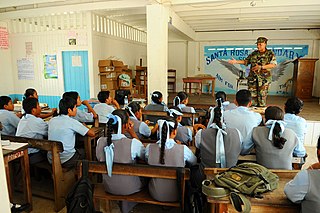
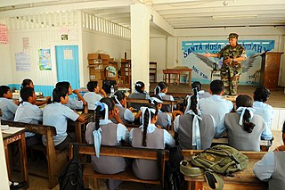
Santa Rosa Secondary School is a secondary school in Santa Rosa, in the Barima-Waini region of northern Guyana. The school was established in 1991, making it the second secondary school in the area after the establishment of North West Secondary School in 1965. Prospective students undergo competitive examination and may take their Caribbean Examinations Council (CXC) examinations upon graduation. As of 2009, the school taught over 650 students, up from 264 in 2005. Of these 264, 72 of whom were housed in a dormitory sponsored by the Inter-American Development Bank. A third wing was built in 2009, adding nine new classrooms to the school. Jonny La'go Payne assumed the role of headmaster in 2005.
Assakata or Asakata is a village in Barima-Waini region, in the north of Guyana. Assakata is an Amerindian village inhabited by Warao and Arawak people, located in the swamps and marshes between the Barima and Pomeroon River.

Kumaka is a community in Barima-Waini region, in northern Guyana.
Baramita, is a community in the Barima-Waini region of northern Guyana, standing about 20 miles west of Matthew's Ridge, at an altitude of 99 metres.
Hosororo is a community in the Barima-Waini region of northern Guyana, on the west bank of the Aruka River, 10 km (6.2 mi) from the river's mouth, and three miles from Mabaruma.

The Waini River is a river in the Barima-Waini region of northern Guyana. It flows into the Atlantic Ocean near the border with Venezuela. The upper portion of the river flows through the Guianian moist forests, while the lower Waini river flows through the eastern extent of the vast Orinoco Delta swamp forests before emptying into the sea.
Arakaka is a community in the Barima-Waini region of Guyana, standing on the Barima River and 12 miles southerly of Port Kaituma, at an altitude of 63 metres (209 feet).
Koriabo is a community in the Barima-Waini region of Guyana, standing at an altitude of 36 metres. Barima and Koriba form an Amerindian community which is mainly inhabited by Warao people with a minority of Arawak and Kalina people.
Port Kaituma Community School (PKCS) is a learning centre in Port Kaituma within the Barima-Waini administrative region of Guyana.
The Barama River is a tributary of the Waini River, both being in the Barima-Waini administrative region of Guyana.
The Kaituma River is a river of Guyana in the Barima-Waini region. The mouth is at the upper Barima River, and the area is made up of mostly mangrove swamps.
Whitewater is a village in the Barima-Waini Region of Guyana. Whitewater is located close to the border with Venezuela and is inhabited by Warao Amerindians.
