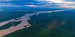
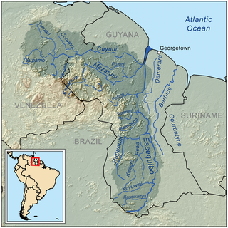
The Essequibo River is the largest river in Guyana, and the largest river between the Orinoco and Amazon. Rising in the Acarai Mountains near the Brazil–Guyana border, the Essequibo flows to the north for 1,014 kilometres (630 mi) through forest and savanna into the Atlantic Ocean. With a total drainage basin of 156,828 square kilometres (60,552 sq mi) and an average discharge of 4,531–5,650 cubic metres per second (160,000–199,500 cu ft/s).

Guyana is divided into 10 regions:
The Rupununi is a region in the south-west of Guyana, bordering the Brazilian Amazon. The Rupununi river, also known by the local indigenous peoples as Raponani, flows through the Rupununi region. The name Rupununi originates from the word rapon in the Makushi language, in which it means the black-bellied whistling duck found along the river.

The Kanuku Mountains are a group of mountains in Guyana, located in the Upper Takutu-Upper Essequibo region. The name means 'forest' in the Wapishana language, a reference to the rich diversity of wildlife found there. The Eastern Kanuku Mountains and the Western Kanuku Mountains are separated by the Rupununi River. In 2011, the mountains were designated National Protected Area.

The Rupununi savannah is a savanna plain in Guyana, in the Upper Takutu-Upper Essequibo region. It is part of the Guianan savanna ecoregion of the tropical and subtropical grasslands, savannas, and shrublands biome.

The Macushi are an indigenous people living in the borderlands of southern Guyana, northern Brazil in the state of Roraima, and in an eastern part of Venezuela.
Achiwib is a village in the Upper Takutu-Upper Essequibo Region of Guyana. Achiwib is an Amerindian community that borders Brazil, the main language spoken in the village is Wapishana language.
Dadanawa Ranch is located on the Rupununi River in the Rupununi savannah in the Upper Takutu-Upper Essequibo Region of Guyana. It is the largest and one of the most isolated cattle ranches in Guyana.

The grey antbird is a species of bird in the antbird family Thamnophilidae. It is found in Bolivia, Brazil, Colombia, Ecuador, French Guiana, Guyana, Peru, Suriname, and Venezuela. Its natural habitat is subtropical or tropical moist lowland forests.

The oriole blackbird is a species of bird in the family Icteridae. Its genus, Gymnomystax, is monotypic. It is a medium-sized yellow and black bird found in Brazil, Colombia, Ecuador, French Guiana, Guyana, Peru, Suriname, and Venezuela, where its natural habitats are subtropical or tropical moist lowland forest, subtropical or tropical moist shrubland, subtropical or tropical seasonally wet or flooded lowland grassland, and swamps.

McConnell's flycatcher is a species of bird in the tyrant flycatcher family Tyrannidae. It is found in the Guiana Shield, northern Brazil, Peru and Bolivia. Its natural habitats are subtropical or tropical moist lowland forests and subtropical or tropical moist montane forests.

The coraya wren is a species of bird in the family Troglodytidae, the wrens.
The Kassikaityu River is a tributary of the Essequibo River of Guyana.
The North Rupununi District in located in south-west Guyana consisting of a mixture of forest, savannah and wetlands ecosystems and is considered one of the most diverse areas in South America. Located on the eastern margin of the larger savannah system which extends into Brazil and is separated by the Ireng and Takutu rivers that come together to form the Rio Branco. The Guyana Rupununi system is divided into the North and South Rupununi by the Kanuku Mountains.
Surama is an Amerindian village in the North Rupununi area and the Upper Takutu-Upper Essequibo Region of Guyana, with a population of 274 people as of 2012.

Charles Barrington Brown was a Canadian geologist and explorer. On April 24, 1870, he was one of two English-based geologists appointed government surveyors to the colony of British Guiana. That same year, he was the first Westerner to see Kaieteur Falls. The other surveyor was James Sawkins.

Edwina Melville (1926–1993) was a Guyanese writer, teacher, politician and advocate of the first-nation Wapishana peoples of the Southern Rupununi, Guyana.
Rewa is an Amerindian village in the Upper Takutu-Upper Essequibo region of Guyana.

Yupukari is an indigenous village of Macushi and Wapishana Amerindians in the Upper Takutu-Upper Essequibo Region of Guyana. It is located between the Kanuku and Pakaraima Mountains along the Rupununi River.
Karaudarnau is an indigenous village of Wapishana Amerindians in the Upper Takutu-Upper Essequibo Region of Guyana. It is located in the Rupununi savannah on the Rupununi River.

