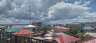
Bartica is a town located on the west bank of the Essequibo River in Cuyuni-Mazaruni, at the confluence of the Cuyuni and Mazaruni Rivers with the Essequibo River in Guyana. It is the regional capital of Cuyuni-Mazaruni.

Barima-Waini is a region of Guyana and is located in the northwest of the country. Barima-Waini has three sub-regions: Mabaruma, Matakai, and Moruca.
Matthews Ridge is a small village within the Barima-Waini administrative region of Guyana. The village name comes from the name of a public official, Matthew Young, as well as the ridges in the area. The village is divided into three sections, Heaven's Hill, Hell Hill and the valley.

The Mazaruni River is a tributary of the Essequibo River in northern Guyana. Its source is in the remote western forests of the Pakaraima Mountains and its confluence with the Cuyuni River is near Bartica. As it descends from the Guiana Highlands the river runs south-east, past Issano, then northward to Bartica. The river is a source of alluvial gold.
Hosororo is a community in the Barima-Waini region of northern Guyana, on the west bank of the Aruka River, 10 km (6.2 mi) from the river's mouth, and three miles from Mabaruma.
Kartabo is a village in the Cuyuni-Mazaruni Region of Guyana.

Kamarang is an Amerindian village, standing at the confluence of the Kamarang River and Mazaruni River, in the Cuyuni-Mazaruni Region of Guyana.

Mahdia is a town in Guyana, located near the centre of the country at an altitude of 415 m (1,362 ft).
Campbelltown is an Amerindian village in the Potaro-Siparuni Region of Guyana, north of Mahdia. The village has been named after Stephen Campbell, the first Amerindian member of Parliament in Guyana.
Princeville is an Amerindian community in the Potaro-Siparuni Region of Guyana.
Kurupung is a mining community in the Cuyuni-Mazaruni Region of Guyana, near the Pakaraima Mountains.
St. Monica Karawab is a village in the Pomeroon-Supenaam region of Guyana. The village is an Amerindian village.
The Kako River is a river in the Cuyuni-Mazaruni region of Guyana and one of the largest tributaries of the Mazaruni River.

Mainstay Lake is a lake in the Pomeroon-Supenaam Region of Guyana, near the Atlantic coast, northwest of the mouth of the Essequibo River, 12 mi (19 km) north of Adventure. There is a 0.5 mi (0.80 km) stretch of white sand at the edge of the lake.
Mining in Guyana is a significant contributor to the economy owing to sizable reserves of bauxite, gold, and diamonds. Much of these resources are found in Guyana's Hilly Sand and Clay belt, a region that makes up 20% of the country.
Fairview (Kurupukari) is an indigenous settlement on the Essequibo River, in the Upper Demerara-Berbice region of Guyana. It is the entry point to the Iwokrama Forest. Former president David A. Granger once referred to Iwokrama as the "green heart of Guyana."
Rewa is an Amerindian village in the Upper Takutu-Upper Essequibo region of Guyana.
Isseneru is an Amerindian settlement in the Cuyuni-Mazaruni region of Guyana, approximately 15–20 miles west of Kurupung.
Paruima is an indigenous village of Pemon Amerindians in the Cuyuni-Mazaruni Region of Guyana. The village was founded as a mission of the Seventh-day Adventist Church. It is the only Pemon speaking community in Guyana.
Agatash is a village in the Cuyuni-Mazaruni Region of Guyana. It is located about 3 miles (4.8 km) south of Bartica along the Essequibo River opposite Sloth Island.
