
Barima-Waini is a region of Guyana. Venezuela claims the territory as part of Guayana Esequiba.

Mabaruma is the administrative centre for Region One (Barima-Waini) of Guyana. It is located close to the Aruka River on a narrow plateau above the surrounding rainforest at an elevation of 13 metres.
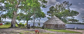
Kamwatta Hill is a community in the Barima-Waini Region, in northern Guyana. Kamwatta is an Amerindian village inhabited by Warao and Arawak people.

The Warao are an indigenous Amerindian people inhabiting northeastern Venezuela, Trinidad and Tobago, Guyana, and Suriname. Alternate common spellings of Warao are Waroa, Guarauno, Guarao, and Warrau. The term Warao translates as "the boat people," after the Warao's lifelong and intimate connection to the water. Most Warao inhabit Venezuela's Orinoco Delta region, with smaller numbers in neighbouring Guyana, Trinidad and Tobago, and Suriname. With a population of 49,271 people in Venezuela during the 2011 census, they were the second largest indigenous group after the Wayuu people. They speak an agglutinative language, Warao.

Mahdia is the capital of the Potaro-Siparuni region of Guyana, located near the centre of the country at an altitude of 415 metres (1,362 ft).

Guyana, officially the Co‑operative Republic of Guyana, is a country on the northern mainland of South America. Guyana is an indigenous word which means "Land of Many Waters". The capital city is Georgetown. Guyana is bordered by the Atlantic Ocean to the north, Brazil to the south and southwest, Venezuela to the west, and Suriname to the east. With 215,000 km2 (83,000 sq mi), Guyana is the third-smallest sovereign state by area in mainland South America after Uruguay and Suriname, and is the second-least populous sovereign state in South America after Suriname; it is also one of the least densely populated countries on Earth. It has a wide variety of natural habitats and very high biodiversity.
The people of Guyana, or Guyanese, come from a wide array of backgrounds and cultures including aboriginal natives, also known as Amerindians, and those who are descended from the slaves and contract workers who worked in the sugar industry of the Caribbean for various European interests, mostly of Indian origins. Demographics as of 2012 are East Indian 39.8%, Afro-Guyanese 30.1%, mixed race 19.9%, Amerindian 10.5%, other 1.5%.
The Amacuro River is a river in South America. It forms part of the northern section of the international boundary between Venezuela and Guyana. It is part of the Orinoco River basin.

Indigenous peoples in Guyana, Native Guyanese, or Amerindian Guyanese are Guyanese people who are of indigenous ancestry. They comprise approximately 9.16% of Guyana's population. Amerindians are credited with the invention of the canoe, as well as Cassava-based dishes and Guyanese pepperpot, the national dish of Guyana. Amerindian languages have also been incorporated in the lexicon of Guyanese Creole.

Mohamed Irfaan Ali is a Guyanese politician and the president of Guyana. Ali is the first Muslim president of Guyana, along with being the second Muslim head of state in the Americas after Noor Hassanali.
Isseneru is an Amerindian settlement in the Cuyuni-Mazaruni region of Guyana, approximately 15–20 miles west of Kurupung.
St. Ignatius is an Amerindian village in the Upper Takutu-Upper Essequibo region of Guyana, near the regional capital Lethem and the border of Brazil. It was originally a mission founded by Jesuit priests to serve the Amerindians in the Rupununi savannah.
Sand Creek is a village in the Upper Takutu-Upper Essequibo Region of Guyana. Sand Creek is inhabited by Wapishana Amerindians. It is located on the Rupununi River. The main language spoken in the village is Wapishana with English as secondary language.
Capoey is a village in the Pomeroon-Supenaam Region of Guyana. The village is mainly inhabited by Lokono Amerindians. It is located on Lake Capoey, a blackwater lake, which is one of largest lakes of Essequibo.
Helena is a village in the Demerara-Mahaica Region of Guyana. Administratively the village is subdivided in Helena No.1 and Helena No.2 and is part of the Mahaica subregion.
Katoonarib is a village in the Upper Takutu-Upper Essequibo Region of Guyana. Katoonarib is inhabited by Wapishana, Macushi and other Amerindians. It is located near the Rupununi River. The main language spoken in the village is Wapishana with English as secondary language.
Vriesland is a village in the Essequibo Islands-West Demerara Region of Guyana. It is located on the west bank of the Demerara River.
Agatash is a village in the Cuyuni-Mazaruni Region of Guyana. It is located about 3 miles (4.8 km) south of Bartica along the Essequibo River opposite Sloth Island.
Sawariwau is a village in the Upper Takutu-Upper Essequibo Region of Guyana. Sawariwau is inhabited by Wapishana Amerindians. It is located about 70 miles (110 km) south of Lethem in the Rupununi savannah. The main language spoken in the village is Wapishana.
Maruranau is an indigenous village of Wapishana Amerindians in the Upper Takutu-Upper Essequibo Region of Guyana. It is located in the Rupununi savannah near the Kwitaro River on the edge of the Kanuku Mountains. A minority of Taruma also inhabit the village.
