Campbelltown, Guyana

Last updated
Campbelltown
Village
Guyana location map.svg
Red pog.svg
Campbelltown
Location in Guyana
Coordinates: 5°17′22″N59°09′21″W / 5.2895°N 59.1557°W / 5.2895; -59.1557 Coordinates: 5°17′22″N59°09′21″W / 5.2895°N 59.1557°W / 5.2895; -59.1557
Country Flag of Guyana.svg Guyana
Region Potaro-Siparuni
Government
  ToshaoMarbell Thomas (2018) [1]
Population
 (2012) [2]
  Totalc.300

Campbelltown is an Amerindian village in the Potaro-Siparuni Region of Guyana, north of Mahdia. The village has been named after Stephen Campbell, the first Amerindian member of Parliament in Guyana. [3]

Overview

Campbelltown is managed by the village Captain (Toshao), a Vice Captain and five councillors. This community has a population of about 300 persons, [2] being Amerindians and mixed people of part Amerindian descent. Most residents of this village are members of the Patamona tribe, but the village has become mixed with Arawak and Carib tribes. There has been some degree of integration between the Amerindians and Afro-Guyanese and the Brazilian miners. [2] The village has merged with neighbouring Mahdia, [2] and is not listed separately on the census. [4] Even though Mahdia has a town status, Campbelltown is still governed by the Toshao. [5]

Farming is the main economic activity and subsistence farming is practised by the residents on farmlands miles away from the village. [2] Some of the Amerindian men are employed as guides, gold miners, [2] labourers and drivers. Some women from this area work at the Regional Office, the schools and some of the stores in the Madhia community. [6] Most of the other residents hunt, fish and farm for their livelihood. The women reported that men live in the mining camps. This has resulted in several families being headed by women.

There are no industries, shops or businesses in this community. There is a community ground and an Amerindian hostel which provides free accommodation for Amerindian miners and families who are in-transit.

The community has a well which is powered by a windpump. Residents usually depend on rainwater and creek water whenever the well malfunctions. Campbelltown has no other utility service. This community is accessible by road from Mahdia and by trail linked to the Bartica/Potaro road.

Related Research Articles

<span class="mw-page-title-main">Mabaruma</span> Town and regional capital in Barima-Waini, Guyana

Mabaruma is the administrative centre for Region One (Barima-Waini) of Guyana. It is located close to the Aruka River on a narrow plateau above the surrounding rainforest at an elevation of 13 metres.

Kartabo is a village in the Cuyuni-Mazaruni Region of Guyana.

Orinduik is a diamond-mining community in the Potaro-Siparuni region of Guyana near the border with Brazil.

<span class="mw-page-title-main">Mahdia, Guyana</span> Town and regional capital in Potaro-Siparuni, Guyana

Mahdia is the capital of the Potaro-Siparuni region of Guyana, located near the centre of the country at an altitude of 415 metres (1,362 ft).

<span class="mw-page-title-main">Kabakaburi</span> Amerindian Village in Pomeroon-Supenaam, Guyana

Kabakaburi is an Amerindian village in the Pomeroon-Supenaam Region of Guyana on the Pomeroon River, 56 km (35 mi) from its mouth. The village was founded in 1845 by William Henry Brett on the location where Fort Durban used to be.

Princeville is an Amerindian community in the Potaro-Siparuni Region of Guyana.

Tumatumari is a community in the Potaro-Siparuni Region of Guyana, located some 15 km upstream of the confluence of the Potaro and Essequibo Rivers.

Tumatumari Landing Village in Potaro-Siparuni, Guyana

Tumatumari Landing is a small community in the Potaro-Siparuni Region of Guyana, across the Potaro River from Tumatumari, near the Konawaruk Road, and to the east of El Paso.

El Paso is a village in the Potaro-Siparuni Region of Guyana. The village is on the Potaro River to the west of Tumatumari Falls, and Tumatumari Landing.

Micobie is a village in Potaro-Siparuni, Guyana, on the right bank of the Potaro River near Tumatumari.

<span class="mw-page-title-main">Paramakatoi</span> Place in Potaro-Siparuni, Guyana

Paramakatoi is an Amerindian community in the Potaro-Siparuni Region of Guyana, located in the Pacaraima Mountains. With an altitude of 970 metres (3,180 ft), it is 18 kilometres (11 mi) east of Kurukabaru.

St. Monica Karawab is a village in the Pomeroon-Supenaam region of Guyana. The village is an Amerindian village.

The Kako River is a river in the Cuyuni-Mazaruni region of Guyana and one of the largest tributaries of the Mazaruni River.

St. Cuthbert's Mission is an Amerindian village on the Mahaica River in the Demerara-Mahaica region of Guyana. It comprises approximately 200 households. St. Cuthbert's is regarded by many people in Guyana as the "cultural capital" for Amerindians.

<span class="mw-page-title-main">Denham Suspension Bridge</span> Bridge

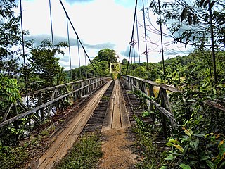
The Denham Suspension Bridge, also known as the Garraway Stream Bridge is a footbridge in Guyana linking Mahdia to Bartica. This suspension bridge was constructed over the Potaro River in an area known as Garraway Stream by a Scottish civil engineer and general contractor, John Aldi, on 6 November 1933.

Issano is a village of Cuyuni-Mazaruni, Guyana. It's located along the Mazaruni River, and is a hub for mining.

St. Ignatius is an Amerindian village in the Upper Takutu-Upper Essequibo region of Guyana, near the regional capital Lethem and the border of Brazil. It was originally a mission founded by Jesuit priests to serve the Amerindians in the Rupununi savannah.

<span class="mw-page-title-main">Yvonne Fredericks-Pearson</span> Guyanese politician

Yvonne Fredericks-Pearson is a Guyanese politician. She has been a member of the National Assembly since 2015. She served as Toshao of Mainstay/Whyaka from 1994 to 2012.

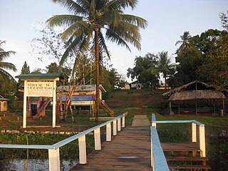
Whitewater is a village in the Barima-Waini Region of Guyana. Whitewater is located close to the border with Venezuela and is inhabited by Warao Amerindians.

<span class="mw-page-title-main">Kato, Guyana</span> Village in Potaro-Siparuni, Guyana

Kato is an indigenous village in the Potaro-Siparuni Region of Guyana. The village is mainly inhabited by Patamona people. The village is located in the Pacaraima Mountains.

References

  1. "New Campbelltown toshao banks on experience to get the job done". Stabroek News. Retrieved 9 September 2020.
  2. 1 2 3 4 5 6 "Campbelltown" . Retrieved 17 August 2020.
  3. "Indigenous Peoples of the A-B-C countries of South America". Guyana Chronicle. Retrieved 9 September 2020.
  4. "2012 Population by Village". Statistics Guyana. Retrieved 17 August 2020.
  5. "Mahdia declared Guyana's 10th town". Stabroek News. Retrieved 17 August 2020.
  6. "Campbelltown Revisited". Stabroek News. Retrieved 17 August 2020.