The transport sector comprises the physical infrastructure, docks and vehicle, terminals, fleets, ancillary equipment and service delivery of all the various modes of transport operating in Guyana. The transport services, transport agencies providing these services, the organizations and people who plan, build, maintain, and operate the system, and the policies that mold its development.

Demerara is a historical region in the Guianas, on the north coast of South America, now part of the country of Guyana. It was a Dutch colony until 1815 and a county of British Guiana from 1838 to 1966. It was located around the lower course of the Demerara River, and its main settlement was Georgetown.

Essequibo Islands-West Demerara is a region of Guyana.
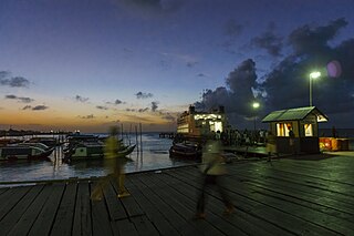
Parika is a port village located in the Essequibo Islands-West Demerara region of Guyana. Its ferry service is operated by the Ministry of Transportation, to and from the Essequibo Islands and West Demerara area. It is a hub for land transport, since it is a route stop for local taxis commonly called "buses."

Charity is a small township in Guyana, located in the Pomeroon-Supenaam Region No.2, which is part of the Essequibo County.
Afro-Guyanese are generally descended from the enslaved people brought to Guyana from the coast of West Africa to work on sugar plantations during the era of the Atlantic slave trade. Coming from a wide array of backgrounds and enduring conditions that severely constrained their ability to preserve their respective cultural traditions contributed to the adoption of Christianity and the values of British colonists.
The Railways of Guyana comprised two public railways, the Demerara-Berbice Railway and the Demerara-Essequibo railway. There are also several industrial railways mainly for the bauxite industry. The Demerara-Berbice Railway is the oldest in South America. None of the railways are in operation in the 21st century.
Adventure is a village located in the Pomeroon-Supenaam Region of Guyana, on the Atlantic coast, at sea level, one mile south of Onderneeming.
Met-en-Meerzorg is a village located on the West Coast of Demerara in the region of Essequibo Islands-West Demerara in Guyana. The village was named after the sugar plantation Met en Meerzorg.
Zeeburg is a village located on the West Coast of Demerara in Guyana, South America. The village, in the administrative region Essequibo Islands-West Demerara was named by the Dutch during their occupation of Guyana.
Leonora is a village in Essequibo Islands-West Demerara, one of Guyana's 10 regions. Its subdivisions are Pasture, Sea Field, Para Field, Groenveldt and Sea Spray. The neighboring villages are Anna Catherina and Uitvlugt. Leonora encompasses an area of about 13 square kilometres (5 sq mi), once part of the Parish of St. Luke. It stretches from Edinburgh in the east to Stewartville in the west, and from the Atlantic Ocean in the north, to the south as far as the West Demerara Water Conservancy.

Rockstone is a village on the right bank of the Essequibo River in the Upper Demerara-Berbice Region of Guyana, altitude 6 metres. Rockstone is approximately 26 km west of Linden and is linked by road.
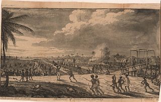
The Demerara rebellion of 1823 was an uprising involving more than 10,000 enslaved people that took place in the colony of Demerara-Essequibo (Guyana). The rebellion, which began on August 18, 1823, and lasted for two days, was led by slaves with the highest status. In part they were reacting to poor treatment and a desire for freedom; in addition, there was a widespread, mistaken belief that Parliament had passed a law for emancipation, but it was being withheld by the colonial rulers. Instigated chiefly by Jack Gladstone, a slave at "Success" plantation, the rebellion also involved his father, Quamina, and other senior members of their church group. Its English pastor, John Smith, was implicated.
Uitvlugt is a village in the Essequibo Islands-West Demerara region of Guyana. On the coastal public road on the west bank of the Demerara River, it lies immediately to the west of Stewartville and to the south of Zeeburg, about 20 minutes by road from Vreed-en-Hoop.
Den Amstel is a village in Guyana's Essequibo Islands-West Demerara region. It lies on the Atlantic coast, approximately 13 kilometres (8.1 mi) west-north-west of the capital, Georgetown. The village has a population of 938 people as of 2012, who are predominantly Afro-Guyanese.
Goed Fortuin is a village located in the Essequibo Islands-West Demerara region of Guyana. The village started as a sugar plantation in the early 1800s.
Laurens Storm van 's Gravesande was a Dutch governor of the colonies of Essequibo and Demerara from 1743 to 1772. He turned Demerara in a successful plantation colony, and the borders of Guyana are mainly based on his expeditions into the interior. He is also noted for his treatment of the Amerindians.

Squatting in Guyana is the occupation of unused land or derelict buildings without the permission of the owner. Squatting has been used as a means to find housing by people displaced by conflict in the 1960s and by internal migrants from the 1980s onwards. In 2015, there were estimated to be over 100,000 squatters across the country. The government announced the National Squatter Regularisation Commission (NSRC) and the State Land Resettlement Commission in 2020, in the following year it allied with UN-Habitat to create the Guyana Strategy for Informal Settlements Upgrading and Prevention (GSISUP) which aims to regularize all informal settlements by 2030.
Vriesland is a village in the Essequibo Islands-West Demerara Region of Guyana. It is located on the west bank of the Demerara River.
Windsor Forest is a village in the Essequibo Islands-West Demerara Region of Guyana. It is located along the Atlantic Ocean coast. It was the first Chinese settlement in Guyana, however few Chinese remain.
