
Barima-Waini is a region of Guyana. Venezuela claims the territory as part of Guayana Esequiba.

The Tiriyó are an Amerindian ethnic group native to parts of northern Brazil, Suriname, and Guyana. In 2014, there were approximately 3,640 Tiriyó in the three countries. They live in several major villages and a number of minor villages in the border zone between Brazil and Suriname. They speak the Tiriyó language, a member of the Cariban language family and refer to themselves as tarëno, etymologically 'people from here' or 'local people'.

The Rupununi savannah is a savanna plain in Guyana, in the Upper Takutu-Upper Essequibo region. It is part of the Guianan savanna ecoregion of the tropical and subtropical grasslands, savannas, and shrublands biome.
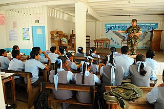
Santa Rosa is a community in the Barima-Waini region of northern Guyana. Santa Rosa mission was established in 1840, and is one of the earliest Catholic Missions in Guyana. The village is part of the North West Amerindian District.
Assakata or Asakata is a village in Barima-Waini region, in the north of Guyana. Assakata is an Amerindian village inhabited by Warao and Arawak people, located in the swamps and marshes between the Barima and Pomeroon River.
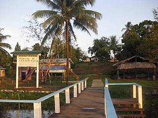
Hosororo is a community in the Barima-Waini region of northern Guyana, on the west bank of the Aruka River, 10 km (6.2 mi) from the river's mouth, and three miles from Mabaruma.

The Warao are an indigenous Amerindian people inhabiting northeastern Venezuela, Trinidad and Tobago, Guyana, and Suriname. Alternate common spellings of Warao are Waroa, Guarauno, Guarao, and Warrau. The term Warao translates as "the boat people," after the Warao's lifelong and intimate connection to the water. Most Warao inhabit Venezuela's Orinoco Delta region, with smaller numbers in neighbouring Guyana, Trinidad and Tobago, and Suriname. With a population of 49,271 people in Venezuela during the 2011 census, they were the second largest indigenous group after the Wayuu people. They speak an agglutinative language, Warao.
Achiwib is a village in the Upper Takutu-Upper Essequibo Region of Guyana. Achiwib is an Amerindian community that borders Brazil, the main language spoken in the village is Wapishana language.
Imbaimadai is a community in the Cuyuni-Mazaruni Region of Guyana.

Annai is an Amerindian village in the Upper Takutu-Upper Essequibo Region of Guyana.
Kabakaburi is an Amerindian village in the Pomeroon-Supenaam Region of Guyana on the Pomeroon River, 56 km (35 mi) from its mouth. The village was founded in 1845 by William Henry Brett on the location where Fort Durban used to be.
The Arawak village of Wakapau is located in the Pomeroon-Supenaam Region of Guyana, on the Wakapau River, a tributary on the west bank of the Pomeroon River, 3 kilometres (1.9 mi) from its mouth. The name originates from the Lokono word ‘Wakokwãn’, which means pigeon. The village is composed of twenty inhabited islands. Some of the islands only contain a single family.
Tumatumari is a community in the Potaro-Siparuni Region of Guyana, located some 15 km upstream of the confluence of the Potaro and Essequibo Rivers.
Aishalton is an Amerindian village that is situated in the Rupununi savannah of southern Guyana, in the Upper Takutu-Upper Essequibo Region of the country.
Koriabo is a community in the Barima-Waini region of Guyana, standing at an altitude of 36 metres. Barima and Koriba form an Amerindian community which is mainly inhabited by Warao people with a minority of Arawak and Kalina people.
St. Monica Karawab is a village in the Pomeroon-Supenaam region of Guyana. The village is an Amerindian village.

Guyana, officially the Co‑operative Republic of Guyana, is a country on the northern mainland of South America. Guyana is an indigenous word which means "Land of Many Waters". The capital city is Georgetown. Guyana is bordered by the Atlantic Ocean to the north, Brazil to the south and southwest, Venezuela to the west, and Suriname to the east. With 215,000 km2 (83,000 sq mi), Guyana is the third-smallest sovereign state by area in mainland South America after Uruguay and Suriname, and is the second-least populous sovereign state in South America after Suriname; it is also one of the least densely populated countries on Earth. It has a wide variety of natural habitats and very high biodiversity.
The Kanashen Community Owned Conservation (COCA) is Guyana's first community-owned area that is legally protected; it is primarily inhabited by the Wai-Wai indigenous group.
Whitewater is a village in the Barima-Waini Region of Guyana. Whitewater is located close to the border with Venezuela and is inhabited by Warao Amerindians.

Santa Mission is a village in the Essequibo Islands-West Demerara Region of Guyana. Santa Mission is mainly inhabited by Lokono Amerindians. The village is located on the Kamuni Creek, a tributary of the Demerara River. The village of Hopetown, an early Chinese settlement, is located about 15 kilometres (9.3 mi) from Santa Mission.
