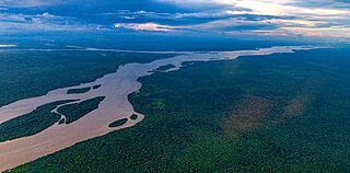
The Essequibo River is the largest river in Guyana, and the largest river between the Orinoco and Amazon. Rising in the Acarai Mountains near the Brazil–Guyana border, the Essequibo flows to the north for 1,014 kilometres (630 mi) through forest and savanna into the Atlantic Ocean. With a total drainage basin of 151,000 square kilometres (58,000 sq mi) and an average discharge of 4,531 cubic metres per second (160,000 cu ft/s).
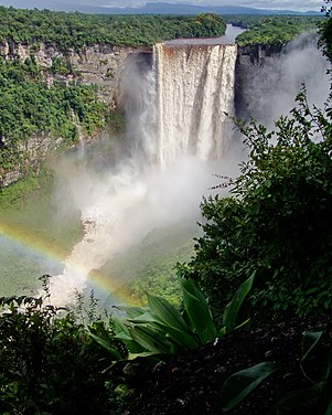
Kaieteur Falls is the world's largest single drop waterfall by the volume of water flowing over it. Located on the Potaro River in the Kaieteur National Park, it sits in a section of the Amazon rainforest included in the Potaro-Siparuni region of Guyana. It is 226 metres (741 ft) high when measured from its plunge over a sandstone and conglomerate cliff to the first break. It then flows over a series of steep cascades that, when included in the measurements, bring the total height to 251 metres (822 ft). While many falls have greater height, few have the combination of height and water volume, and Kaieteur is among the most powerful waterfalls in the world with an average flow rate of 663 cubic metres per second.

Cuyuni-Mazaruni is a region of Guyana. Venezuela claims the territory as part of Guayana Esequiba.
Potaro-Siparuni is a region of Guyana. Venezuela claims the territory as part of Guayana Esequiba.

Kaieteur National Park is a national park located in the Potaro-Siparuni Region of Guyana. The Park's boundaries and purpose are defined in the Kaieteur National Park Act, and was created to preserve the natural scenery, and its fauna and flora. The Act is administered by the Kaieteur National Park Commission.

The Potaro River is a river in Guyana that runs from Mount Ayanganna area of the Pakaraima Mountains for approximately 225 km (140 mi) before flowing into the Essequibo River, Guyana's largest river. The renown Kaieteur Falls is on the Potaro.

Orinduik is a diamond-mining community in the Potaro-Siparuni region of Guyana near the border with Brazil.
The Konawaruk River is a river in Potaro-Siparuni, Guyana. About 60 miles long, it is a tributary of the Essequibo River, joining it just south of the Potaro River mouth at 5°18′N58°55′W.

Mahdia is the capital of the Potaro-Siparuni region of Guyana, located near the centre of the country at an altitude of 415 metres (1,362 ft).
Campbelltown is an Amerindian village in the Potaro-Siparuni Region of Guyana, north of Mahdia. The village has been named after Stephen Campbell, the first Amerindian member of Parliament in Guyana.
Princeville is an Amerindian community in the Potaro-Siparuni Region of Guyana.
Tumatumari is a community in the Potaro-Siparuni Region of Guyana, located some 15 km upstream of the confluence of the Potaro and Essequibo Rivers.
El Paso is a village in the Potaro-Siparuni Region of Guyana. The village is on the Potaro River to the west of Tumatumari Falls, and Tumatumari Landing.
Micobie is a village in Potaro-Siparuni, Guyana, on the right bank of the Potaro River near Tumatumari.
Amaila Falls is located on the Kuribrong River, a tributary of the Potaro River in west central Guyana.
Vreed en Hoop is a village at the mouth of the Demerara River on its left bank, in the Essequibo Islands-West Demerara region of Guyana, located at sea level. It is the location of the Regional Democratic Council office making it the administrative center for the region. There is also a police station, magistrate's court and post office.
The Kuribrong River is a river of Guyana, a tributary of the Potaro River 2 miles north east of Potaro Landing.
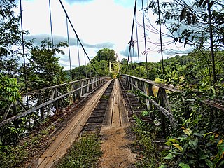
The Denham Suspension Bridge, also known as the Garraway Stream Bridge is a footbridge in Guyana linking Mahdia to Bartica. This suspension bridge was constructed over the Potaro River in an area known as Garraway Stream by a Scottish civil engineer and general contractor, John Aldi, on 6 November 1933.
Issano is a village of Cuyuni-Mazaruni, Guyana. It's located along the Mazaruni River, and is a hub for mining.

