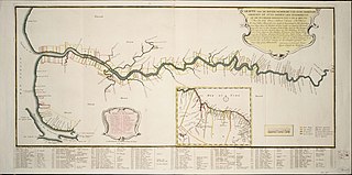
Demerara is a historical region in the Guianas, on the north coast of South America, now part of the country of Guyana. It was a colony of the Dutch West India Company between 1745 and 1792 and a colony of the Dutch state from 1792 until 1815. It was merged with Essequibo in 1812 by the British who took control. It formally became a British colony in 1815 until Demerara-Essequibo was merged with Berbice to form the colony of British Guiana in 1831. In 1838, it became a county of British Guiana until 1958. In 1966, British Guiana gained independence as Guyana and in 1970 it became a republic as the Co-operative Republic of Guyana. It was located around the lower course of the Demerara River, and its main settlement was Georgetown.

New Amsterdam is the regional capital of East Berbice-Corentyne, Guyana and one of the country's largest towns. It is 100 kilometres (62 mi) from the capital, Georgetown and located on the eastern bank of the Berbice River, 6 km (4 mi) upriver from its mouth at the Atlantic Ocean, and immediately south of the Canje River. New Amsterdam's population is 17,329 inhabitants as of 2012.

The Berbice River, located in eastern Guyana, is one of the country's major rivers. It rises in the highlands of the Rupununi region and flows northward for 595 kilometres (370 mi) through dense forests to the coastal plain. The river's tidal limit is between 160 and 320 km (99–199 mi) from the sea.

Berbice is a region along the Berbice River in Guyana, which was between 1627 and 1792 a colony of the Dutch West India Company and between 1792 and 1815 a colony of the Dutch state. After having been ceded to the United Kingdom of Great Britain and Ireland in the latter year, it was merged with Demerara-Essequibo to form the colony of British Guiana in 1831. It became a county of British Guiana in 1838 till 1958. In 1966, British Guiana gained independence as Guyana and in 1970 it became a republic as the Co-operative Republic of Guyana.
Rosignol is a village on the west bank of the Berbice River in Mahaica-Berbice, Guyana.
Ituni is a village in the interior of Guyana, at an altitude of 100 metres (331 feet). The area grew as a result of bauxite mining in the area.
Afro-Guyanese are generally descended from the enslaved people brought to Guyana from the coast of West Africa to work on sugar plantations during the era of the Atlantic slave trade. Coming from a wide array of backgrounds and enduring conditions that severely constrained their ability to preserve their respective cultural traditions contributed to the adoption of Christianity and the values of British colonists.
Baracara was founded as a maroon community in the East Berbice-Corentyne Region of Guyana, located on the Canje River. The community has also been called New Ground Village or Wel te Vreeden. Baracara is 20 miles west of Corriverton and just north of the Torani Canal's connection to the Canje River.
Crabwood Creek is a small community on the Corentyne River in the East Berbice–Corentyne region of Guyana. The population of 4,459 people as of 2012 and primarily Indo-Guyanese.
Weldaad is a community in the Mahaica-Berbice Region of Guyana on the Atlantic Ocean coast. It contains the areas' post office and a police station. The origin of the names comes from the plantation Weldaad, which was founded when the areas that make up Guyana were Dutch colonies.
The Railways of Guyana comprised two public railways, the Demerara-Berbice Railway and the Demerara-Essequibo Railway. There are also several industrial railways mainly for the bauxite industry. The Demerara-Berbice Railway is the oldest in South America. None of the railways are in operation in the 21st century.

Mahaicony is a community that is made up of several villages in East Coast Demerara, Mahaica-Berbice, Guyana. Mahaicony's physical boundaries on the coast is from De Hoop village in the west to Calcutta village in the east.
Belladrum is a small community in the Mahaica-Berbice Region of Guyana, on the Atlantic coast, about 15 kilometres (9 mi) east of Mahaicony.
Port Mourant is a town on the Atlantic coast in East Berbice-Corentyne, Guyana. It is the birthplace of the late president Cheddi Jagan as well as many of Guyana's most famous cricketers. Port Mourant was originally a sugar estate. Many residents are self-employed, but the sugar industry continues to be a source of employment.

Rockstone is a village on the right bank of the Essequibo River in the Upper Demerara-Berbice Region of Guyana, altitude 6 metres. Rockstone is approximately 26 km west of Linden and is linked by road.
Catherinas Lust is an estate located approximately 13.8 km from the town of Fort Wellington in the Mahaica-Berbice region of Guyana in South America. It is listed as a village in the 2012 census.
Albion is a village in East Berbice-Corentyne, Guyana.
Moraikobai is an Amerindian village located in the Mahaica-Berbice of Guyana, South America.
Helena is a village in the Demerara-Mahaica Region of Guyana. Administratively the village is subdivided in Helena No.1 and Helena No.2 and is part of the Mahaica subregion.
Kingston is a former village in Demerara. In 1837, it became a ward of Georgetown. The ward is located along the Atlantic Ocean coast. Kingston is home to many landmarks and historic buildings.
