
Cuyuni-Mazaruni is a region of Guyana. Venezuela claims the territory as part of Guayana Esequiba.
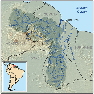
The Mazaruni River is a tributary of the Essequibo River in northern Guyana. Its source is in the remote western forests of the Pakaraima Mountains and its confluence with the Cuyuni River is near Bartica. As it descends from the Guiana Highlands the river runs south-east, past Issano, then northward to Bartica. The river is a source of alluvial gold.
Ituni is a village in the interior of Guyana, at an altitude of 100 metres (331 feet). The area grew as a result of bauxite mining in the area.
Imbaimadai is a community in the Cuyuni-Mazaruni Region of Guyana.

Annai is an Amerindian village in the Upper Takutu-Upper Essequibo Region of Guyana.
Baracara was founded as a maroon community in the East Berbice-Corentyne Region of Guyana, located on the Canje River. The community has also been called New Ground Village or Wel te Vreeden. Baracara is 20 miles west of Corriverton and just north of the Torani Canal's connection to the Canje River.

Mahdia is the capital of the Potaro-Siparuni region of Guyana, located near the centre of the country at an altitude of 415 metres (1,362 ft).
Kabakaburi is an Amerindian village in the Pomeroon-Supenaam Region of Guyana on the Pomeroon River, 56 km (35 mi) from its mouth. The village was founded in 1845 by William Henry Brett on the location where Fort Durban used to be.
Campbelltown is an Amerindian village in the Potaro-Siparuni Region of Guyana, north of Mahdia. The village has been named after Stephen Campbell, the first Amerindian member of Parliament in Guyana.
Tumatumari is a community in the Potaro-Siparuni Region of Guyana, located some 15 km upstream of the confluence of the Potaro and Essequibo Rivers.

Tumatumari Landing is a small community in the Potaro-Siparuni Region of Guyana, across the Potaro River from Tumatumari, near the Konawaruk Road, and to the east of El Paso.
Micobie is a village in Potaro-Siparuni, Guyana, on the right bank of the Potaro River near Tumatumari.

The Patamona are an Amerindian people native to the Pakaraima Mountains of Guyana and northern Brazil. They speak a Cariban language, Kapóng, and have often been referred to interchangeably as Akawaio or Ingariko. Patamona are considered a sub-group of Kapon people.
The Toroparu mine is estimated to be one of the largest gold mining projects in Guyana. The mine is located in the north-west of the country in Cuyuni-Mazaruni. The mine has estimated reserves of 6 million oz of gold.
Pork-knockers are freelance Guyanese prospectors who mine for diamonds and gold in the alluvial plains of the Guyanese interior. Pork-knockers have been responsible for discovering large deposits of gold and diamonds. The name "pork-knockers" refers to their regular diet of pickled pork of wild pig that is often eaten at the end of the day. Caribbean author A. R. F. Webber suggested that the term may have originated as "pork-barrel knocker".
Issano is a village of Cuyuni-Mazaruni, Guyana. It's located along the Mazaruni River, and is a hub for mining.
Isseneru is an Amerindian settlement in the Cuyuni-Mazaruni region of Guyana, approximately 15–20 miles west of Kurupung.
Karaudarnau is an indigenous village of Wapishana Amerindians in the Upper Takutu-Upper Essequibo Region of Guyana. It is located in the Rupununi savannah on the Rupununi River.

Kato is an indigenous village in the Potaro-Siparuni Region of Guyana. The village is mainly inhabited by Patamona people. The village is located in the Pacaraima Mountains.
