
Georgetown is the capital and largest city of Guyana. It is situated in Demerara-Mahaica, region 4, on the Atlantic Ocean coast, at the mouth of the Demerara River. It is nicknamed the "Garden City of the Caribbean." It is the retail, administrative, and financial services centre of the country, and the city accounts for a large portion of Guyana's GDP. The city recorded a population of 118,363 in the 2012 census.

The prime minister of the Co-operative Republic of Guyana is an elected member of the National Assembly of Guyana who is the principal assistant and advisor to the president as well as the leader of government business in the Assembly, but is not the head of government in Guyana. The prime minister assumes the office of president if the presidency becomes vacant.

Guyana is divided into 10 Regions:

Demerara is a historical region in the Guianas, on the north coast of South America, now part of the country of Guyana. It was a Dutch colony until 1815 and a county of British Guiana from 1838 to 1966. It was located around the lower course of the Demerara River, and its main settlement was Georgetown.

Lethem is a town in Guyana, located in the Upper Takutu-Upper Essequibo region. It is the regional capital of Upper Takutu-Upper Essequibo.

Berbice is a region along the Berbice River in Guyana, which was between 1627 and 1815 a colony of the Dutch Republic. After having been ceded to the United Kingdom of Great Britain and Ireland in the latter year, it was merged with Essequibo and Demerara to form the colony of British Guiana in 1831. In 1966, British Guiana gained independence as Guyana.
The Bank of Guyana (BoG) is the central bank of Guyana. It was established in 1965 in advance of the country's independence in 1966. Dr. Gobind Ganga has been the governor of BoG since December 2014.
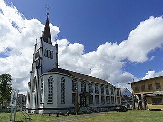
St. Andrew's Kirk is one of the oldest buildings in Georgetown, Guyana that has been continually in use for religious purposes. The Dutch Reformed congregation laid its foundations in 1811. However, due to financial difficulties it was acquired by Scottish Presbyterians and was formally opened for service on 28 February 1818.
State House located in Georgetown, is the official residence of the president of Guyana. It was previously the official residence of the governor of British Guiana before the colony gained independence and became Guyana.

Annai is an Amerindian village in the Upper Takutu-Upper Essequibo Region of Guyana.
Buxton is a village in the Demerara-Mahaica Region of Guyana, standing about midway between Georgetown and Enmore.

Mahdia is the capital of the Potaro-Siparuni region of Guyana, located near the centre of the country at an altitude of 415 metres (1,362 ft).

Guyana, officially the Co‑operative Republic of Guyana, is a country on the northern mainland of South America. Guyana is an indigenous word which means "Land of Many Waters". The capital city is Georgetown. Guyana is bordered by the Atlantic Ocean to the north, Brazil to the south and southwest, Venezuela to the west, and Suriname to the east. With 215,000 km2 (83,000 sq mi), Guyana is the third-smallest sovereign state by area in mainland South America after Uruguay and Suriname, and is the second-least populous sovereign state in South America after Suriname; it is also one of the least densely populated countries on Earth. It has a wide variety of natural habitats and very high biodiversity.
Guyana was a predecessor to the modern-day Co-operative Republic of Guyana and an independent state that existed between 1966 and 1970.
Soesdyke is a village in the Demerara-Mahaica Region, Guyana, located between the Demerara River and the East Bank Public Road. Soesdyke is located just after the village called Den Heuvel (Coverden) if you are coming from Georgetown, which is the capital of Guyana. On the other end of Soesdyke is the village Timehri about 3 miles northeast of the Cheddi Jagan International Airport.
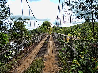
The Denham Suspension Bridge, also known as the Garraway Stream Bridge is a footbridge in Guyana linking Mahdia to Bartica. This suspension bridge was constructed over the Potaro River in an area known as Garraway Stream by a Scottish civil engineer and general contractor, John Aldi, on 6 November 1933.
The Court of Policy was a legislative body in Dutch and British Guiana until 1928. For most of its existence it formed the Combined Court together with the six Financial Representatives.
The following lists events that happened during 2020 in The Caribbean.

The COVID-19 pandemic in Guyana is part of the worldwide pandemic of coronavirus disease 2019 caused by severe acute respiratory syndrome coronavirus 2. The virus was confirmed to have reached Guyana on 11 March 2020. The first case was a woman who travelled from New York, a 52-year-old woman with underlying health conditions, including diabetes and hypertension. The woman died at the Georgetown Public Hospital.
