The transport sector comprises the physical infrastructure, docks and vehicle, terminals, fleets, ancillary equipment and service delivery of all the various modes of transport operating in Guyana. The transport services, transport agencies providing these services, the organizations and people who plan, build, maintain, and operate the system, and the policies that mold its development.

The Republic of Suriname has a number of forms of transport. Transportation emissions are an increasing part of Suriname's contributions to climate change, as part of the Nationally Determined Contributions for the Paris Agreement, Suriname has committed to emissions controls for vehicles and increased public transit investment.

Nickerie is a district of Suriname, on the north-west coast. Nickerie's capital city is Nieuw-Nickerie. Another town is Wageningen. The district borders the Atlantic Ocean to the north, the Surinamese district of Coronie to the east, the Surinamese district of Sipaliwini to the south and the region of East Berbice-Corentyne in Guyana to the west.

New Amsterdam is the regional capital of East Berbice-Corentyne, Guyana and one of the country's largest towns. It is 100 kilometres (62 mi) from the capital, Georgetown and located on the eastern bank of the Berbice River, 6 km (4 mi) upriver from its mouth at the Atlantic Ocean, and immediately south of the Canje River. New Amsterdam's population is 17,329 inhabitants as of 2012.

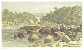
The Berbice River, located in eastern Guyana, is one of the country's major rivers. It rises in the highlands of the Rupununi region and flows northward for 595 kilometres (370 mi) through dense forests to the coastal plain. The river's tidal limit is between 160 and 320 km (99–199 mi) from the sea.
The Courantyne River, also known as Corentyne and Corantijn, is a river in northern South America in Suriname and Guyana. It is the longest river in the country and creates the border between Suriname and the East Berbice-Corentyne region of Guyana. The length of the river, including the Upper Corantyne River as it's source river, is approximately 724 km.

Nieuw Nickerie is the third largest city in Suriname with a population estimated at 12,818. It is the capital city of the Nickerie district, and the terminus of the East-West Link.

Berbice is a region along the Berbice River in Guyana, which was between 1627 and 1792 a colony of the Dutch West India Company and between 1792 and 1815 a colony of the Dutch state. After having been ceded to the United Kingdom of Great Britain and Ireland in the latter year, it was merged with Demerara-Essequibo to form the colony of British Guiana in 1831. It became a county of British Guiana in 1838 till 1958. In 1966, British Guiana gained independence as Guyana and in 1970 it became a republic as the Co-operative Republic of Guyana.

East Berbice-Corentyne is one of ten regions in Guyana covering the whole of the east of the country. It borders the Atlantic Ocean to the north, the Nickerie District and Sipaliwini District of Suriname to the east, Brazil to the south and the regions of Mahaica-Berbice, Upper Demerara-Berbice, Potaro-Siparuni and Upper Takutu-Upper Essequibo to the west.
Baracara village was founded by people of African descent in the East Berbice-Corentyne Region of Guyana, located on the Canje River. The community has also been called New Ground Village or Wel te Vreeden. Baracara is 20 miles west of Corriverton and just north of the Torani Canal's connection to the Canje River.
Crabwood Creek is a small community on the Corentyne River in the East Berbice–Corentyne region of Guyana. The population of 4,459 people as of 2012 and primarily Indo-Guyanese.
The Berbice Rebellion was a slave rebellion in Guyana that began on 23 February 1763 and lasted to December, with leaders including Coffij. The first major slave revolt in South America, it is seen as a major event in Guyana's anti-colonial struggles, and when Guyana became a republic in 1970 the state declared 23 February as a day to commemorate the start of the Berbice slave revolt.
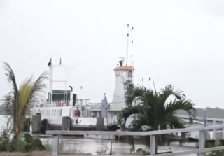
Moleson Creek is a community on the Corentyne River in the East Berbice-Corentyne region of Guyana, and home to the Guyana-Suriname ferry stelling. It is north of Orealla Mission, 10 km (6.2 mi) south of Corriverton, and approximately 90 km (56 mi) from New Amsterdam.

Guyana officially the Co-operative Republic of Guyana, is a country on the northern coast of South America, part of the historic mainland British West Indies. Georgetown is the capital of Guyana and is also the country's largest city. Guyana is bordered by the Atlantic Ocean to the north, Brazil to the south and southwest, Venezuela to the west, and Suriname to the east. With a land area of 214,969 km2 (83,000 sq mi), Guyana is the third-smallest sovereign state by area in mainland South America after Uruguay and Suriname, and is the second-least populous sovereign state in South America after Suriname; it is also one of the least densely populated countries on Earth. The official language of the country is English, although a large part of the population is bilingual in English and the indigenous languages. It has a wide variety of natural habitats and very high biodiversity. The country also hosts a part of the Amazon rainforest, the largest tropical rainforest in the world.

Skeldon is a small town in eastern coastal Guyana, on the estuary of the Corentyne River, which forms Guyana's border with Suriname. As of 2012 it had a population of 2,275. Skeldon and Springlands have been administratively merged into Corriverton.
Westelijke Polders is a resort in Suriname, located in the Nickerie District. Its population at the 2012 census was 8,616. Its Dutch place name reflects Suriname's colonial past. Its western boundary is the Courantyne River, between Suriname and Guyana.
The (northern) East-West Link is a road in Suriname between Albina in the eastern part of the country to Nieuw Nickerie in the western part, via the capital city of Paramaribo. The southern East-West Link connects Paramaribo with Apoera via Bitagron. Construction of the road link started in the 1960s.

South Drain, also Zuiddrain, is a town in western Suriname. Since the pavement of 32 kilometres (20 mi) road section to Nieuw Nickerie, it is the final destination of the northern East-West Link. The European Union funded the reconstruction, which started in 2007, with 13.2 million euro. The section was opened on 30 April 2010. There is a jeep trail between South Drain and Apoera, connecting the Northern East-West Link with the Southern East-West Link. Contrary to earlier plans, the pavement of this road is not imminent.

There are several named highways in the country of Suriname.
