
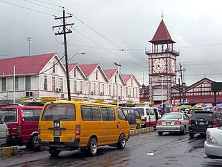
Georgetown is the capital and largest city of Guyana. It is situated in Demerara-Mahaica, region 4, on the Atlantic Ocean coast, at the mouth of the Demerara River. It is nicknamed the "Garden City of the Caribbean." It is the retail, administrative, and financial services centre of the country, and the city accounts for a large portion of Guyana's GDP. The city recorded a population of 118,363 in the 2012 census.
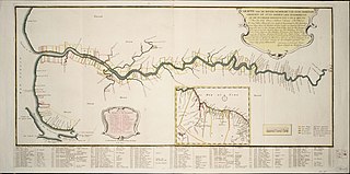
Demerara is a historical region in the Guianas, on the north coast of South America, now part of the country of Guyana. It was a colony of the Dutch West India Company between 1745 and 1792 and a colony of the Dutch state from 1792 until 1815. It was merged with Essequibo in 1812 by the British who took control. It formally became a British colony in 1815 until Demerara-Essequibo was merged with Berbice to form the colony of British Guiana in 1831. In 1838, it became a county of British Guiana until 1958. In 1966, British Guiana gained independence as Guyana and in 1970 it became a republic as the Co-operative Republic of Guyana. It was located around the lower course of the Demerara River, and its main settlement was Georgetown.
Demerara-Mahaica is a region of Guyana, bordering the Atlantic Ocean to the north, the region of Mahaica-Berbice to the east, the region of Upper Demerara-Berbice to the south and the region of Essequibo Islands-West Demerara to the west.

Afro-Guyanese, also known as Black Guyanese, are generally descended from the enslaved African people brought to Guyana from the coast of West Africa to work on sugar plantations during the era of the Atlantic slave trade. Coming from a wide array of backgrounds and enduring conditions that severely constrained their ability to preserve their respective cultural traditions contributed to the adoption of Christianity and the values of British colonists.
Buxton is a village in the Demerara-Mahaica Region of Guyana, standing about midway between Georgetown and Enmore.
Lusignan is a community in Demerara-Mahaica region of Guyana and approximately 16 km from the capital city Georgetown. Located on the East Coast of Demerara, it has population of 1,868 persons as of 2012 mostly Indo-Guyanese.
Met-en-Meerzorg is a village located on the West Coast of Demerara in the region of Essequibo Islands-West Demerara in Guyana. The village was named after the sugar plantation Met en Meerzorg.
Beterverwagting, also Betterverwagting or abbreviated to B.V., is a village in Guyana, on the East Coast of the Demerara River.
Zeeburg is a village located on the West Coast of Demerara in Guyana, South America. Zeeburg is 30.6km far from the capital of Guyana. The village, in the administrative region Essequibo Islands-West Demerara was named by the Dutch during their occupation of Guyana.
The Lusignan massacre refers to the murder of eleven residents of Lusignan, East Coast Demerara, Guyana, on 26 January 2008. The victims were murdered by a group led by Rondell "Fineman" Rawlins. After carrying out another massacre when they attacked the town of Bartica, Essequibo, and murdered 12 people, Rawlins and many of the other suspected gang members were later killed by Guyanese security forces. This massacre was part of a series of murders which appeared to have begun with the murder of a prison officer, Troy Williams, during the Mash Day Prison break on 23 February 2003.

Rockstone is a village on the right bank of the Essequibo River in the Upper Demerara-Berbice Region of Guyana, altitude 6 metres. Rockstone is approximately 26 km west of Linden and is linked by road.
Stewartville is a village district in Guyana on the Atlantic coast of West Demerara, just east of the mouth of the Essequibo River. There are four sections in the village: Stewartville Housing Scheme, Sarah Lodge, Stewartville Old Road and Stewartville Sea View.
Den Amstel is a village in Guyana's Essequibo Islands-West Demerara region. It lies on the Atlantic coast, approximately 13 kilometres (8.1 mi) west-north-west of the capital, Georgetown. The village has a population of 938 people as of 2012, who are predominantly Afro-Guyanese.
Mahaica is a village located in region 4 of Demerara-Mahaica in Guyana. Mahaica is often used as a subregion for the adjoining villages near the Mahaica River like Hand-en-Veldt, Good Hope, Chelsey Park, and Jonestown, which is often referred to as Mahaica or its old Dutch plantation name Voorzigtigheid.
Fort Wellington is a village located in the Mahaica-Berbice region of Guyana, serving as its regional capital.
Better Hope is a village located in the Demerara-Mahaica region of Guyana. The village has been named after the Plantation Betterhoop. It was originally a fishing village with many working on the sugar estates and nearby farms. The majority of the population is Indo-Guyanese with a minority of Afro-Guyanese.
Goed Fortuin is a village located in the Essequibo Islands-West Demerara region of Guyana. The village started as a sugar plantation in the early 1800s.
Werk-en-rust, also Werken-Rust, is a ward in Georgetown, Guyana, located along the Demerara River that feeds into the Atlantic Ocean.
Vriesland is a village in the Essequibo Islands-West Demerara Region of Guyana. It is located on the west bank of the Demerara River.
