Lethem, Guyana

Last updated
Lethem
Town and regional capital
Lethem.jpg
Lethem looking east
Guyana location map.svg
Red pog.svg
Lethem
Coordinates: 3°23′N59°48′W / 3.383°N 59.800°W / 3.383; -59.800
Country Flag of Guyana.svg Guyana
Region Upper Takutu-Upper Essequibo
Population
 (2012) [1]
  Total1,702
Time zone UTC-4

Lethem is a town in Guyana, located in the Upper Takutu-Upper Essequibo region. It is the regional capital of Upper Takutu-Upper Essequibo. [2]

Contents

It is named after Sir Gordon James Lethem, who was the Governor of British Guiana from 1941 to 12 April 1947. The city is populated by 1,702 inhabitants as of 2012. [1]

Lethem has several commercial establishments for shoes, bicycles, shirts and other items; they are especially frequented by Brazilians who usually take goods to Boa Vista, Manaus, Pacaraima and Santa Elena de Uairén.

The annual Rodeo on Easter weekend is the city's main event.

Environment and economy

Lethem, looking across the savannah to the south GuyanaRain.jpg
Lethem, looking across the savannah to the south

Lethem is part of the Guyanese Rupununi savannah where there are many vaqueiros (as spoken in the Portuguese language), or cowboys, and ranches. Local flora/fauna includes various types of cashew trees, both the fruit and nut varieties; mango trees and Coconut trees are also common. There is a cashew processing plant in St. Ignatius, one of the communities that are a part of Lethem. There is also Culvert City, and New Culvert City, and there are several retail establishments throughout the township of Lethem. The Guyanese Dollar and, the Brazilian Reals, and in some stores, even U.S. currency is now accepted by merchants.

New Guyana - Brazil bridge in Lethem LethemBridge.jpg
New Guyana - Brazil bridge in Lethem

The Guyanese and Brazilian governments opened a bridge in 2009 [3] It cost US$5 million and was paid for by Brazil. [3] over the Takatu river just north of Lethem. The bridge links northern Brazil to the roads leading to the Atlantic coastal port of Georgetown, Guyana's capital, which is about 423 kilometers (263 miles) to the north.

Water is often drawn from hand dug wells although there is a community water supply, though it is slightly salted. Bottled, filtered water is common and easily available in stores, even in 5-gallon containers.

The area's other economic activities are plant and mineral extraction, and tourism. There is a rodeo event during Easter weekend, beginning on Saturday evening, at the Triple R Ranch, with many activities, including bull riding, "wild cow milking", greased pig competition, horse racing, horse rodeo (both bareback and with saddle) for men or women, and for cowgirls, "barrel" horse races. there's also plenty food, such as chicken- or pork-on-a-stick, sun-back beef, and hot dogs. There are also games, contests and entertainment, including a rope pull between vaqueros, and then vaqueras from Georgetown, competing with area Amerindians.

Airport

Lethem has an airport (IATA Code: LTM) that connects it to the capital, Georgetown with scheduled air service most weekdays. The airport has a single, 6,194 foot (1,888 meter) paved runway with instrument markings, but no lighting. The runway is oriented at 07/25. The approach to 07 is often flown in Brazilian airspace which begins less than 1 km from the threshold. Scheduled service is provided by Trans Guyana Airways, twice a day, via a twin engine, as well as by Air Services LTD. Persons traveling by air to Lethem should know that there are strict weight restrictions for luggage. Weight, depending on booking, could be restricted to less than 20 pounds. At present, all luggage is weighed when flying to or from Lethem, and there is a small charge per kilo of weight. The airport office is located just south of the western end of the runway.

Geography

Lethem lies on the Takutu River, which forms the border with Brazil, opposite the Brazilian town of Bonfim. Lethem is the capital of Region 9 and is a hub linking many of the surrounding villages to Georgetown. The Takutu River Bridge over the Takutu River was completed in 2009 [3] It cost US$5 million and was paid for by Brazil. [3] and is the only road link between the two countries. The newly built bridge is expected to bring Brazilian goods to the Georgetown harbor which would be faster than shipping through Brazilian ports. The town is approximately 280 feet (85 m) above sea level.[ citation needed ]

Demographics

The population of Guyana is varied and includes native Amerindian people who come from 9 original tribes in the savannahs. There is a mixture of Caribbean heritage as well as African. Few white people of Anglo-Saxon heritage live in Guyana and most are there visiting for scientific research in the savannahs or rain forest or visiting on Christian missionary campaigns. The language is an English-based Caribbean creole. Portuguese is also spoken, mainly by Brazilian immigrants, in addition to the many dialects of the Amerindian tribes.

According to the 2002 population census, it had 1,178 inhabitants.

Occupation of the population [4]

DataOfficialsProfessionals
and technicians
ClergyCommerce and
Services
agricultural activitiesindustrial activitiesOccup.
elementals
S/DTotal
Populationfifty70321511456662941178

Climate

Lethem has a tropical savanna climate (Aw) with moderate to little rainfall from September to April and heavy to very heavy rainfall from May to August.

Climate data for Lethem (1991–2020)
MonthJanFebMarAprMayJunJulAugSepOctNovDecYear
Record high °C (°F)36.5
(97.7)
36.6
(97.9)
37.2
(99.0)
37.0
(98.6)
36.4
(97.5)
35.5
(95.9)
34.5
(94.1)
39.5
(103.1)
36.8
(98.2)
37.6
(99.7)
37.0
(98.6)
37.4
(99.3)
39.5
(103.1)
Mean daily maximum °C (°F)32.8
(91.0)
33.0
(91.4)
33.6
(92.5)
33.1
(91.6)
31.6
(88.9)
31.5
(88.7)
31.3
(88.3)
32.3
(90.1)
33.8
(92.8)
34.5
(94.1)
34.3
(93.7)
33.1
(91.6)
32.9
(91.2)
Daily mean °C (°F)28.3
(82.9)
28.4
(83.1)
28.8
(83.8)
28.7
(83.7)
27.7
(81.9)
27.5
(81.5)
27.3
(81.1)
28.0
(82.4)
29.1
(84.4)
29.7
(85.5)
29.6
(85.3)
28.7
(83.7)
28.5
(83.3)
Mean daily minimum °C (°F)23.7
(74.7)
23.7
(74.7)
23.9
(75.0)
24.1
(75.4)
23.8
(74.8)
23.4
(74.1)
23.2
(73.8)
23.7
(74.7)
24.3
(75.7)
24.7
(76.5)
24.8
(76.6)
24.3
(75.7)
24.0
(75.2)
Record low °C (°F)19.0
(66.2)
20.5
(68.9)
20.0
(68.0)
20.6
(69.1)
20.4
(68.7)
20.0
(68.0)
16.8
(62.2)
19.5
(67.1)
20.2
(68.4)
20.5
(68.9)
19.8
(67.6)
20.5
(68.9)
16.8
(62.2)
Average precipitation mm (inches)16.2
(0.64)
25.4
(1.00)
43.9
(1.73)
108.5
(4.27)
310.4
(12.22)
305.4
(12.02)
292.7
(11.52)
171.6
(6.76)
98.3
(3.87)
68.3
(2.69)
51.7
(2.04)
39.7
(1.56)
1,532.1
(60.32)
Average precipitation days (≥ 1.0 mm)3338171819138435104.9
Mean monthly sunshine hours 236.1199.1212.5188.8171.4159.7193.5226.4241.5258.6251.1232.62,571.3
Source: NOAA [5]

Related Research Articles

The transport sector comprises the physical infrastructure, docks and vehicle, terminals, fleets, ancillary equipment and service delivery of all the various modes of transport operating in Guyana. The transport services, transport agencies providing these services, the organizations and people who plan, build, maintain, and operate the system, and the policies that mold its development.

The Geography of Guyana comprises the physical characteristics of the country in Northern South America and part of Caribbean South America, bordering the North Atlantic Ocean, between Suriname and Venezuela, with a land area of approximately 214,969 square km. The country is situated between 1 and 9 north latitude and between 56 and 62 west longitude. With a 459 km (285 mi)-long Atlantic coastline on the northeast, Guyana is bounded by Venezuela on the west, Brazil on the west and south, and Suriname on the east.

<span class="mw-page-title-main">Rupununi</span> River in Guyana

The Rupununi is a region in the south-west of Guyana, bordering the Brazilian Amazon. The Rupununi river, also known by the local indigenous peoples as Raponani, flows through the Rupununi region. The name Rupununi originates from the word rapon in the Makushi language, in which it means the black-bellied whistling duck found along the river.

<span class="mw-page-title-main">Rupununi savannah</span> Savanna plain in Upper Takutu-Upper Essequibo, Guyana

The Rupununi savannah is a savanna plain in Guyana, in the Upper Takutu-Upper Essequibo region. It is part of the Guianan savanna ecoregion of the tropical and subtropical grasslands, savannas, and shrublands biome.

<span class="mw-page-title-main">Upper Takutu-Upper Essequibo</span> Region of Guyana

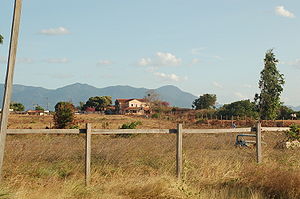
Upper Takutu-Upper Esequibo is a region of Guyana. It borders the region of Potaro-Siparuni to the north, the region of East Berbice-Corentyne to the east and Brazil to the south and west. It contains the town of Lethem, and the villages of Aishalton, Nappi and Surama. It is also the largest region of Guyana.

<span class="mw-page-title-main">Takutu River</span> River in Brazil, Guyana

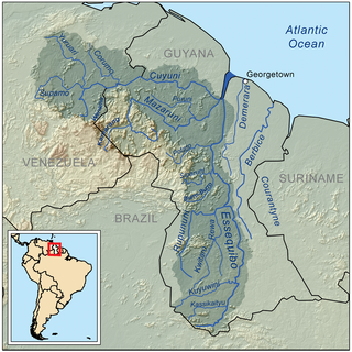
The Takutu River is a river in the Upper Takutu-Upper Essequibo Region of Guyana and Roraima in Brazil. It forms part of the boundary between the two countries. The confluence of the Takutu and Uraricoera Rivers forms the Branco River. The Takutu River's sources almost link with those of the Essequibo River; in the rainy season, flooding links the Takutu to the Rupununi River, a tributary of the Essequibo.

Dadanawa Ranch is located on the Rupununi River in the Rupununi savannah in the Upper Takutu-Upper Essequibo Region of Guyana. It is the largest and one of the most isolated cattle ranches in Guyana.

<span class="mw-page-title-main">Annai, Guyana</span> Place in Upper Takutu-Upper Essequibo, Guyana

Annai is an Amerindian village in the Upper Takutu-Upper Essequibo Region of Guyana.

Aishalton is an Amerindian village that is situated in the Rupununi savannah of southern Guyana, in the Upper Takutu-Upper Essequibo Region of the country.

<span class="mw-page-title-main">Bonfim, Roraima</span> Municipality in North, Brazil

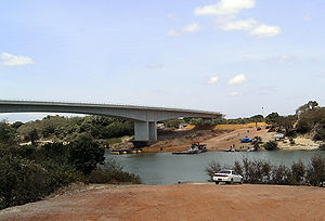
Bonfim is a municipality located in the mideast of the state of Roraima in Brazil. Its population is 12,557 and its area is 8,095 km2. The city lies opposite the Takutu River from Lethem, Guyana. The Takutu River Bridge links Bonfim and Roraima with the town of Lethem and the Atlantic port of Georgetown, Guyana.

<span class="mw-page-title-main">Guyana</span> Caribbean country in South America

Guyana, officially the Co-operative Republic of Guyana, is a country on the northern mainland of South America. Guyana is an indigenous word which means "Land of Many Waters". The capital city is Georgetown. Guyana is bordered by the Atlantic Ocean to the north, Brazil to the south and southwest, Venezuela to the west, and Suriname to the east. With a land area of 215,000 km2 (83,000 sq mi), Guyana is the third-smallest sovereign state by area in mainland South America after Uruguay and Suriname, and is the second-least populous sovereign state in South America after Suriname; it is also one of the least densely populated countries on Earth. It has a wide variety of natural habitats and very high biodiversity.

The North Rupununi District in located in south-west Guyana consisting of a mixture of forest, savannah and wetlands ecosystems and is considered one of the most diverse areas in South America. Located on the eastern margin of the larger savannah system which extends into Brazil and is separated by the Ireng and Takutu rivers that come together to form the Rio Branco. The Guyana Rupununi system is divided into the North and South Rupununi by the Kanuku Mountains.

Surama is an Amerindian village in the North Rupununi area and the Upper Takutu-Upper Essequibo Region of Guyana, with a population of 274 people as of 2012.

Hiawa is an indigenous village of Macushi Amerindians in the Upper Takutu-Upper Essequibo Region of Guyana. It is located in the Rupununi savannah. Hiawa is considered a satellite of Nappi.

Karasabai is an indigenous village of Macushi Amerindians in the Upper Takutu-Upper Essequibo Region of Guyana. It is located in the South Pakaraima Mountains, and near the Ireng River which flows south to the Amazon River.

St. Ignatius is an Amerindian village in the Upper Takutu-Upper Essequibo region of Guyana, near the regional capital Lethem and the border of Brazil. It was originally a mission founded by Jesuit priests to serve the Amerindians in the Rupununi savannah.

Karaudarnau is an indigenous village of Wapishana Amerindians in the Upper Takutu-Upper Essequibo Region of Guyana. It is located in the Rupununi savannah on the Rupununi River.

Sand Creek is a village in the Upper Takutu-Upper Essequibo Region of Guyana. Sand Creek is inhabited by Wapishana Amerindians. It is located on the Rupununi River. The main language spoken in the village is Wapishana with English as secondary language.

Nappi is an indigenous village of Macushi Amerindians in the Upper Takutu-Upper Essequibo Region of Guyana. It is located in the Rupununi savannah along the Nappi and Maipaima creeks on the edge of the Kanuku Mountains.

Maruranau is an indigenous village of Wapishana Amerindians in the Upper Takutu-Upper Essequibo Region of Guyana. It is located in the Rupununi savannah near the Kwitaro River on the edge of the Kanuku Mountains. A minority of Taruma also inhabit the village.

References

  1. 1 2 "2012 Population by Village". Statistics Guyana. Retrieved 16 August 2020.
  2. "Capital towns and economic development". Ministry of Communities. Retrieved 18 August 2020.
  3. 1 2 3 4 "Brazil and Guyana Inaugurate Border Bridge". sandiegouniontribune.com. THE ASSOCIATED PRESS. 2009-09-14. Retrieved 2015-09-08.
  4. Data from the 2002 census. Town 47
  5. "World Meteorological Organization Climate Normals for 1991-2020 — Lethem". National Oceanic and Atmospheric Administration. Retrieved January 29, 2024.

3°23′N59°48′W / 3.383°N 59.800°W / 3.383; -59.800