
Cuyuni-Mazaruni is a region of Guyana. Venezuela claims the territory as part of Guayana Esequiba.

Essequibo Islands-West Demerara is a region of Guyana.

Pomeroon-Supenaam is a region of Guyana. Venezuela claims the territory as part of Guayana Esequiba.
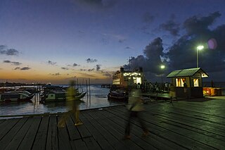
Parika is a port village located in the Essequibo Islands-West Demerara region of Guyana. Its ferry service is operated by the Ministry of Transportation, to and from the Essequibo Islands and West Demerara area. It is a hub for land transport, since it is a route stop for local taxis commonly called "buses."
The Arawak village of Wakapau is located in the Pomeroon-Supenaam Region of Guyana, on the Wakapau River, a tributary on the west bank of the Pomeroon River, 3 kilometres (1.9 mi) from its mouth. The name originates from the Lokono word ‘Wakokwãn’, which means pigeon. The village is composed of twenty inhabited islands. Some of the islands only contain a single family.
Adventure is a village located in the Pomeroon-Supenaam Region of Guyana, on the Atlantic coast, at sea level, one mile south of Onderneeming.
Anna Regina is the capital of the Pomeroon-Supenaam Region of Guyana. Anna Regina stands on the Atlantic coast, northwest of the mouth of the Essequibo River, 19 km north of Adventure, and was established as a town in 1970. Its population was 2,064 in 2012.
Annandale is a village in the Pomeroon-Supenaam Region of Guyana, located on the Atlantic coast, a few kilometres northerly of the mouth of the Essequibo River. It was formerly a sugar plantation.
Suddie is a community in the Pomeroon-Supenaam region of Guyana, located on the Atlantic Ocean, one mile north of Onderneeming.
There are several communities named Bush Lot in Guyana. This article covers four locations.
Bethany Village is a mission located on the Araburia River, a tributary three miles up the Supenaam River in Pomeroon-Supenaam, Essequibo in Guyana.

Cheddi Jagan Bio Diversity Park is a park in Lima Sands Pomeroon-Supenaam, Guyana. It was opened in 2002 in memory of former president Cheddi Jagan.

Hampton Court is a village in the Pomeroon-Supenaam region of Guyana. The village is located on the Atlantic coast. Its population was 619 in 2012. The village was known for its sugar estate and later for its rice production.
Onderneeming is a village in the Pomeroon-Supenaam region of Guyana. The village is located on the Atlantic coast. Its population was 1,095 in 2012.

Supenaam is a port village located in the Pomeroon-Supenaam region of Guyana. Supenaam is home to the ferry across the Essequibo River to Parika. The ferry is the main link between the western half of Guyana and the eastern half.

Jacklow is a village in the Pomeroon-Supenaam Region of Guyana. The village is mainly inhabited by Indo-Guyanese and Amerindian people. Jacklow is situated on the Pomeroon River.
Capoey is a village in the Pomeroon-Supenaam Region of Guyana. The village is mainly inhabited by Lokono Amerindians. It is located on Lake Capoey, a blackwater lake, which is one of largest lakes of Essequibo.
Queenstown is a village in the Pomeroon-Supenaam Region of Guyana. It is located on the Atlantic Ocean coast. It is one of the first villages where the emancipated African slaves bought the lands. Queenstown is home to the oldest extant mosque of Guyana.

Lima Sands is a village in the Pomeroon-Supenaam Region of Guyana. It is located to the west of Anna Regina. The Cheddi Jagan Bio Diversity Park is in Lima Sands.
