
Guyana is divided into 10 regions:
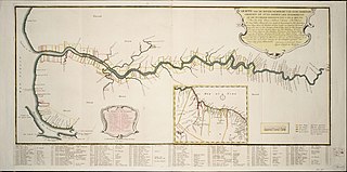
Demerara is a historical region in the Guianas, on the north coast of South America, now part of the country of Guyana. It was a colony of the Dutch West India Company between 1745 and 1792 and a colony of the Dutch state from 1792 until 1815. It was merged with Essequibo in 1812 by the British who took control. It formally became a British colony in 1815 until Demerara-Essequibo was merged with Berbice to form the colony of British Guiana in 1831. In 1838, it became a county of British Guiana until 1958. In 1966, British Guiana gained independence as Guyana and in 1970 it became a republic as the Co-operative Republic of Guyana. It was located around the lower course of the Demerara River, and its main settlement was Georgetown.

Cuyuni-Mazaruni is a region of Guyana. Its capital is Bartica, with villages including Issano, Kartabo, Kamarang, and Imbaimadai.

East Berbice-Corentyne is one of ten regions in Guyana covering the whole of the east of the country. It borders the Atlantic Ocean to the north, the Nickerie District and Sipaliwini District of Suriname to the east, Brazil to the south and the regions of Mahaica-Berbice, Upper Demerara-Berbice, Potaro-Siparuni and Upper Takutu-Upper Essequibo to the west.

Mahaica-Berbice is a region of Guyana, bordering the Atlantic Ocean to the north, the region of East Berbice-Corentyne to the east, the region of Upper Demerara-Berbice to the south and the region of Demerara-Mahaica to the west.
Demerara-Mahaica is a region of Guyana, bordering the Atlantic Ocean to the north, the region of Mahaica-Berbice to the east, the region of Upper Demerara-Berbice to the south and the region of Essequibo Islands-West Demerara to the west.

Essequibo Islands-West Demerara is a region of Guyana. It is situated around the Essequibo River, the largest river in Guyana that lies between the Orinoco and Amazon rivers of South America.

Pomeroon-Supenaam is a region of Guyana. It borders the Atlantic Ocean to the north, the region of Essequibo Islands-West Demerara to the east, the region of Cuyuni-Mazaruni to the south and the region of Barima-Waini to the west. Pomeroon-Supenaam contains the town of Anna Regina and the villages of Charity, Pickersgill, Spring Garden and Suddie. In 2012, an Official Census by the Government of Guyana listed the population of the Pomeroon-Supenaam Region at 46,810.

Upper Demerara-Berbice is a region of Guyana, bordering the regions of Essequibo Islands-West Demerara, Demerara-Mahaica and Mahaica-Berbice to the north, the region of East Berbice-Corentyne to the east, and the regions of Potaro-Siparuni and Cuyuni-Mazaruni to the west.

Potaro-Siparuni is a region of Guyana. It borders the region of Cuyuni-Mazaruni to the north, the regions of Upper Demerara-Berbice and East Berbice-Corentyne to the east, the region of Upper Takutu-Upper Essequibo to the south and Brazil to the west.
Aishalton is an Amerindian village that is situated in the Rupununi savannah of southern Guyana, in the Upper Takutu-Upper Essequibo Region of the country.
Silver Hill is a very small settlement in the Demerara-Mahaica Region of Guyana, 48 km (30 mi) up the Soesdyke-Linden Highway, which runs along the east bank of the Demerara River.
Long Creek is a village located 24.5 km up the Soesdyke-Linden Highway in the Demerara-Mahaica region of Guyana. Long Creek is hidden out of sight at the end of a trail off the highway.
Unity is a rural village in the East Coast district of the Demerara-Mahaica region of Guyana. The village is notable for being the birthplace of both Shivnarine Chanderpaul, former captain of the West Indies cricket team and Bharrat Jagdeo, former president of Guyana. Colin Croft is also from the area.
St. Cuthbert's Mission is an Amerindian village on the Mahaica River in the Demerara-Mahaica region of Guyana. It comprises approximately 200 households. St. Cuthbert's is regarded by many people in Guyana as the "cultural capital" for Amerindians.
Paradise is a village located in the Demerara-Mahaica region of Guyana, and used to be its regional capital, however the administrative building burnt down in 2006, and the regional capital moved to Triumph.

Laurens Storm van 's Gravesande was a Dutch governor of the colonies of Essequibo and Demerara from 1743 to 1772. He turned Demerara in a successful plantation colony, and the borders of Guyana are mainly based on his expeditions into the interior. He is also noted for his treatment of the Amerindians.
Triumph is a village and regional capital of the Demerara-Mahaica region in Guyana.
Helena is a village in the Demerara-Mahaica Region of Guyana. Administratively the village is subdivided in Helena No.1 and Helena No.2 and is part of the Mahaica subregion.
