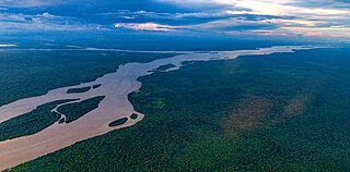
The Essequibo River is the largest river in Guyana, and the largest river between the Orinoco and Amazon. Rising in the Acarai Mountains near the Brazil–Guyana border, the Essequibo flows to the north for 1,014 kilometres (630 mi) through forest and savanna into the Atlantic Ocean. With a total drainage basin of 69,300 square kilometres (26,800 sq mi) and an average discharge of 2,104 cubic metres per second (74,300 cu ft/s).
The music of Guyana encompasses a range of musical styles and genres that draw from various influences including: Indian, Latino-Hispanic, European, African, Chinese, and Amerindian music. Popular Guyanese performers include: Terry Gajraj, Eddy Grant, Dave Martins & the Tradewinds, Aubrey Cummings, and Nicky Porter. The Guyana Music Festival has proven to be influential on the Guyana music scene.
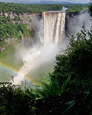
Kaieteur Falls is the world's largest single drop waterfall by the volume of water flowing over it. Located on the Potaro River in the Kaieteur National Park, it sits in a section of the Amazon rainforest included in the Potaro-Siparuni region of Guyana. It is 226 metres (741 ft) high when measured from its plunge over a sandstone and conglomerate cliff to the first break. It then flows over a series of steep cascades that, when included in the measurements, bring the total height to 251 metres (822 ft). While many falls have greater height, few have the combination of height and water volume, and Kaieteur is among the most powerful waterfalls in the world with an average flow rate of 663 cubic metres per second.

Cuyuni-Mazaruni is a region of Guyana. Venezuela claims the territory as part of Guayana Esequiba.
Potaro-Siparuni is a region of Guyana. Venezuela claims the territory as part of Guayana Esequiba.

Hosororo is a community in the Barima-Waini region of northern Guyana, on the west bank of the Aruka River, 10 km (6.2 mi) from the river's mouth, and three miles from Mabaruma.

The Potaro River is a river in Guyana in northern South America.
Annai is a small village in the Upper Takutu-Upper Essequibo Region of Guyana.

Mahdia is a town in the Potaro-Siparuni region of Guyana, located near the centre of the country at an altitude of 415 metres (1,362 ft). It is the regional capital of Mahdia.
The Arawak village of Wakapau is located in the Pomeroon-Supenaam Region of Guyana, on the Wakapau River, a tributary on the west bank of the Pomeroon River, 3 kilometres (1.9 mi) from its mouth.
Campbelltown is an Amerindian village in the Potaro-Siparuni Region of Guyana, north of Mahdia.
Princeville is an Amerindian community in the Potaro-Siparuni Region of Guyana.
Tumatumari is a community in the Potaro-Siparuni Region of Guyana, located some 15 km upstream of the confluence of the Potaro and Essequibo Rivers.

Tumatumari Landing is a small community in the Potaro-Siparuni Region of Guyana, across the Potaro River from Tumatumari, near the Konawaruk Road, and to the east of El Paso.
Micobie is a village in Potaro-Siparuni, Guyana, on the right bank of the Potaro River near Tumatumari.
Aishalton is an Amerindian village that is situated in the Rupununi savannah of southern Guyana, in the Upper Takutu-Upper Essequibo Region of the country.

Paramakatoi is a community in the Potaro-Siparuni Region of Guyana, located at 4°43′0″N59°42′0″W. With an altitude of 970 metres, it is 11 miles east of Kurukabaru.
St. Monica Karawab is a village in the Pomeroon-Supenaam region of Guyana. The village is an Amerindian village.
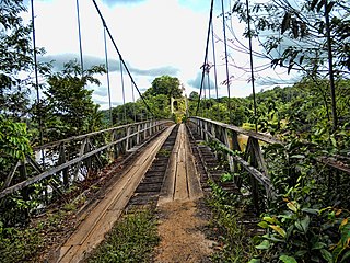
The Denham Suspension Bridge, also known as the Garraway Stream Bridge is a footbridge in Guyana linking Mahdia to Bartica. This suspension bridge was constructed over the Potaro River in an area known as Garraway Stream by a Scottish civil engineer and general contractor, John Aldi, on 6 November 1933.
