Potaro-Siparuni

Last updated
Potaro-Siparuni
Region 8
Administrative Region
GuyanaKaieteurFalls2004.jpg
Green, black, yellow flag.svg
Potaro-Siparuni in Guyana.svg
Map of Guyana showing Potaro-Siparuni region
CountryFlag of Guyana.svg  Guyana
Regional Capital Mahdia
Area
  Total20,051 km2 (7,742 sq mi)
Population
 (2012 census)
  Total10,190
  Density0.51/km2 (1.3/sq mi)
[1]

Potaro-Siparuni (Region 8) is a region of Guyana. It borders the region of Cuyuni-Mazaruni to the north, the regions of Upper Demerara-Berbice and East Berbice-Corentyne to the east, the region of Upper Takutu-Upper Essequibo to the south and Brazil to the west.

Contents

The main villages in the region are Campbelltown, Orinduik, Mahdia, Paramakatoi and Tumatumari.

Population

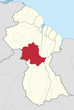
The Government of Guyana has administered three official censuses since the 1980 administrative reforms, in 1980, 1991 and 2002. [2] In 2012, the population of Potaro-Siparuni was recorded at 10,190 people. [3] Official census records for the population of Potaro-Siparuni are as follows:

Hills in the South Mahdia, Potaro Siparuni Hills in the South Mahdia - panoramio.jpg
Hills in the South Mahdia, Potaro Siparuni

Communities

(including name variants): [4]

Tourism

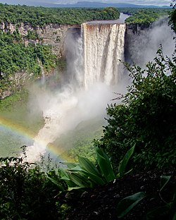
Kaieteur Falls is a major tourist attraction in Guyana. It is in Kaieteur National Park in the center of Guyana's rainforest. The park is served by Kaieteur International Airport, about a 15-minute walk from the top of Kaieteur falls, with frequent flights to Ogle Airport and Cheddi Jagan International Airport in Georgetown. Within Potaro-Siparuni is also a section of the Amazon rainforest.

Territorial claim

Venezuela has attempted to renew its claim to Guyana’s Essequibo territory, which is situated west of the Essequibo river. The status of the border controversy is subject to the Geneva Agreement, which was signed by the United Kingdom, Venezuela and British Guiana on February 17, 1966. As of December 2020, the matter is being addressed by the ICJ. [5]

Pending its final decision, the ICJ indicated the following provisional measures in its Order of 1 December 2023: [6]

(1) The Bolivarian Republic of Venezuela shall refrain from taking any action which would modify the situation that currently prevails in the territory in dispute, whereby the Co-operative Republic of Guyana administers and exercises control over that area;

(2) Both Parties shall refrain from any action which might aggravate or extend the dispute before the Court or make it more difficult to resolve.”

See also

Related Research Articles

<span class="mw-page-title-main">Barima-Waini</span> Region of Guyana

Barima-Waini is a region of Guyana and is located in the northwest of the country. Barima-Waini has three sub-regions: Mabaruma, Matakai, and Moruca.

<span class="mw-page-title-main">Kaieteur Falls</span> Waterfall on the Potaro River in Potaro-Siparuni region, Guyana

Kaieteur Falls is a single-drop waterfall on the Potaro River in Kaieteur National Park, central Essequibo Territory, Guyana. It is 226 metres (741 ft) high when measured from its plunge over a sandstone and conglomerate cliff to the first break. It then flows over a series of steep cascades that, when included in the measurements, bring the total height to 251 metres (822 ft). While many falls have greater height, few have the combination of height and water volume, and Kaieteur is among the most powerful waterfalls in the world with an average flow rate of 663 cubic metres per second. Kaieteur Falls is about four and a half times the height of Niagara Falls, on the border between Canada and the United States, and about twice the height of Victoria Falls, on the border of Zambia and Zimbabwe in Africa.

<span class="mw-page-title-main">Cuyuni-Mazaruni</span> Region of Guyana

Cuyuni-Mazaruni is a region of Guyana. Its capital is Bartica, with villages including Issano, Kartabo, Kamarang, and Imbaimadai.

<span class="mw-page-title-main">East Berbice-Corentyne</span> Region of Guyana

East Berbice-Corentyne is one of ten regions in Guyana covering the whole of the east of the country. It borders the Atlantic Ocean to the north, the Nickerie District and Sipaliwini District of Suriname to the east, Brazil to the south and the regions of Mahaica-Berbice, Upper Demerara-Berbice, Potaro-Siparuni and Upper Takutu-Upper Essequibo to the west.

<span class="mw-page-title-main">Demerara-Mahaica</span> Region of Guyana

Demerara-Mahaica is a region of Guyana, bordering the Atlantic Ocean to the north, the region of Mahaica-Berbice to the east, the region of Upper Demerara-Berbice to the south and the region of Essequibo Islands-West Demerara to the west.

<span class="mw-page-title-main">Essequibo Islands-West Demerara</span> Region of Guyana

Essequibo Islands-West Demerara is a region of Guyana. It is situated around the Essequibo River, the largest river in Guyana that lies between the Orinoco and Amazon rivers of South America.

<span class="mw-page-title-main">Upper Demerara-Berbice</span> Region of Guyana

Upper Demerara-Berbice is a region of Guyana, bordering the regions of Essequibo Islands-West Demerara, Demerara-Mahaica and Mahaica-Berbice to the north, the region of East Berbice-Corentyne to the east, and the regions of Potaro-Siparuni and Cuyuni-Mazaruni to the west.

<span class="mw-page-title-main">Upper Takutu-Upper Essequibo</span> Region of Guyana

Upper Takutu-Upper Esequibo is a region of Guyana. It borders the region of Potaro-Siparuni to the north, the region of East Berbice-Corentyne to the east and Brazil to the south and west. It contains the town of Lethem, and the villages of Aishalton, Nappi and Surama. It is also the largest region of Guyana.

<span class="mw-page-title-main">Kaieteur National Park</span>

Kaieteur National Park is a national park located in the Potaro-Siparuni Region of Guyana. The Park's boundaries and purpose are defined in the Kaieteur National Park Act, and was created to preserve the natural scenery, and its fauna and flora. There are organisms that are unique to this park and cannot be found anywhere else in the world. Of these organisms include the Anomaloglossus beebei, which is a frog that only inhabits the Brocchinia micrantha within this park and no where else in the world. The Act is administered by the Kaieteur National Park Commission.

<span class="mw-page-title-main">Potaro River</span> River in Guyana

The Potaro River is a river in Guyana that runs from Mount Ayanganna area of the Pakaraima Mountains for approximately 255 km (158 mi) before flowing into the Essequibo River, Guyana's largest river. The renowned Kaieteur Falls is on the Potaro.

Orinduik is a diamond-mining community in the Potaro-Siparuni region of Guyana near the border with Brazil.

<span class="mw-page-title-main">Mahdia, Guyana</span> Town and regional capital in Potaro-Siparuni, Guyana

Mahdia is a town in Guyana, located near the centre of the country at an altitude of 415 m (1,362 ft).

Campbelltown is an Amerindian village in the Potaro-Siparuni Region of Guyana, north of Mahdia. The village has been named after Stephen Campbell, the first Amerindian member of Parliament in Guyana.

Princeville is an Amerindian community in the Potaro-Siparuni Region of Guyana.

Tumatumari is a community in the Potaro-Siparuni Region of Guyana, located some 15 km upstream of the confluence of the Potaro and Essequibo Rivers.

<span class="mw-page-title-main">Paramakatoi</span> Place in Potaro-Siparuni, Guyana

Paramakatoi is an Amerindian community in the Potaro-Siparuni Region of Guyana, located in the Pacaraima Mountains. With an altitude of 970 metres (3,180 ft), it is 18 kilometres (11 mi) east of Kurukabaru.

<span class="mw-page-title-main">Mahdia Airport</span> Airport

Mahdia Airport is an airport serving the village of Mahdia, in the Potaro-Siparuni Region of Guyana.

Paramakatoi Airport is an airport serving the village of Paramakatoi, in the Potaro-Siparuni Region of Guyana.

<span class="mw-page-title-main">Kato, Guyana</span> Village in Potaro-Siparuni, Guyana

Kato is an indigenous village in the Potaro-Siparuni Region of Guyana. The village is mainly inhabited by Patamona people. The village is located in the Pacaraima Mountains.

References

  1. Macmillan Publishers (2009). "Administrative Regions - 8, 9 and 10". Macmillan Junior Atlas: Guyana. Oxford: Macmillan Caribbean. p. 37. ISBN   9780333934173.
  2. Beaie, Sonkarley Tiatun (19 September 2007). "Chapter 3: National Redistribution and Internal Migration" (PDF). 2002 Population and Housing Census - Guyana National Report. Bureau of Statistics. p. 51. Archived from the original (PDF) on 24 November 2007. Retrieved 29 August 2012.
  3. Beaie, Sonkarley Tiatun (19 September 2007). "National Population Trends: Size, Growth and Distribution" (PDF Download). 2002 Population and Housing Census - Guyana National Report. Bureau of Statistics. p. 25. Retrieved 29 August 2012.
  4. "2012 Population by Village". Statistics Guyana. Retrieved 8 December 2021.
  5. Summary of the Judgement of 18 December 2020
  6. https://www.icj-cij.org/sites/default/files/case-related/171/171-20231201-sum-01-00-en.pdf

4°46′11″N59°15′55″W / 4.769702°N 59.265391°W / 4.769702; -59.265391