Upper Demerara-Berbice

Last updated
Upper Demerara-Berbice
Region 10
Administrative Region
Flag yellow black 5x3.svg
Upper Demerara-Berbice in Guyana.svg
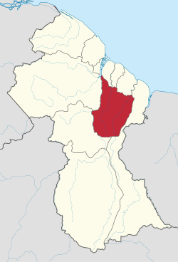
Map of Guyana showing Upper Demerara-Berbice region
Country Guyana
Regional Capital Linden
Area
  Total
17,040 km2 (6,580 sq mi)
Population
 (2022 census)
  Total
45,499
  Density2.670/km2 (6.916/sq mi)
[1]

Upper Demerara-Berbice (Region 10) is a region of Guyana, bordering the regions of Essequibo Islands-West Demerara, Demerara-Mahaica and Mahaica-Berbice to the north, the region of East Berbice-Corentyne to the east, and the regions of Potaro-Siparuni and Cuyuni-Mazaruni to the west.

Contents

It contains Guyana's second largest city, Linden, with notable villages including Ituni, Kwakwani, Kurupukari, Rockstone and Takama.

Kimbia is the first training center to house the Guyana National Service. The Pioneer Corps was started in 1974, with the establishment of Kimbia Center on the Berbice River. [2]

Population

The Government of Guyana has administered three official censuses since the 1980 administrative reforms, in 1980, 1991, 2002, 2012 and 2022. [3] [4] In 2012, the population of Upper Demerara-Berbice was recorded at 39,452 people. [5] Official census records for the population of the Upper Demerara-Berbice region are as follows:

Communities

(including name variants): [6]

References

  1. Macmillan Publishers (2009). "Administrative Regions - 8, 9 and 10". Macmillan Junior Atlas: Guyana. Oxford: Macmillan Caribbean. p. 37. ISBN   9780333934173.
  2. "The Guyana National Service". Stabroek News. Retrieved 19 August 2020.
  3. Beaie, Sonkarley Tiatun (19 September 2007). "Chapter 3: National Redistribution and Internal Migration" (PDF). 2002 Population and Housing Census - Guyana National Report. Bureau of Statistics. p. 51. Archived from the original (PDF) on 17 February 2012. Retrieved 29 August 2012.
  4. https://www.citypopulation.de/en/guyana/
  5. Beaie, Sonkarley Tiatun (19 September 2007). "National Population Trends: Size, Growth and Distribution" (PDF Download). 2002 Population and Housing Census - Guyana National Report. Bureau of Statistics. p. 25. Retrieved 29 August 2012.
  6. "2012 Population by Village". Statistics Guyana. Retrieved 8 December 2021.

5°16′09″N58°16′01″W / 5.269126°N 58.267074°W / 5.269126; -58.267074