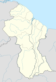
The Geography of Guyana comprises the physical characteristics of the country in Northern South America and part of Caribbean South America, bordering the North Atlantic Ocean, between Suriname and Venezuela, with a land area of approximately 214,969 square km. The country is situated between 1 and 9 north latitude and between 56 and 62 west longitude. With a 459 km (285 mi)-long Atlantic coastline on the northeast, Guyana is bounded by Venezuela on the west, Brazil on the west and south, and Suriname on the east.
Trans Guyana Airways Limited is a Guyanese airline which commenced operations in 1956 in Georgetown, Guyana, with a single float airplane. Since then, the company has expanded their fleet to provide domestic and regional transportation, and to Guyana's remote areas.

Kaieteur Falls is the largest single-drop waterfall in the world. It is located on the Potaro River in Kaieteur National Park, central Essequibo Territory, Guyana. It is 226 metres (741 ft) high when measured from its plunge over a sandstone and conglomerate cliff to the first break. It then flows over a series of steep cascades that, when included in the measurements, bring the total height to 251 metres (822 ft). While many falls have greater height, few have the combination of height and water volume, and Kaieteur is among the most powerful waterfalls in the world with an average flow rate of 663 cubic metres per second. Kaieteur Falls is about four and a half times the height of Niagara Falls, on the border between Canada and the United States, and about twice the height of Victoria Falls, on the border of Zambia and Zimbabwe in Africa.

Potaro-Siparuni is a region of Guyana. It borders the region of Cuyuni-Mazaruni to the north, the regions of Upper Demerara-Berbice and East Berbice-Corentyne to the east, the region of Upper Takutu-Upper Essequibo to the south and Brazil to the west.

Kaieteur National Park is a national park located in the Potaro-Siparuni Region of Guyana, roughly 633 km south of Georgetown, the nation's capital, closer to the border with Brazil than to the Caribbean coast. It is widely considered the country's only national park, as the capital's National Park is a not a true wilderness reserve. Kaieteur is part of the Guianan moist forests ecoregion. The main tourist attraction in the park is Kaieteur Falls, considered the largest single-drop waterfall anywhere on earth, by volume of water. Orinduik Falls is another water-feature in the park, a series of smaller, cascading waterfalls. There is a popular swimming hole located at Orinduik.

The Potaro River is a river in Guyana that runs from Mount Ayanganna area of the Pakaraima Mountains for approximately 255 km (158 mi) before flowing into the Essequibo River, Guyana's largest river. The renowned Kaieteur Falls is on the Potaro.

The Orinduik Falls lie on the Ireng River, a highland river that thunders over steps and terraces of red jasper on the border of Guyana and Brazil before merging with the Takutu River and into Brazil to join the Amazon River.

The White Diamond is a 2004 documentary film by Werner Herzog. It illustrates the history of aviation and depicts the struggles and triumphs of Graham Dorrington, an aeronautical engineer, who has designed and built a teardrop-shaped airship which he plans to fly over the forest canopies of Guyana. It features music composed by Ernst Reijseger, which was re-used in Herzog's 2005 film The Wild Blue Yonder.

Roraima Airways is a regional airline of Guyana with its main hub at the Eugene F. Correia International Airport. Roraima Airways was founded in 1992.

Lethem Airport is an airport serving Lethem, a town in the Upper Takutu-Upper Essequibo region of Guyana. The airport has an 1,825-meter long, asphalt-surface runway.

Annai Airport is an airport serving the village of Annai, in the Upper Takutu-Upper Essequibo Region of Guyana. The 1,000-meter runway has 640 metres (2,100 ft) of asphalt paving, with the remainder grass.
Bartica Airport is an airport serving the town of Bartica, in the Cuyuni-Mazaruni Region of Guyana. The airport's only runway is a 760-meter asphalt strip.
Karanambo Airport is an airport serving the village of Karanambo, in the Upper Takutu-Upper Essequibo Region of Guyana. The 1,372-meter long runway is a dirt surface.
Mabaruma Airport is an airport serving the town of Mabaruma, capital of the Barima-Waini Region of Guyana.
Paruima Airport is an airport serving the community of Paruima in the Cuyuni-Mazaruni Region of Guyana.
The COVID-19 pandemic in Guyana was a part of the worldwide pandemic of coronavirus disease 2019 caused by severe acute respiratory syndrome coronavirus 2. The virus was confirmed to have reached Guyana on 11 March 2020. The first case was a woman who travelled from New York, a 52-year-old woman with underlying health conditions, including diabetes and hypertension. The woman died at the Georgetown Public Hospital.
Tourism in Guyana is a fledgling industry compared to other countries in the Caribbean. Tourism is mainly focused on ecotourism, and accommodations for business travelers. Guyana is home to Kaieteur Falls, Mount Roraima, and St. George's Cathedral.
Paramakatoi Airport is an airport serving the village of Paramakatoi, in the Potaro-Siparuni Region of Guyana.

Kato is an indigenous village in the Potaro-Siparuni Region of Guyana. The village is mainly inhabited by Patamona people. The village is located in the Pacaraima Mountains.


