
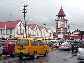
Georgetown is the capital and largest city of Guyana. It is situated in Demerara-Mahaica, region 4, on the Atlantic Ocean coast, at the mouth of the Demerara River. It is nicknamed the "Garden City of the Caribbean." It is the retail, administrative, and financial services centre of the country, and the city accounts for a large portion of Guyana's GDP. The city recorded a population of 118,363 in the 2012 census.

Guyana is divided into 10 Regions:

Demerara is a historical region in the Guianas, on the north coast of South America, now part of the country of Guyana. It was a Dutch colony until 1815 and a county of British Guiana from 1838 to 1966. It was located around the lower course of the Demerara River, and its main settlement was Georgetown.

The Guianas, sometimes called by the Spanish loan-word Guayanas, is a region in north-eastern South America which includes the following three territories:
Nonpareil also Non Pareil was the name of a sugarcane plantation, and later a village, on the east coast Demerara Region of Guyana that operated until the mid 20th century. Although the factory and village were torn down and disassembled in the 1940s, its population survived and formed the majority of the population of Enterprise, a modern village located one mile away from the site of old Nonpareil.

Cuyuni-Mazaruni is a region of Guyana. Venezuela claims the territory as part of Guayana Esequiba.
Demerara-Mahaica is a region of Guyana, bordering the Atlantic Ocean to the north, the region of Mahaica-Berbice to the east, the region of Upper Demerara-Berbice to the south and the region of Essequibo Islands-West Demerara to the west.

Essequibo Islands-West Demerara is a region of Guyana.
Rosignol is a village on the west bank of the Berbice River in Mahaica-Berbice, Guyana.
Enmore is a village in the Demerara-Mahaica region along the coastal belt of Guyana. It is about two square miles (5.1 km2) in size and has a multi-ethnic population of 1,002 as of 2012, with large concentrations of Indo-Guyanese.
Annandale is a community in the Demerara-Mahaica region of Guyana, located on the Atlantic Ocean between Buxton, and Lusignan. Many of the inhabitants originally came from the Lusignan estate, while the former slaves of the plantation, bought the neighbouring Orange Nassau plantation and named it Buxton. Annandale is mainly an Indo-Guyanese community. It is divided in Annandale North, South, West and Courabane Park. The economy used to be dependent on the nearby sugar estates. The secondary school for the region is located in Annandale.

Clonbrook is a village in the Demerara-Mahaica region of Guyana. The village itself has a population of about 1,193 as of 2012. The village is located along the East Coast Highway and is about 16.5 miles from Georgetown and about 6 miles from Mahaica. It is bordered in the east by the village of Bee Hive and by Ann's Grove in the west.
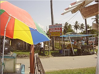
Enterprise is a village in the Demerara-Mahaica region along the coastal belt of Guyana. It is about two square miles in size and has a population of 2,657 as of 2012. It is located about 14 miles (23 km) southeast of the capital city Georgetown. This small community is flanked by Bachelors Adventure and a little further, Enmore to the east; Strasthpey on its west; Melanie Damishana and the Atlantic Ocean sits to the North. Some of the country's largest sugarcane fields are just beyond its southern horizon.

Guyana, officially the Co‑operative Republic of Guyana, is a country on the northern mainland of South America. Guyana is an indigenous word which means "Land of Many Waters". The capital city is Georgetown. Guyana is bordered by the Atlantic Ocean to the north, Brazil to the south and southwest, Venezuela to the west, and Suriname to the east. With 215,000 km2 (83,000 sq mi), Guyana is the third-smallest sovereign state by area in mainland South America after Uruguay and Suriname, and is the second-least populous sovereign state in South America after Suriname; it is also one of the least densely populated countries on Earth. It has a wide variety of natural habitats and very high biodiversity.
Leonora is a village in Essequibo Islands-West Demerara, one of Guyana's 10 regions. Its subdivisions are Pasture, Sea Field, Para Field, Groenveldt and Sea Spray. The neighboring villages are Anna Catherina and Uitvlugt. Leonora encompasses an area of about 13 square kilometres (5 sq mi), once part of the Parish of St. Luke. It stretches from Edinburgh in the east to Stewartville in the west, and from the Atlantic Ocean in the north, to the south as far as the West Demerara Water Conservancy.
Uitvlugt is a village in the Essequibo Islands-West Demerara region of Guyana. On the coastal public road on the west bank of the Demerara River, it lies immediately to the west of Stewartville and to the south of Zeeburg, about 20 minutes by road from Vreed-en-Hoop.
Soesdyke is a village in the Demerara-Mahaica Region, Guyana, located between the Demerara River and the East Bank Public Road. Soesdyke is located just after the village called Den Heuvel (Coverden) if you are coming from Georgetown, which is the capital of Guyana. On the other end of Soesdyke is the village Timehri about 3 miles northeast of the Cheddi Jagan International Airport.
Goed Fortuin is a village located in the Essequibo Islands-West Demerara region of Guyana. The village started as a sugar plantation in the early 1800s.
Vriesland is a village in the Essequibo Islands-West Demerara Region of Guyana. It is located on the west bank of the Demerara River.
Tuschen is a village in the Essequibo Islands-West Demerara Region of Guyana. It is located along the Atlantic Ocean coast. The original name of the village was Tuschen de Vrienden. During the 20th century, it was a small village. The Tuschen Housing Scheme resulted in a considerable growth, and is one of the largest housing schemes in Guyana.
