
The Arawak are a group of indigenous peoples of northern South America and of the Caribbean. Specifically, the term "Arawak" has been applied at various times to the Lokono of South America and the Taíno, who historically lived in the Greater Antilles and northern Lesser Antilles in the Caribbean. All these groups spoke related Arawakan languages.

Mabaruma is the administrative centre for Region One (Barima-Waini) of Guyana. It is located close to the Aruka River on a narrow plateau above the surrounding rainforest at an elevation of 13 metres.

Mahaica-Berbice is a region of Guyana, bordering the Atlantic Ocean to the north, the region of East Berbice-Corentyne to the east, the region of Upper Demerara-Berbice to the south and the region of Demerara-Mahaica to the west.
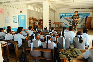
Santa Rosa is a community in the Barima-Waini region of northern Guyana. Santa Rosa mission was established in 1840, and is one of the earliest Catholic Missions in Guyana. The village is part of the North West Amerindian District.
Assakata or Asakata is a village in Barima-Waini region, in the north of Guyana. Assakata is an Amerindian village inhabited by Warao and Arawak people, located in the swamps and marshes between the Barima and Pomeroon River.

Mahdia is the capital of the Potaro-Siparuni region of Guyana, located near the centre of the country at an altitude of 415 metres (1,362 ft).
Kabakaburi is an Amerindian village in the Pomeroon-Supenaam Region of Guyana on the Pomeroon River, 56 km (35 mi) from its mouth. The village was founded in 1845 by William Henry Brett on the location where Fort Durban used to be.
The Arawak village of Wakapau is located in the Pomeroon-Supenaam Region of Guyana, on the Wakapau River, a tributary on the west bank of the Pomeroon River, 3 kilometres (1.9 mi) from its mouth. The name originates from the Lokono word ‘Wakokwãn’, which means pigeon. The village is composed of twenty inhabited islands. Some of the islands only contain a single family.
Mora Point, on the Mahaicony River in the Mahaica-Berbice Region of Guyana, is a village located 18 km south of the East Coast Highway.
Campbelltown is an Amerindian village in the Potaro-Siparuni Region of Guyana, north of Mahdia. The village has been named after Stephen Campbell, the first Amerindian member of Parliament in Guyana.

Tumatumari Landing is a small community in the Potaro-Siparuni Region of Guyana, across the Potaro River from Tumatumari, near the Konawaruk Road, and to the east of El Paso.
Belladrum is a small community in the Mahaica-Berbice Region of Guyana, on the Atlantic coast, about 15 kilometres (9 mi) east of Mahaicony.
Koriabo is a community in the Barima-Waini region of Guyana, standing at an altitude of 36 metres. Barima and Koriba form an Amerindian community which is mainly inhabited by Warao people with a minority of Arawak and Kalina people.
St. Monica Karawab is a village in the Pomeroon-Supenaam region of Guyana. The village is an Amerindian village.

Mainstay Lake is a lake in the Pomeroon-Supenaam Region of Guyana, near the Atlantic coast, northwest of the mouth of the Essequibo River, 12 mi (19 km) north of Adventure. There is a 0.5 mi (0.80 km) stretch of white sand at the edge of the lake.

The Taíno were a historic indigenous people of the Caribbean, whose culture has been continued today by Taíno descendant communities and Taíno revivalist communities. At the time of European contact in the late 15th century, they were the principal inhabitants of most of what is now Cuba, Dominican Republic, Jamaica, Haiti, Puerto Rico, the Bahamas, and the northern Lesser Antilles. The Lucayan branch of the Taíno were the first New World peoples encountered by Christopher Columbus, in the Bahama Archipelago on October 12, 1492. The Taíno spoke a dialect of the Arawakan language group. They lived in agricultural societies ruled by caciques with fixed settlements and a matrilineal system of kinship and inheritance. Taíno religion centered on the worship of zemis.
St. Cuthbert's Mission is an Amerindian village on the Mahaica River in the Demerara-Mahaica region of Guyana. It comprises approximately 200 households. St. Cuthbert's is regarded by many people in Guyana as the "cultural capital" for Amerindians.

Indigenous peoples in Guyana, Native Guyanese, or Amerindian Guyanese are Guyanese people who are of indigenous ancestry. They comprise approximately 9.16% of Guyana's population. Amerindians are credited with the invention of the canoe, as well as Cassava-based dishes and Guyanese pepperpot, the national dish of Guyana. Amerindian languages have also been incorporated in the lexicon of Guyanese Creole.
The Lokono or Arawak are an Arawak people native to northern coastal areas of South America. Today, approximately 10,000 Lokono live primarily along the coasts and rivers of Venezuela, Guyana, Suriname, Barbados and French Guiana. They speak the Arawak language, the eponymous language of the Arawakan language family, as well as various Creole languages, and English.
St. Ignatius is an Amerindian village in the Upper Takutu-Upper Essequibo region of Guyana, near the regional capital Lethem and the border of Brazil. It was originally a mission founded by Jesuit priests to serve the Amerindians in the Rupununi savannah.
