Mazaruni River

Last updated

Mazaruni River
Mazaruni Prison HDR - panoramio.jpg
Location
Country Guyana
Physical characteristics
Source 
  location Pakaraima Mountains, Guyana
  coordinates 5°36′50.22″N59°57′19.4292″W / 5.6139500°N 59.955397000°W / 5.6139500; -59.955397000
  elevation870 m (2,850 ft)
Mouth Cuyuni
  coordinates
6°22′50.4264″N58°41′6.0612″W / 6.380674000°N 58.685017000°W / 6.380674000; -58.685017000
  elevation
1 m (3 ft 3 in)
Length560 km (350 mi)
Basin size31,704.8 km2 (12,241.3 sq mi) [1]
Discharge 
  locationNear mouth
  average(Period: 1971–2000)1,398.7 m3/s (49,390 cu ft/s) [1]
Basin features
Progression CuyuniEssequiboAtlantic Ocean
Tributaries 
  leftHaieka, Kako, Kukui, Kamarang, Puruni
  rightKurupung, Merume, Karanang, Semang, Issano, Kaburi
Map of the Essequibo drainage basin with the Mazaruni just above center Essequiborivermap.png
Map of the Essequibo drainage basin with the Mazaruni just above center

The Mazaruni River is a tributary of the Essequibo River in northern Guyana. Its source is in the remote western forests of the Pakaraima Mountains and its confluence with the Cuyuni River is near Bartica. As it descends from the Guiana Highlands the river runs south-east, past Issano, then northward to Bartica. The river is a source of alluvial gold.

Contents

Sources

Roraima Plateau is the source of the river Kukenan Tepuy at Sunset.jpg
Roraima Plateau is the source of the river

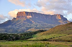
The river takes source in the Roraima Plateau, three levels of sandstones and conglomerates, crowned by Mt. Roraima (2,810 m (9,220 feet)). In Guyana, the two highest levels of the Roraima Plateau are known as Pakaraima Mountains and Merume Mountains. The source of the Mazarunu River is in the Merume Mountains. The area is one of the very few places in the world still inaccessible. In 1992, a joint expedition of the Guyana Defence Force and Welsh Guards members was unable to reach the source of Mazaruni River, even with training, finances and equipment.

Course

The river drops down from each Roraima plateau through three steep sided canyons with many picturesque sets of falls. The first set is Chai-chai Falls. The next is near village of Imbaimadai and the last set is below the village of Kamarang where the Mazaruni River tumbles through last few major falls, the first of which is a few kilometres long gutter known as Chitigokein Falls, which finishes in Coffy pool, a deep pool named after Mehir "Cousin Body" Coffy, one of the last pork-knockers (small-scale diamond and gold miners) of Guyana. The term "Porknockers" comes from the old prospectors having to carry in all their food one of which was salt pork which attracted flies and had to be knocked regularly to keep flies away. According to legend, during the 1950s, Coffy was diving in the river for diamonds when he got the bends, due to overstaying below and rapid decompression.

After few kilometres of relatively calm water, the last set of great Mazaruni River Falls begin. The first falls is the Aruwai Falls and the last is the Peaima Falls.

Soon after Peaima Falls, the river, which was flowing north–south, turns east-south-east. It passes the Isseneru River mouth on the left bank, with the Amerindian village, Isseneru, [2] on the other bank. Then, over the lowlands of greenstones of Precambrian Guiana Shield, the Meamu River, Kurupung River and Eping River join the Mazaruni River. Together, these rivers serve to drain the highlands of the Merume Mountains.

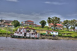
Next, the Mazaruni River flows past Oranapai Rapids, Kamakusa Landing, the mouth of Merume River, Banana Landing, Tiboku Rapids, the mouth of Equeribisi River, Issano Landing, the mouth of the Puruni River, Kaburi rapids, Marshal Falls, the last set of rapids, Itabali Landing, the mouth of the Cuyuni River, then, near the village of Bartica, finishes into the Essequibo River, the largest river of Guyana.

Fauna

The iron hydroxide stained brown waters of Mazaruni are home to many fish. The most abundant are the large and dangerous black electric eels (numfish), piry (relative of piranha cutleback), haimara, and baiara. However, the most famous fish is lau-lau, with specimens weighing up to 200 kg (440 pounds). Lau-lau lives in deep pools of Mazaruni River hunting in the night. The waters are also home to a largest water snake, that is anaconda, locally known as the "water kamudi." Large herds of peccaries which sometimes number into the hundreds, live on swampy flat of the river. Pumas and the much smaller ocelot are also found there but rarely seen since they hunt at night. Many monkeys, of which the howling monkey is the noisiest, inhabit tree tops, sharing the space with many types of birds. Pairs of red, yellow or bleu Macaws, united for life, often can be seen to fly by.

In 2015, a jaguar attacked a three-year-old indigenous girl near the river, in Cuyuni-Mazaruni. She nevertheless survived. [3]

Flora

The Mazaruni River flows over three distinct habitats; the flat tops of Roraima Plateau, known in Venezuela as “tepuis”, the lower two plateaus and the low lands. Each habitat is characterised by its own vegetation. The upper one is a fantastic land of rain swept sandstone eroded into fantastic forms with exotic plants trying to survive this inhospitable land of denuded rocks. The middle one is mainly savannas with bands of single canopy jungle, the lowest is a triple canopy jungle. Exotic orchids are found in last two habitats.

Mineral resources

In the upper Mazaruni River basin, in 1890, near Isseneru village, first alluvial diamonds were found in Guyana. [4] The discovery was made accidentally by Edward Gilkes, was prospecting for gold along the Putareng Creek, a small left hand tributary of the Mazaruni River. Since then, according to Guyana Geology and Mines Commission, Mazaruni River, along with its tributaries (Meamu, Kurupung and Eping Rivers), produced over 50 percent all of alluvial diamonds mined up to now in Guyana.

The gravels of Mazaruni River and its tributaries are, as well, gold bearing. Some places, such as Imbaimadai, Kamarang, Aruwai, Tiboku, Kaburi and Marshal Falls produced a large amount of alluvial gold during golden era of river dredging (1980–1995).

The river remains, to a lesser degree, a source of alluvial gold and diamonds. A few miles west of Bartica, there was an unsuccessful attempt to establish a hard-rock gold mine in 1888.

See also

Related Research Articles

The Geography of Guyana comprises the physical characteristics of the country in Northern South America and part of Caribbean South America, bordering the North Atlantic Ocean, between Suriname and Venezuela, with a land area of approximately 214,969 square km. The country is situated between 1 and 9 north latitude and between 56 and 62 west longitude. With a 459 km (285 mi)-long Atlantic coastline on the northeast, Guyana is bounded by Venezuela on the west, Brazil on the west and south, and Suriname on the east.

<span class="mw-page-title-main">Essequibo River</span> Major river in Guyana

The Essequibo River is the largest river in Guyana, and the largest river between the Orinoco and Amazon. Rising in the Acarai Mountains near the Brazil–Guyana border, the Essequibo flows to the north for 1,014 km (630 mi) through forest and savanna into the Atlantic Ocean. It has a total drainage basin of 156,828 km2 (60,552 sq mi) and an average discharge of 5,650 m3/s (200,000 cu ft/s).

<span class="mw-page-title-main">Bartica</span> Town and regional capital in Cuyuni-Mazaruni, Guyana

Bartica, Essequibo, is a town on the left bank of the Essequibo River in Cuyuni-Mazaruni, at the confluence of the Cuyuni and Mazaruni Rivers with the Essequibo River in Guyana. It is the regional capital of Cuyuni-Mazaruni.

<span class="mw-page-title-main">Cuyuní River</span> River in Venezuela and Guyana

The Cuyuni River is a South American river and a tributary of the Essequibo River. It rises in the Guiana Highlands of Venezuela, where it descends northward to El Dorado, and turns eastward to meander through the tropical rain forests of the Cuyuni-Mazaruni Region of Guyana. It finally turns southeastward, flowing to its confluence with the Mazaruni River.

<span class="mw-page-title-main">Kaieteur Falls</span> Waterfall on the Potaro River in Potaro-Siparuni region, Guyana

Kaieteur Falls is a single-drop waterfall on the Potaro River in Kaieteur National Park, central Essequibo Territory, Guyana. It is 226 metres (741 ft) high when measured from its plunge over a sandstone and conglomerate cliff to the first break. It then flows over a series of steep cascades that, when included in the measurements, bring the total height to 251 metres (822 ft). While many falls have greater height, few have the combination of height and water volume, and Kaieteur is among the most powerful waterfalls in the world with an average flow rate of 663 cubic metres per second. Kaieteur Falls is about four and a half times the height of Niagara Falls, on the border between Canada and the United States, and about twice the height of Victoria Falls, on the border of Zambia and Zimbabwe in Africa.

<span class="mw-page-title-main">Cuyuni-Mazaruni</span> Region of Guyana

Cuyuni-Mazaruni is a region of Guyana. Its capital is Bartica, with villages including Issano, Kartabo, Kamarang, and Imbaimadai.

The Pacaraima or Pakaraima Mountains are a mountain range primarily in southwestern Guyana, and into northern Brazil and eastern Venezuela.

<span class="mw-page-title-main">Potaro-Siparuni</span> Region of Guyana

Potaro-Siparuni is a region of Guyana. It borders the region of Cuyuni-Mazaruni to the north, the regions of Upper Demerara-Berbice and East Berbice-Corentyne to the east, the region of Upper Takutu-Upper Essequibo to the south and Brazil to the west.

<span class="mw-page-title-main">Potaro River</span> River in Guyana

The Potaro River is a river in Guyana that runs from Mount Ayanganna area of the Pakaraima Mountains for approximately 255 km (158 mi) before flowing into the Essequibo River, Guyana's largest river. The renowned Kaieteur Falls is on the Potaro.

Imbaimadai is a community in the Cuyuni-Mazaruni Region of Guyana.

<span class="mw-page-title-main">Kamarang</span> Village in Cuyuni-Mazaruni, Guyana

Kamarang is an Amerindian village, standing at the confluence of the Kamarang River and Mazaruni River, in the Cuyuni-Mazaruni Region of Guyana.

Kurupung is a mining community in the Cuyuni-Mazaruni Region of Guyana, near the Pakaraima Mountains.

<span class="mw-page-title-main">Kamarang River</span> River in Guyana, Venezuela

Kamarang River is a river in Guyana and Venezuela, and a part of the Essequibo River basin.

The Kako River is a river in the Cuyuni-Mazaruni region of Guyana and one of the largest tributaries of the Mazaruni River.

The Merume River is a river of Guyana, a tributary of the Kamarang River.

The Bartica Massacre refers to the murder of twelve residents of Bartica, Cuyuni-Mazaruni, Guyana, murdered by the criminal gang led by Rondell "Fineman" Rawlins. Rawlins and many of the other suspected gang members were later killed by Guyanese security forces. This massacre was part of a series of murders that appeared to have begun with the Mash Day Prison break.

Maringma-tepui, also written Mount Maringma and historically known as Mount Marima, is a small tepui of the Pacaraima Mountains in Cuyuni-Mazaruni, Guyana. It is known as Malaima-tepui in the local Akawaio language. Most published sources place it just inside Guyanese territory, very close to the border with Brazil, and around 17 kilometres (11 mi) east of Roraima-tepui. However, the mountain remains the subject of considerable toponymic confusion and its name has been applied to at least one other nearby peak.

Issano is a village of Cuyuni-Mazaruni, Guyana. It's located along the Mazaruni River, and is a hub for mining.

Isseneru is an Amerindian settlement in the Cuyuni-Mazaruni region of Guyana, approximately 15–20 miles west of Kurupung.

References

  1. 1 2 "Atlantic North Coast".
  2. "Isseneru". Stabroek News. October 27, 2013. Retrieved January 18, 2021.
  3. Francis, Adama M.; Iserson, K. V. (2015). "Jaguar Attack on a Child: Case Report and Literature Review". Western Journal of Emergency Medicine. 16 (2): 303–309. doi:10.5811/westjem.2015.1.24043. PMC   4380383 . PMID   25834674.
  4. Venezuela and Guyana diamond deposits, geology, exploration, mining, use - Part I

6°25′N58°38′W / 6.417°N 58.633°W / 6.417; -58.633