Waini River

Last updated
Waini River
Temporary Home in the Wini River - panoramio.jpg
Guyana physical map.svg
Red pog.svg
Location of mouth
Location
Country Guyana [1]
Region Barima-Waini
Physical characteristics
Source 
  location [1] [2]
  coordinates 7°00′N59°24′W / 7.0°N 59.4°W / 7.0; -59.4
Mouth Atlantic Ocean
  location
Waini Point [1] [3]
  coordinates
8°23′25″N59°50′14″W / 8.390186°N 59.837208°W / 8.390186; -59.837208
  elevation
Sea level [1]
Basin features
Tributaries 
  left"Left" is in the sense source to mouth but tributaries are listed mouth to source [1]
Mora Passage
Warapoko
Sabaina River
Arasika
Barama River
(Village of Santa Cruz)
Kumanaballi
Matorohana
Anaida
Arawatta
Ananu
Two Mouth
Ariaparu
Pelibelimba
Turubang
Yamira
Durabanna
Imotai
Kasipang
Source of Waini River.
  right"Right" is in the sense source to mouth but tributaries are listed mouth to source [1] [4]
Thunder Creek
Kuberina
Mokaboina
Luri
Baramanni
Barukabaru
Kumaruwa
Kuniaballi
(Village of Santa Cruz)
Sirikata River
Kuiaru River
Mubohina River
Kwabanna
Kwassi
Anapari
Akabaru
Mariwaru
Urabubaru
Potawau
Turtle
Shararin
Arawapai
Source of Waini River.

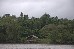
The Waini River is a river in the Barima-Waini region of northern Guyana. It flows into the Atlantic Ocean near the border with Venezuela. The upper portion of the river flows through the Guianian moist forests, while the lower Waini river flows through the eastern extent of the vast Orinoco Delta swamp forests before emptying into the sea.

Contents

Features

Almond Beach at the mouth of the Waini River is one of the most important nesting areas for leatherback, green, hawksbill and the olive ridley marine turtles. [5] It is the only place in Guyana that has a large stretch of intact mangrove forest, brackish water and coastal swamp communities.

There are three significant waterfalls along the Waini. [1] The furthest up river is Kasatu Falls at 7°13′25″N59°21′33″W / 7.22366°N 59.3591°W / 7.22366; -59.3591 . [6] [7]

Settlements along the river include Santa Cruz [1] and Santa Rosa, an Amerindian community.

See also

Related Research Articles

The Geography of Guyana comprises the physical characteristics of the country in Northern South America and part of Caribbean South America, bordering the North Atlantic Ocean, between Suriname and Venezuela, with a land area of approximately 214,969 square km. The country is situated between 1 and 9 north latitude and between 56 and 62 west longitude. With a 459 km (285 mi)-long Atlantic coastline on the northeast, Guyana is bounded by Venezuela on the west, Brazil on the west and south, and Suriname on the east.

<span class="mw-page-title-main">Essequibo River</span> Major river in Guyana

The Essequibo River is the largest river in Guyana, and the largest river between the Orinoco and Amazon. Rising in the Acarai Mountains near the Brazil–Guyana border, the Essequibo flows to the north for 1,014 km (630 mi) through forest and savanna into the Atlantic Ocean. It has a total drainage basin of 156,828 km2 (60,552 sq mi) and an average discharge of 5,650 m3/s (200,000 cu ft/s).

<span class="mw-page-title-main">Barima-Waini</span> Region of Guyana

Barima-Waini is a region of Guyana and is located in the northwest of the country. Barima-Waini has three sub-regions: Mabaruma, Matakai, and Moruca.

<span class="mw-page-title-main">Port Kaituma</span> Place in Barima-Waini, Guyana

Port Kaituma is a small village within the Barima-Waini administrative region of Guyana. It became known internationally as a gateway village to the Peoples Temple settlement in nearby Jonestown. It has long been a hub for mining in the area.

<span class="mw-page-title-main">Santa Rosa, Guyana</span> Place in Barima-Waini, Guyana

Santa Rosa is a community in the Barima-Waini region of northern Guyana. Santa Rosa mission was established in 1840, and is one of the earliest Catholic Missions in Guyana. The village is part of the North West Amerindian District.

The Moruka River or Moruca River is a river in the Barima-Waini region of northern Guyana.

Assakata or Asakata is a village in Barima-Waini region, in the north of Guyana. Assakata is an Amerindian village inhabited by Warao and Arawak people, located in the swamps and marshes between the Barima and Pomeroon River.

Hosororo is a community in the Barima-Waini region of northern Guyana, on the west bank of the Aruka River, 10 km (6.2 mi) from the river's mouth, and three miles from Mabaruma.

<span class="mw-page-title-main">Black River (Jamaica)</span> River in Jamaica

The Black River is one of the longest rivers in Jamaica. At a length of 53.4 km (33.2 mi), it was believed to be the longest until it was discovered that the Rio Minho was 92.8 km long. Its name refers to the darkness of the river bed caused by thick layers of decomposing vegetation. Over 100 species of birds have been recorded in the Black River morass.

<span class="mw-page-title-main">Treasure Beach</span> Beach Resort in St Elizabeth, Jamaica

Treasure Beach is the name given to a stretch of four Jamaican coves and their associated settlements: Billy's Bay, Frenchman's Bay, Calabash Bay and Great (Pedro) Bay.

<span class="mw-page-title-main">Devi River</span> River in India

Devi river is one of the principal distributaries of Mahanadi. It flows through Jagatsinghpur district and Puri district across Odisha state in India and joins Bay of Bengal.

The Barama River is a tributary of the Waini River, both being in the Barima-Waini administrative region of Guyana.

The Kaituma River is a river of Guyana in the Barima-Waini region. The mouth is at the upper Barima River, and the area is made up of mostly mangrove swamps.

The Cane River rises at twin sources in the vicinity of Derby Peak in eastern Saint Andrew Parish, Jamaica from where it flows south to the Caribbean Sea.

The Dry River is a river in St Mary, Jamaica.

<span class="mw-page-title-main">Great River (Jamaica)</span> River in Jamaica

The Great River (Jamaica) is one of Jamaica's major rivers, and forms the boundary of the parish of St James with Westmoreland and Hanover.

<span class="mw-page-title-main">South Negril River</span> River in Jamaica

The South Negril River is a river in Westmoreland, Jamaica.

<span class="mw-page-title-main">Turtle River (Georgia)</span> River in Georgia, United States

The Turtle River is a 17.6-mile-long (28.3 km) tidal river in the vicinity of Brunswick in Glynn County, Georgia. It is the main tributary of the Brunswick River.

The Rotten Gut River is a short river in the parish of Manchester, Jamaica and a tributary of the One Eye River.

<span class="mw-page-title-main">Pagee River</span> River in Saint Mary, Jamaica

The Pagee River rises on the south eastern flank of Berry Hill just below the 1,000 ft (300 m) contour at 18.29488°N 76.92817°W near Crawle Pen in Saint Mary. It reaches the sea 14 miles (23 km) later at Pagee Beach also in Saint Mary.

References

  1. 1 2 3 4 5 6 7 8 UK Directorate of Overseas Surveys 1:500,000 map of Guyana NW sheet, 1966.
  2. "Source of Waini River". Wikimapia. Retrieved 9 December 2014.
  3. "Mouth of Waini River". Wikimapia. Retrieved 9 December 2014.
  4. UK Directorate of Overseas Surveys 1:500,000 map of Guyana NE sheet, 1972.
  5. "Field station expected to boost Almond Beach turtle conservation". Stabroek News. 2011-05-18. Retrieved 2021-03-01.
  6. "Waterfalls of Guyana - the list". wondermondo.com.
  7. "Kasatu Fall Longitude and Latitude - All About Countries". allaboutcountries.com.