Related Research Articles

Cuyuni-Mazaruni is a region of Guyana. Its capital is Bartica, with villages including Issano, Kartabo, Kamarang, and Imbaimadai.

The Acarai Mountains are a wet, forested highland region of low mountains located in the southern part of Guyana. This range lies along the common border between Guyana and Brazil. The Acarai Mountains is one of four mountain ranges in Guyana, the others being the Imataka, Kanuku and Pakaraima mountains. The headwaters of the Essequibo River, the longest river in Guyana, and the Courantyne River, have their sources in this range. The actual source of the Essequibo was discovered in 2013 by a Guyanese-German team. The mountain range was first mentioned in 1821 by A.H. Brué as Sierra do Acaray.
Baramita, is a community in the Barima-Waini region of northern Guyana, standing about 20 miles west of Matthew's Ridge, at an altitude of 99 metres.

Kamarang is an Amerindian village, standing at the confluence of the Kamarang River and Mazaruni River, in the Cuyuni-Mazaruni Region of Guyana.
Arakaka is a community in the Barima-Waini region of Guyana, standing on the Barima River and 12 miles southerly of Port Kaituma, at an altitude of 63 metres (209 feet).
Abary is a small community in the Mahaica-Berbice Region of Guyana, near the mouth of the Abary River, 43 miles (69 km) from Georgetown. Abary is known for the Abary Bridge located on the Main Highway. The bridge was originally a railway bridge with a very steep grade. The bridge was designed by Joseph Walter Holder who also built the Demerara Harbour Bridge.

Providence is a community in the Demerara-Mahaica Region of Guyana, on the east bank of the Demerara River, located at 6°46′0″N58°10′0″W, altitude 1 metre. Providence is approximately 10 kilometres (6.2 mi) south of the capital, Georgetown.

Ribera del Júcar is a Spanish Denominación de Origen Protegida (DOP) for wines located in the province of Cuenca along the banks of the River Júcar and covers 7 municipalities.
Esguevillas de Esgueva is a municipality located in the province of Valladolid, Castile and León, Spain. According to the 2004 census (INE), the municipality had a population of 350 inhabitants.
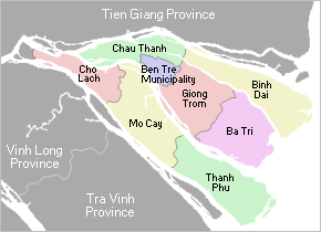
Châu Thành is a rural district of Bến Tre province in the Mekong Delta of Vietnam. As of 2019 the district had a population of 175,893. The district covers an area of 229 km². The district capital lies at Châu Thành.

Guyana, officially the Co-operative Republic of Guyana, is a country on the northern coast of South America, part of the historic mainland British West Indies. Guyana is an indigenous word which means "Land of Many Waters". Georgetown is the capital of Guyana with the largest population. Guyana is bordered by the Atlantic Ocean to the north, Brazil to the south and southwest, Venezuela to the west, and Suriname to the east. With a land area of 214,969 km2 (83,000 sq mi), Guyana is the third-smallest sovereign state by area in mainland South America after Uruguay and Suriname, and is the second-least populous sovereign state in South America after Suriname; it is also one of the least densely populated countries on Earth. It has a wide variety of natural habitats and very high biodiversity. The country also hosts one part of the Amazon rainforest, the largest tropical rainforest in the world.
This is a list of the extreme points and extreme elevations in Wales.
The Kurupung River is a tributary of the middle Mazaruni River in Guyana.
The Eping River is a tributary of the Kamarang River in Region 8 of Guyana.

The borders of the oceans are the limits of Earth's oceanic waters. The definition and number of oceans can vary depending on the adopted criteria. The principal divisions of the five oceans are the Pacific Ocean, Atlantic Ocean, Indian Ocean, Southern (Antarctic) Ocean, and Arctic Ocean. Smaller regions of the oceans are called seas, gulfs, bays, straits, and other terms. Geologically, an ocean is an area of oceanic crust covered by water.

The borders of Suriname consist of land borders with three countries: Guyana, Brazil, and France. The borders with Guyana and France are in dispute, but the border with Brazil has been uncontroversial since 1906.

The Tigri Area is a wooded area that has been disputed by Guyana and Suriname since around 1840. It involves the area between the Upper Corentyne River, the Coeroeni River, and the Kutari River. This triangular area is known as the New River Triangle in Guyana. In 1969 the conflict ran high on, and since then it has been controlled by Guyana and claimed by Suriname. In 1971, both governments agreed that they would continue talks over the border issue and withdraw their military forces from the disputed triangle. Guyana has never held upon this agreement.
Corozal Bay is an inlet of Chetumal Bay, indenting northern Belize. Several resort areas are located on the coast of the bay, most notably Corozal Town. The New River (Belize) flows north into the bay. The town of Consejo is located north-northeast of the bay, on the much larger Chetumal Bay. The Mayan ruins of Cerros are located on the bay.
References
- Rand McNally, The New International Atlas, 1993.
6°21′N60°22′W / 6.350°N 60.367°W