
Barima-Waini is a region of Guyana and is located in the northwest of the country. Barima-Waini has three sub-regions: Mabaruma, Matakai, and Moruca.
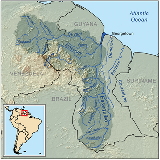
The Cuyuni River is a South American river and a tributary of the Essequibo River. It rises in the Guiana Highlands of Venezuela, where it descends northward to El Dorado, and turns eastward to meander through the tropical rain forests of the Cuyuni-Mazaruni Region of Guyana. It finally turns southeastward, flowing to its confluence with the Mazaruni River.

The Mazaruni River is a tributary of the Essequibo River in northern Guyana. Its source is in the remote western forests of the Pakaraima Mountains and its confluence with the Cuyuni River is near Bartica. As it descends from the Guiana Highlands the river runs south-east, past Issano, then northward to Bartica. The river is a source of alluvial gold.
Kartabo is a village in the Cuyuni-Mazaruni Region of Guyana.
Imbaimadai is a community in the Cuyuni-Mazaruni Region of Guyana.

Kamarang is an Amerindian village, standing at the confluence of the Kamarang River and Mazaruni River, in the Cuyuni-Mazaruni Region of Guyana.
The Siparuni River is a river in the Potaro-Siparuni Region of Guyana. It is a tributary of the Essequibo River. Tributaries of the Siparuni River include the Takutu River, Burro-Burro River, Tipuru River and Levai Creek.
Kabakaburi is an Amerindian village in the Pomeroon-Supenaam Region of Guyana on the Pomeroon River, 56 km (35 mi) from its mouth. The village was founded in 1845 by William Henry Brett on the location where Fort Durban used to be.
Kurupung is a mining community in the Cuyuni-Mazaruni Region of Guyana, near the Pakaraima Mountains.

The Akawaio are an indigenous people who live in Roraima (Brazil), Guyana, and Venezuela. They are one of several closely related peoples called Ingarikó and Kapon. The Akawaio language is used by 5,000 to 6,000 speakers.
The Puruni River is a river of Guyana in the Cuyuni-Mazaruni region.
The Ekareku River is a river of Guyana, a tributary of the Wenamu River.
The Oko River is a river of Guyana, a tributary of the Wenamu River and a part of the middle-Mazaruni.
The Toroparu mine is estimated to be one of the largest gold mining projects in Guyana. The mine is located in the north-west of the country in Cuyuni-Mazaruni. The mine has estimated reserves of 6 million oz of gold.

Indigenous peoples in Guyana, Native Guyanese or Amerindian Guyanese are Guyanese people who are of indigenous ancestry. They comprise approximately 9.16% of Guyana's population. Amerindians are credited with the invention of the canoe, as well as Cassava-based dishes and Guyanese pepperpot, the national dish of Guyana. Amerindian languages have also been incorporated in the lexicon of Guyanese Creole.
Issano is a village of Cuyuni-Mazaruni, Guyana. It's located along the Mazaruni River, and is a hub for mining.
Isseneru is an Amerindian settlement in the Cuyuni-Mazaruni region of Guyana, approximately 15–20 miles west of Kurupung.
Paruima is an indigenous village of Pemon Amerindians in the Cuyuni-Mazaruni Region of Guyana. The village was founded as a mission of the Seventh-day Adventist Church. It is the only Pemon speaking community in Guyana.
Alleluia is a syncretic religion combining Christianity and traditions practiced by Carib-speaking Indigenous peoples in Guyana.

Dawn Hastings-Williams is a Guyanese politician. She has been a member of the National Assembly since 2011. She has previously served as Minister within the Ministry of Communities (2015-2017), Minister of Public Affairs (2017–2019), and Minister of State (2019–2020).
