Delta Amacuro State is one of the 23 states of Venezuela, and is the location of the Orinoco Delta. The Paria Gulf and the Atlantic Ocean are found to the north, Bolívar State is found to the south, the Atlantic Ocean and Guyana are found to the east, and Monagas State is found to the west. The state capital city is Tucupita.

Barima-Waini is a region of Guyana and is located in the northwest of the country. Barima-Waini has three sub-regions: Mabaruma, Matakai, and Moruca.

Port Kaituma is a small village within the Barima-Waini administrative region of Guyana. It became known internationally as a gateway village to the Peoples Temple settlement in nearby Jonestown. It has long been a hub for mining in the area.

Mabaruma is the administrative centre and regional capital for Region One (Barima-Waini) of Guyana. It is located close to the Aruka River on a narrow plateau above the surrounding rainforest at an elevation of 13 metres.
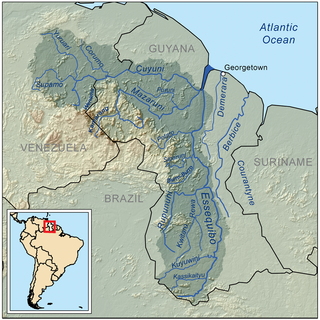
The Cuyuni River is a South American river and a tributary of the Essequibo River. It rises in the Guiana Highlands of Venezuela, where it descends northward to El Dorado, and turns eastward to meander through the tropical rain forests of the Cuyuni-Mazaruni Region of Guyana. It finally turns southeastward, flowing to its confluence with the Mazaruni River.

The Bolivarian Republic of Venezuela is a federation made up of twenty-three states, a Capital District and the Federal Dependencies, which consist of many islands and islets in the Caribbean Sea. Venezuela claims the disputed Essequibo territory as one of its states, which it calls Guayana Esequiba, but the territory is controlled by Guyana as part of six of its regions.

Charity is a small township in Guyana, located in the Pomeroon-Supenaam Region No.2, which is part of the Essequibo County.

The Warao are an Indigenous Amerindian people inhabiting northeastern Venezuela, Trinidad and Tobago, Guyana, and Suriname. Alternate common spellings of Warao are Waroa, Guarauno, Guarao, and Warrau. The term Warao translates as "the boat people", after the Warao's lifelong and intimate connection to the water. Most Warao inhabit Venezuela's Orinoco Delta region, with smaller numbers in neighbouring Guyana, Trinidad and Tobago, and Suriname. With a population of 49,271 people in Venezuela during the 2011 census, they were the second largest indigenous group after the Wayuu people. They speak an agglutinative language, Warao.

The Takutu River is a river in the Upper Takutu-Upper Essequibo Region of Guyana and Roraima in Brazil. It forms part of the boundary between the two countries. The confluence of the Takutu and Uraricoera Rivers forms the Branco River. The Takutu River's sources almost link with those of the Essequibo River; in the rainy season, flooding links the Takutu to the Rupununi River, a tributary of the Essequibo.

The Guyana–Venezuela territorial dispute is an ongoing territorial dispute between Guyana and Venezuela over the Essequibo region, also known as Esequibo or Guayana Esequiba in Spanish, a 159,500 km2 (61,600 sq mi) area west of the Essequibo River. The territory, excluding the Venezuelan-controlled Ankoko Island, is controlled by Guyana as part of six of its regions, based on the 1899 Paris Arbitral Award. It is also claimed by Venezuela as the Guayana Esequiba State. The boundary dispute was inherited from the colonial powers and has persisted following the independence of Venezuela and Guyana.
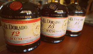
Demerara Distillers Ltd. is a Guyanese distillery known for the El Dorado Rum brand. It was at one time the world's second largest producer of rum.

Guyana, officially the Co-operative Republic of Guyana, is a country on the northern coast of South America, part of the historic mainland British West Indies. Guyana is an indigenous word which means "Land of Many Waters". Georgetown is the capital of Guyana and is also the country's largest city. Guyana is bordered by the Atlantic Ocean to the north, Brazil to the south and southwest, Venezuela to the west, and Suriname to the east. With a land area of 214,969 km2 (83,000 sq mi), Guyana is the third-smallest sovereign state by area in mainland South America after Uruguay and Suriname, and is the second-least populous sovereign state in South America after Suriname; it is also one of the least densely populated countries on Earth. It has a wide variety of natural habitats and very high biodiversity. The country also hosts a part of the Amazon rainforest, the largest tropical rainforest in the world.
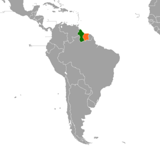
Guyana–Venezuela relations include diplomatic, economic and other interactions between the neighboring countries of the Co-operative Republic of Guyana and the Bolivarian Republic of Venezuela.
Wenamu River is a river in South America. It forms a portion of the international boundary between Venezuela and Guyana. It is part of the Essequibo River basin.
Guyana – Suriname relations are the bilateral relations between Guyana and Suriname. Suriname has an embassy in Georgetown. Guyana has an embassy in Paramaribo. The Courentyne River makes up most of the border between the two countries.

Mohamed Irfaan Ali is a Guyanese politician serving as the tenth and current president of Guyana since 2020. A member of the People's Progressive Party/Civic (PPP/C), he previously served as the minister of Housing and Water from 2009 to 2015. He is the first Muslim to hold office, and is the third Muslim head of state in the Americas after Noor Hassanali of Trinidad and Tobago and Carlos Saul Menem of Argentina.
The COVID-19 pandemic in Guyana was a part of the worldwide pandemic of coronavirus disease 2019 caused by severe acute respiratory syndrome coronavirus 2. The virus was confirmed to have reached Guyana on 11 March 2020. The first case was a woman who travelled from New York, a 52-year-old woman with underlying health conditions, including diabetes and hypertension. The woman died at the Georgetown Public Hospital.
Rewa is an Amerindian village in the Upper Takutu-Upper Essequibo region of Guyana.
Isseneru is an Amerindian settlement in the Cuyuni-Mazaruni region of Guyana, approximately 15–20 miles west of Kurupung.
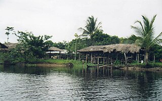
Whitewater is a village in the Barima-Waini Region of Guyana. Whitewater is located close to the border with Venezuela and is inhabited by Warao Amerindians.
